![](/images/other/stat-length.png)
![Trail On foot Unknown - National park Paklenica - Photo](https://media.geolcdn.com/t/1900/400/afedae5b-4209-4d66-bdba-6cfba3f997ff.jpeg&format=pjpeg&maxdim=2)
National park Paklenica
SityTrail - itinéraires balisés pédestres
Tous les sentiers balisés d’Europe GUIDE+
![Length](/images/other/stat-length.png)
![Max alt](https://static1.geolcdn.com/siteimages/upload/files/1508320355ic_sort_altitude_max_24dp.png)
![Uphill gradient](https://static1.geolcdn.com/siteimages/upload/files/1508320355ic_sort_den_pos_24dp.png)
![Km-Effort](/images/other/stat-length.png)
![Min alt](https://static1.geolcdn.com/siteimages/upload/files/1508320355ic_sort_altitude_min_24dp.png)
![Downhill gradient](https://static1.geolcdn.com/siteimages/upload/files/1508320355ic_sort_den_neg_24dp.png)
![Boucle](https://static1.geolcdn.com/siteimages/upload/files/16400158638029165_repeat_loop_refresh_sync_direction_icon.png)
![On foot](https://static1.geolcdn.com/sitytour/trail-icons/100.png)
4h46
Difficulty : Medium
![Scan this QR Code to open this trail in the SityTrail application](https://capi.geolives.com/qq0zvz2zws4bq2lad0pu/sitytour/trails/4346147/qr.png?size=200)
FREE GPS app for hiking
About
Trail On foot of 11.7 km to be discovered at Unknown, Lika-Senj County. This trail is proposed by SityTrail - itinéraires balisés pédestres.
Description
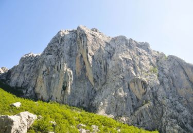
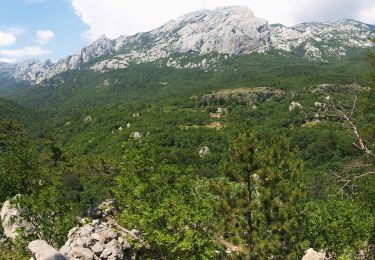
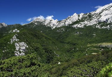
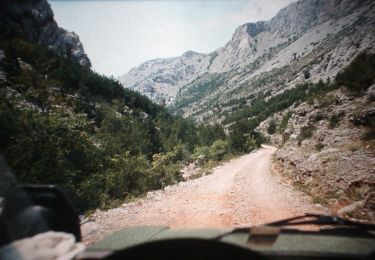
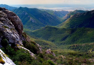
The area of Paklenica is one of the most interesting karst areas of Velebit and Croatia. At the base of the series of the highest peaks of Velebit, torrents have created two deep canyons representing a combination of longitudinal and deeply cut valleys in geomorphological terms. The most ...
Website: https://trail.viadinarica.com/tour/hiking/15966852/
Positioning
Comments
Trails nearby
![Trail On foot - Bukova staza - Photo](https://media.geolcdn.com/t/375/260/0293162d-3a5f-4b15-b737-440dbc2c1183.jpeg&format=jpg&maxdim=2)
![On foot On foot](https://static1.geolcdn.com/sitytour/trail-icons/100.png)
![Trail On foot - Dom u Velikoj Paklenici - Krajni brig - Photo](https://media.geolcdn.com/t/375/260/9b12ad8e-78b9-402d-9026-622d8b2790f2.jpeg&format=jpg&maxdim=2)
![On foot On foot](https://static1.geolcdn.com/sitytour/trail-icons/100.png)
On foot
![](/images/other/stat-length.png)
![](https://static1.geolcdn.com/siteimages/upload/files/16400158638029165_repeat_loop_refresh_sync_direction_icon.png)
![Trail On foot - Golić - Stražbenica - Photo](https://media.geolcdn.com/t/375/260/1fb005e9-31bf-41ad-b0c1-91bb8d8fb8c4.jpeg&format=jpg&maxdim=2)
![On foot On foot](https://static1.geolcdn.com/sitytour/trail-icons/100.png)
![Trail On foot - Dom u Velikoj Paklenici - Stražbenica - Photo](https://media.geolcdn.com/t/375/260/74943b82-bfa9-49f1-8ba4-6b0b9dfe9937.jpeg&format=jpg&maxdim=2)
![On foot On foot](https://static1.geolcdn.com/sitytour/trail-icons/100.png)
On foot
![](/images/other/stat-length.png)
![](https://static1.geolcdn.com/siteimages/upload/files/16400158638029165_repeat_loop_refresh_sync_direction_icon.png)
![Trail On foot - Lipa staza - Photo](https://media.geolcdn.com/t/375/260/cd3917a8-4228-43c8-9d12-c2fc6fd497bd.jpeg&format=jpg&maxdim=2)
![On foot On foot](https://static1.geolcdn.com/sitytour/trail-icons/100.png)
![Trail On foot - Struge - Vaganski vrh - Photo](https://media.geolcdn.com/t/375/260/3896feef-29ff-4652-b14a-a616281106d1.jpeg&format=jpg&maxdim=2)
![On foot On foot](https://static1.geolcdn.com/sitytour/trail-icons/100.png)
On foot
![](/images/other/stat-length.png)
![](https://static1.geolcdn.com/siteimages/upload/files/16400158638029165_repeat_loop_refresh_sync_direction_icon.png)
![Trail On foot - Vaganski vrh - Sveto Brdo - Photo](https://media.geolcdn.com/t/375/260/afedae5b-4209-4d66-bdba-6cfba3f997ff.jpeg&format=jpg&maxdim=2)
![On foot On foot](https://static1.geolcdn.com/sitytour/trail-icons/100.png)
On foot
![](/images/other/stat-length.png)
![](https://static1.geolcdn.com/siteimages/upload/files/16400158638029165_repeat_loop_refresh_sync_direction_icon.png)
![Trail On foot - Dom u Velikoj Paklenici - Vlaški grad - Photo](https://media.geolcdn.com/t/375/260/afedae5b-4209-4d66-bdba-6cfba3f997ff.jpeg&format=jpg&maxdim=2)
![On foot On foot](https://static1.geolcdn.com/sitytour/trail-icons/100.png)
On foot
![](/images/other/stat-length.png)
![](https://static1.geolcdn.com/siteimages/upload/files/16400158638029165_repeat_loop_refresh_sync_direction_icon.png)
![Trail On foot - Dom Paklenica - Jurline - Photo](https://media.geolcdn.com/t/375/260/74943b82-bfa9-49f1-8ba4-6b0b9dfe9937.jpeg&format=jpg&maxdim=2)
![On foot On foot](https://static1.geolcdn.com/sitytour/trail-icons/100.png)
On foot
![](/images/other/stat-length.png)
![](https://static1.geolcdn.com/siteimages/upload/files/16400158638029165_repeat_loop_refresh_sync_direction_icon.png)