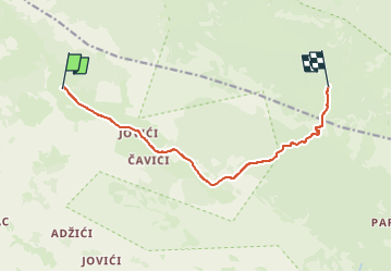
![](/images/other/stat-length.png)
![Trail On foot Unknown - Southern Velebit III – route to Struge - Photo](https://media.geolcdn.com/t/1900/400/3896feef-29ff-4652-b14a-a616281106d1.jpeg&format=pjpeg&maxdim=2)
Southern Velebit III – route to Struge
SityTrail - itinéraires balisés pédestres
Tous les sentiers balisés d’Europe GUIDE+
![Length](/images/other/stat-length.png)
![Max alt](https://static1.geolcdn.com/siteimages/upload/files/1508320355ic_sort_altitude_max_24dp.png)
![Uphill gradient](https://static1.geolcdn.com/siteimages/upload/files/1508320355ic_sort_den_pos_24dp.png)
![Km-Effort](/images/other/stat-length.png)
![Min alt](https://static1.geolcdn.com/siteimages/upload/files/1508320355ic_sort_altitude_min_24dp.png)
![Downhill gradient](https://static1.geolcdn.com/siteimages/upload/files/1508320355ic_sort_den_neg_24dp.png)
![Boucle](https://static1.geolcdn.com/siteimages/upload/files/16400158638029165_repeat_loop_refresh_sync_direction_icon.png)
![On foot](https://static1.geolcdn.com/sitytour/trail-icons/100.png)
3h52
Difficulty : Easy
![Scan this QR Code to open this trail in the SityTrail application](https://capi.geolives.com/qq0zvz2zws4bq2lad0pu/sitytour/trails/4346144/qr.png?size=200)
FREE GPS app for hiking
About
Trail On foot of 9.7 km to be discovered at Unknown, Zadar County. This trail is proposed by SityTrail - itinéraires balisés pédestres.
Description
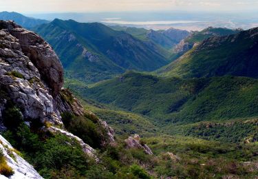
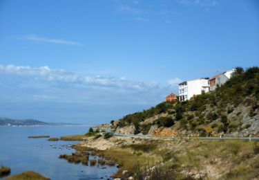
The area between Visočica and the peaks above Paklenica is not characterized by high peaks, and the key hiking destinations are oriented to the coastal side of the mountain. This is karst terrain, with an interesting series of several spacious karst valleys with virgin forests and large fields ...
Website: https://trail.viadinarica.com/tour/hiking/15966765/
Positioning
Comments
Trails nearby
![Trail On foot - Čavići - Veliko Rujno - Photo](https://media.geolcdn.com/t/375/260/1bf39b20-6ae1-48c2-8fe8-1805a11a901c.jpeg&format=jpg&maxdim=2)
![On foot On foot](https://static1.geolcdn.com/sitytour/trail-icons/100.png)
On foot
![](/images/other/stat-length.png)
![](https://static1.geolcdn.com/siteimages/upload/files/16400158638029165_repeat_loop_refresh_sync_direction_icon.png)
![Trail On foot - Oglavinovac - Struge - Photo](https://media.geolcdn.com/t/375/260/3896feef-29ff-4652-b14a-a616281106d1.jpeg&format=jpg&maxdim=2)
![On foot On foot](https://static1.geolcdn.com/sitytour/trail-icons/100.png)
On foot
![](/images/other/stat-length.png)
![](https://static1.geolcdn.com/siteimages/upload/files/16400158638029165_repeat_loop_refresh_sync_direction_icon.png)
![Trail On foot - Šibuljina - Malo Rujno - Photo](https://media.geolcdn.com/t/375/260/a5cd334b-5280-4c3f-967d-0b550833f2c6.jpeg&format=jpg&maxdim=2)
![On foot On foot](https://static1.geolcdn.com/sitytour/trail-icons/100.png)
On foot
![](/images/other/stat-length.png)
![](https://static1.geolcdn.com/siteimages/upload/files/16400158638029165_repeat_loop_refresh_sync_direction_icon.png)
![Trail On foot - Rujno - Oglavinovac - Photo](https://media.geolcdn.com/t/375/260/ext.jpg?maxdim=2&url=https%3A%2F%2Fstatic1.geolcdn.com%2Fsiteimages%2Fupload%2Ffiles%2F1545311037marcheuse_200dpi.jpg)
![On foot On foot](https://static1.geolcdn.com/sitytour/trail-icons/100.png)
On foot
![](/images/other/stat-length.png)
![](https://static1.geolcdn.com/siteimages/upload/files/16400158638029165_repeat_loop_refresh_sync_direction_icon.png)
![Trail On foot - Vaganac - Bojinac - Photo](https://media.geolcdn.com/t/375/260/ext.jpg?maxdim=2&url=https%3A%2F%2Fstatic1.geolcdn.com%2Fsiteimages%2Fupload%2Ffiles%2F1545311037marcheuse_200dpi.jpg)
![On foot On foot](https://static1.geolcdn.com/sitytour/trail-icons/100.png)