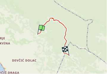
![](/images/other/stat-length.png)
![Trail On foot Unknown - Southern Velebit II – route to Stap - Photo](https://media.geolcdn.com/t/1900/400/dec1b585-9c95-440b-9afc-bdefe2605220.jpeg&format=pjpeg&maxdim=2)
Southern Velebit II – route to Stap
SityTrail - itinéraires balisés pédestres
Tous les sentiers balisés d’Europe GUIDE+
![Length](/images/other/stat-length.png)
![Max alt](https://static1.geolcdn.com/siteimages/upload/files/1508320355ic_sort_altitude_max_24dp.png)
![Uphill gradient](https://static1.geolcdn.com/siteimages/upload/files/1508320355ic_sort_den_pos_24dp.png)
![Km-Effort](/images/other/stat-length.png)
![Min alt](https://static1.geolcdn.com/siteimages/upload/files/1508320355ic_sort_altitude_min_24dp.png)
![Downhill gradient](https://static1.geolcdn.com/siteimages/upload/files/1508320355ic_sort_den_neg_24dp.png)
![Boucle](https://static1.geolcdn.com/siteimages/upload/files/16400158638029165_repeat_loop_refresh_sync_direction_icon.png)
![On foot](https://static1.geolcdn.com/sitytour/trail-icons/100.png)
2h46
Difficulty : Easy
![Scan this QR Code to open this trail in the SityTrail application](https://capi.geolives.com/qq0zvz2zws4bq2lad0pu/sitytour/trails/4346143/qr.png?size=200)
FREE GPS app for hiking
About
Trail On foot of 8.2 km to be discovered at Unknown, Lika-Senj County. This trail is proposed by SityTrail - itinéraires balisés pédestres.
Description
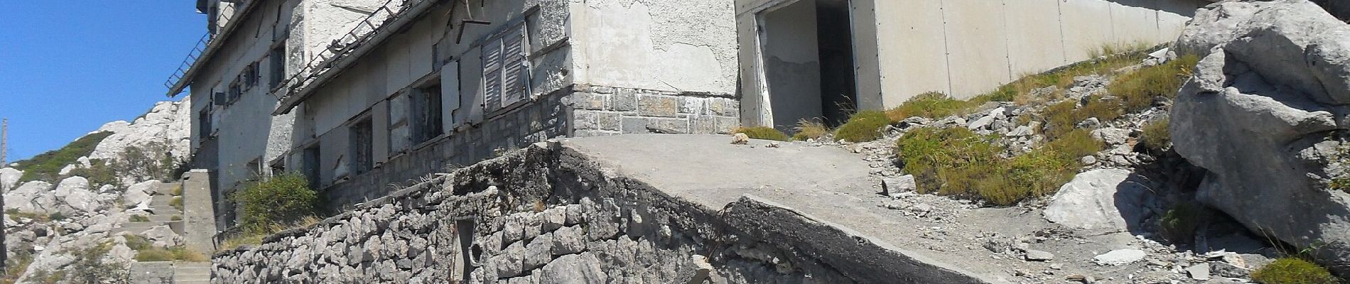
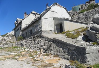
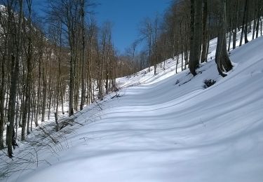
The section from Šugarska duliba to Stap offers genuine wilderness, with forest calm and tranquility dominating this wide area. The only longitudinal trail in this area is the Velebit Hiking Trail. This section requires 5 hours of hiking.
Website: https://trail.viadinarica.com/tour/hiking/15966597/
Positioning
Comments
Trails nearby
![Trail On foot - Stap - Jelova Ruja - Photo](https://media.geolcdn.com/t/375/260/dec1b585-9c95-440b-9afc-bdefe2605220.jpeg&format=jpg&maxdim=2)
![On foot On foot](https://static1.geolcdn.com/sitytour/trail-icons/100.png)
![Trail On foot - Jelova Ruja - Jandrina poljana - Photo](https://media.geolcdn.com/t/375/260/fae9f49c-d8f4-4ef3-adb5-5b866626d596.jpeg&format=jpg&maxdim=2)
![On foot On foot](https://static1.geolcdn.com/sitytour/trail-icons/100.png)
On foot
![](/images/other/stat-length.png)
![](https://static1.geolcdn.com/siteimages/upload/files/16400158638029165_repeat_loop_refresh_sync_direction_icon.png)
![Trail On foot - Šugarska staza - Photo](https://media.geolcdn.com/t/375/260/0db3540d-6872-477d-a1e1-486c1b1204db.jpeg&format=jpg&maxdim=2)
![On foot On foot](https://static1.geolcdn.com/sitytour/trail-icons/100.png)
![Trail On foot - Križac - Šugarska duliba - Photo](https://media.geolcdn.com/t/375/260/c7961c24-4930-4b23-8309-b52999876b7a.jpeg&format=jpg&maxdim=2)
![On foot On foot](https://static1.geolcdn.com/sitytour/trail-icons/100.png)
On foot
![](/images/other/stat-length.png)
![](https://static1.geolcdn.com/siteimages/upload/files/16400158638029165_repeat_loop_refresh_sync_direction_icon.png)
![Trail On foot - Kruščica - Stap - Photo](https://media.geolcdn.com/t/375/260/cfffeff4-44e6-4508-a23e-83578ab1cdc9.jpeg&format=jpg&maxdim=2)
![On foot On foot](https://static1.geolcdn.com/sitytour/trail-icons/100.png)
![Trail On foot - Brušane - Ripište - Photo](https://media.geolcdn.com/t/375/260/b12f2aaa-8345-4da9-96d6-84b618709aa1.jpeg&format=jpg&maxdim=2)
![On foot On foot](https://static1.geolcdn.com/sitytour/trail-icons/100.png)
On foot
![](/images/other/stat-length.png)
![](https://static1.geolcdn.com/siteimages/upload/files/16400158638029165_repeat_loop_refresh_sync_direction_icon.png)
![Trail On foot - Stap - odvojak za Panos - Photo](https://media.geolcdn.com/t/375/260/ext.jpg?maxdim=2&url=https%3A%2F%2Fstatic1.geolcdn.com%2Fsiteimages%2Fupload%2Ffiles%2F1545311037marcheuse_200dpi.jpg)
![On foot On foot](https://static1.geolcdn.com/sitytour/trail-icons/100.png)
On foot
![](/images/other/stat-length.png)
![](https://static1.geolcdn.com/siteimages/upload/files/16400158638029165_repeat_loop_refresh_sync_direction_icon.png)
![Trail On foot - Stap - Veliko Rujno - Photo](https://media.geolcdn.com/t/375/260/ext.jpg?maxdim=2&url=https%3A%2F%2Fstatic1.geolcdn.com%2Fsiteimages%2Fupload%2Ffiles%2F1545311037marcheuse_200dpi.jpg)
![On foot On foot](https://static1.geolcdn.com/sitytour/trail-icons/100.png)
On foot
![](/images/other/stat-length.png)
![](https://static1.geolcdn.com/siteimages/upload/files/16400158638029165_repeat_loop_refresh_sync_direction_icon.png)