![](/images/other/stat-length.png)
![Trail On foot Unknown - Dabri and Dabarski kukovi - Photo](https://media.geolcdn.com/t/1900/400/a3fc5cbc-c56a-4353-8e9f-847f775b7f23.jpeg&format=pjpeg&maxdim=2)
Dabri and Dabarski kukovi
SityTrail - itinéraires balisés pédestres
Tous les sentiers balisés d’Europe GUIDE+
![Length](/images/other/stat-length.png)
![Max alt](https://static1.geolcdn.com/siteimages/upload/files/1508320355ic_sort_altitude_max_24dp.png)
![Uphill gradient](https://static1.geolcdn.com/siteimages/upload/files/1508320355ic_sort_den_pos_24dp.png)
![Km-Effort](/images/other/stat-length.png)
![Min alt](https://static1.geolcdn.com/siteimages/upload/files/1508320355ic_sort_altitude_min_24dp.png)
![Downhill gradient](https://static1.geolcdn.com/siteimages/upload/files/1508320355ic_sort_den_neg_24dp.png)
![Boucle](https://static1.geolcdn.com/siteimages/upload/files/16400158638029165_repeat_loop_refresh_sync_direction_icon.png)
![On foot](https://static1.geolcdn.com/sitytour/trail-icons/100.png)
3h58
Difficulty : Easy
![Scan this QR Code to open this trail in the SityTrail application](https://capi.geolives.com/qq0zvz2zws4bq2lad0pu/sitytour/trails/4346138/qr.png?size=200)
FREE GPS app for hiking
About
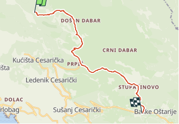
Trail On foot of 11.8 km to be discovered at Unknown, Lika-Senj County. This trail is proposed by SityTrail - itinéraires balisés pédestres.
Description
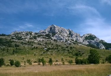
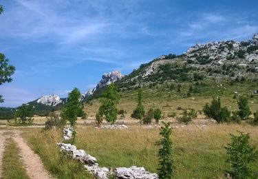
Unlike the section of central Velebit to the north, which is higher, but also characterized by grassland peaks with gentle terrain, the continuation of this ridge from Bačić kuk to Ljubičko brdo above Oštarije is completely different. Here, as in no other place in the area, we come across an ...
Website: https://trail.viadinarica.com/tour/hiking/15957781/
Positioning
Comments
Trails nearby
![Trail On foot - Bačić kuk iz Ravnog Dabra preko Bačić dulibe i Ripinovca - Photo](https://media.geolcdn.com/t/375/260/d8704096-4b2c-408f-a8a9-50355c2bdd68.jpeg&format=jpg&maxdim=2)
![On foot On foot](https://static1.geolcdn.com/sitytour/trail-icons/100.png)
On foot
![](/images/other/stat-length.png)
![](https://static1.geolcdn.com/siteimages/upload/files/16400158638029165_repeat_loop_refresh_sync_direction_icon.png)
![Trail On foot - Dabarska Kosa - Photo](https://media.geolcdn.com/t/375/260/935528d5-1608-4982-8fa2-359bf773c124.jpeg&format=jpg&maxdim=2)
![On foot On foot](https://static1.geolcdn.com/sitytour/trail-icons/100.png)
![Trail On foot - Ravni dabar do Alaginca preko Crnog dabra - Photo](https://media.geolcdn.com/t/375/260/44308a08-29b0-4c7d-91b3-8b16213eb85c.jpeg&format=jpg&maxdim=2)
![On foot On foot](https://static1.geolcdn.com/sitytour/trail-icons/100.png)
On foot
![](/images/other/stat-length.png)
![](https://static1.geolcdn.com/siteimages/upload/files/16400158638029165_repeat_loop_refresh_sync_direction_icon.png)
![Trail On foot - Grebenski put kroz Dabarske kukove - Photo](https://media.geolcdn.com/t/375/260/6078a130-33f5-43a0-ba0a-a1b94e9a4dfb.jpeg&format=jpg&maxdim=2)
![On foot On foot](https://static1.geolcdn.com/sitytour/trail-icons/100.png)
On foot
![](/images/other/stat-length.png)
![](https://static1.geolcdn.com/siteimages/upload/files/16400158638029165_repeat_loop_refresh_sync_direction_icon.png)
![Trail On foot - Od magistrale do Premužićeve staze (Splovine) preko Radlovca - Photo](https://media.geolcdn.com/t/375/260/9a432c00-eef7-49e7-9fb3-0eb8fe4d1213.jpeg&format=jpg&maxdim=2)
![On foot On foot](https://static1.geolcdn.com/sitytour/trail-icons/100.png)
On foot
![](/images/other/stat-length.png)
![](https://static1.geolcdn.com/siteimages/upload/files/16400158638029165_repeat_loop_refresh_sync_direction_icon.png)
![Trail On foot - Kugina kuća od Premužićeve staze kod Skorpovca - Photo](https://media.geolcdn.com/t/375/260/b0f78ffd-a4f9-4305-8a45-70144e484edb.jpeg&format=jpg&maxdim=2)
![On foot On foot](https://static1.geolcdn.com/sitytour/trail-icons/100.png)
On foot
![](/images/other/stat-length.png)
![](https://static1.geolcdn.com/siteimages/upload/files/16400158638029165_repeat_loop_refresh_sync_direction_icon.png)