Trail On foot Unknown - Tršće - Sveta gora - Source of Kupa - Crni Lug - Photo

Tršće - Sveta gora - Source of Kupa - Crni Lug

Tous les sentiers balisés d’Europe GUIDE+

© OpenStreetMap contributors
Length
Length
15.3 km
Max alt
Max alt
948 m
Uphill gradient
Uphill gradient
525 m
Km-Effort
Km-Effort  
24 km
Min alt
Min alt
311 m
Downhill gradient
Downhill gradient
1012 m
Boucle
Boucle
No
Signpost
Signpost
Creation date :
2025-02-07 16:02:45.125
Updated on :
2025-02-07 16:02:45.125

(0 Reviews)

On foot
On foot
5h25
Difficulty : Medium

Scan this QR Code to open this trail in the SityTrail application

FREE GPS app for hiking

Logo SityTrail SityTrail

IGN / Geographical institutes

Download SityTrail from the App Store Download SityTrail from Google Play

Logo SityTrail SityTrail World

The world is yours!

Download SityTrail from the App Store Download SityTrail from Google Play Download SityTrail on Huawei AppGallery

About

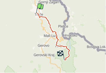
Trail On foot of 15.3 km to be discovered at Unknown, Primorje-Gorski Kotar County. This trail is proposed by SityTrail - itinéraires balisés pédestres.

Description

In the area from Tršće to Risnjak National Park, Via Dinarica follows the route of Gorski Kotar Hiking Trail. The trail is well kept and maintained. From Tršće, we first need to climb to the village of Kraljev Vrh by road. From there, we then continue by following the hiking trail markings ...

Website: https://trail.viadinarica.com/tour/hiking/15948208/

Elevation profile

Photos

Positioning

Country:
Croatia
Region :
Unknown
Department/Province :
Primorje-Gorski Kotar County
Municipality :
Unknown
Location:
Unknown
Start:(UTM)
470662 ; 5046214 (33T) N.

Trails nearby

Trail On foot  - Prezid - Čabar - Tršće - Photo
On foot
GUIDE+

On foot

Easy
, Unknown, Primorje-Gorski Kotar County, Croatia
4.9 km | 7.1 km-effort
1h 36min
No


Close
My subscriptions