![](/images/other/stat-length.png)
![Trail On foot Hradištko - NS na Medníku - Photo](https://media.geolcdn.com/t/1900/400/85cf8519-a29b-45d1-b6db-87852bdd196a.jpeg&format=pjpeg&maxdim=2)
NS na Medníku
SityTrail - itinéraires balisés pédestres
Tous les sentiers balisés d’Europe GUIDE+
![Length](/images/other/stat-length.png)
Length
6 km
![Max alt](https://static1.geolcdn.com/siteimages/upload/files/1508320355ic_sort_altitude_max_24dp.png)
Max alt
384 m
![Uphill gradient](https://static1.geolcdn.com/siteimages/upload/files/1508320355ic_sort_den_pos_24dp.png)
Uphill gradient
200 m
![Km-Effort](/images/other/stat-length.png)
Km-Effort
8.7 km
![Min alt](https://static1.geolcdn.com/siteimages/upload/files/1508320355ic_sort_altitude_min_24dp.png)
Min alt
201 m
![Downhill gradient](https://static1.geolcdn.com/siteimages/upload/files/1508320355ic_sort_den_neg_24dp.png)
Downhill gradient
212 m
![Boucle](https://static1.geolcdn.com/siteimages/upload/files/16400158638029165_repeat_loop_refresh_sync_direction_icon.png)
Boucle
No
Signpost
Creation date :
2025-02-07 15:03:41.025
Updated on :
2025-02-07 15:03:41.025
![On foot](https://static1.geolcdn.com/sitytour/trail-icons/100.png)
1h58
Difficulty : Easy
![Scan this QR Code to open this trail in the SityTrail application](https://capi.geolives.com/qq0zvz2zws4bq2lad0pu/sitytour/trails/4345958/qr.png?size=200)
FREE GPS app for hiking
About
Trail On foot of 6 km to be discovered at Central Bohemia, Unknown, Hradištko. This trail is proposed by SityTrail - itinéraires balisés pédestres.
Description
Trail created by ČSOP, Středočeský kraj.
Positioning
Country:
Czech Republic
Region :
Central Bohemia
Department/Province :
Unknown
Municipality :
Hradištko
Location:
Unknown
Start:(Dec)
Start:(UTM)
459703 ; 5525006 (33U) N.
Comments
Trails nearby
![Trail On foot Hradištko - [Ž] NS vystěhované Hradišťko - Photo](https://media.geolcdn.com/t/375/260/b64e2764-8001-4a66-a61a-edb642656664.jpeg&format=jpg&maxdim=2)
![On foot On foot](https://static1.geolcdn.com/sitytour/trail-icons/100.png)
[Ž] NS vystěhované Hradišťko
On foot
Easy
Hradištko,
Central Bohemia,
Unknown,
Czech Republic
![](/images/other/stat-length.png)
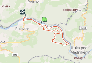
8.6 km | 11.4 km-effort
2h 35min
![](https://static1.geolcdn.com/siteimages/upload/files/16400158638029165_repeat_loop_refresh_sync_direction_icon.png)
No
![Trail On foot Bojanovice - [Z] Štěchovice - Nový Knín - Photo](https://media.geolcdn.com/t/375/260/3abfdc1c-a054-4737-a058-bae860c04258.jpeg&format=jpg&maxdim=2)
![On foot On foot](https://static1.geolcdn.com/sitytour/trail-icons/100.png)
[Z] Štěchovice - Nový Knín
On foot
Easy
Bojanovice,
Central Bohemia,
Unknown,
Czech Republic
![](/images/other/stat-length.png)
11.1 km | 13 km-effort
2h 57min
![](https://static1.geolcdn.com/siteimages/upload/files/16400158638029165_repeat_loop_refresh_sync_direction_icon.png)
No
![Trail On foot Měchenice - [M] Měchenice - Všenory - Photo](https://media.geolcdn.com/t/375/260/06630537-e029-451b-a301-b274a78a918c.jpeg&format=jpg&maxdim=2)
![On foot On foot](https://static1.geolcdn.com/sitytour/trail-icons/100.png)
[M] Měchenice - Všenory
On foot
Easy
Měchenice,
Central Bohemia,
Unknown,
Czech Republic
![](/images/other/stat-length.png)
8.2 km | 11.1 km-effort
2h 31min
![](https://static1.geolcdn.com/siteimages/upload/files/16400158638029165_repeat_loop_refresh_sync_direction_icon.png)
No
![Trail On foot Petrov - [Č] Jílovské vyhlídky - okruh - Photo](https://media.geolcdn.com/t/375/260/79529de6-ead8-47c9-94dd-a6d50a4da4ed.jpeg&format=jpg&maxdim=2)
![On foot On foot](https://static1.geolcdn.com/sitytour/trail-icons/100.png)
[Č] Jílovské vyhlídky - okruh
On foot
Medium
Petrov,
Central Bohemia,
Unknown,
Czech Republic
![](/images/other/stat-length.png)
15.8 km | 21 km-effort
4h 52min
![](https://static1.geolcdn.com/siteimages/upload/files/16400158638029165_repeat_loop_refresh_sync_direction_icon.png)
Yes
![Trail On foot Krňany - [Z] Pikovice - Pod Třebsínem - Photo](https://media.geolcdn.com/t/375/260/9d973daa-efdc-425c-b30b-77795e7c71fa.jpeg&format=jpg&maxdim=2)
![On foot On foot](https://static1.geolcdn.com/sitytour/trail-icons/100.png)
[Z] Pikovice - Pod Třebsínem
On foot
Easy
Krňany,
Central Bohemia,
Unknown,
Czech Republic
![](/images/other/stat-length.png)
5.5 km | 7.8 km-effort
1h 46min
![](https://static1.geolcdn.com/siteimages/upload/files/16400158638029165_repeat_loop_refresh_sync_direction_icon.png)
No
![Trail On foot Kamenný Přívoz - [M] Štěchovice-Žampach - Photo](https://media.geolcdn.com/t/375/260/a821c811-bd4f-4f8f-981b-9700e5481d50.jpeg&format=jpg&maxdim=2)
![On foot On foot](https://static1.geolcdn.com/sitytour/trail-icons/100.png)
[M] Štěchovice-Žampach
On foot
Easy
Kamenný Přívoz,
Central Bohemia,
Unknown,
Czech Republic
![](/images/other/stat-length.png)
8.1 km | 10.9 km-effort
2h 28min
![](https://static1.geolcdn.com/siteimages/upload/files/16400158638029165_repeat_loop_refresh_sync_direction_icon.png)
No
![Trail On foot Štěchovice - [Z] Pod Homolí - Třebenice - Photo](https://media.geolcdn.com/t/375/260/f74490da-eba5-420f-ba19-f5f256693f47.jpeg&format=jpg&maxdim=2)
![On foot On foot](https://static1.geolcdn.com/sitytour/trail-icons/100.png)
[Z] Pod Homolí - Třebenice
On foot
Easy
Štěchovice,
Central Bohemia,
Unknown,
Czech Republic
![](/images/other/stat-length.png)
7 km | 9.1 km-effort
2h 4min
![](https://static1.geolcdn.com/siteimages/upload/files/16400158638029165_repeat_loop_refresh_sync_direction_icon.png)
No
![Trail On foot Kamenný Přívoz - [Ž] Jílové-Žampach - Photo](https://media.geolcdn.com/t/375/260/434c63fc-6fe3-4b0a-b856-0b7d89cd0676.jpeg&format=jpg&maxdim=2)
![On foot On foot](https://static1.geolcdn.com/sitytour/trail-icons/100.png)
[Ž] Jílové-Žampach
On foot
Easy
Kamenný Přívoz,
Central Bohemia,
Unknown,
Czech Republic
![](/images/other/stat-length.png)
3.6 km | 5.6 km-effort
1h 16min
![](https://static1.geolcdn.com/siteimages/upload/files/16400158638029165_repeat_loop_refresh_sync_direction_icon.png)
No
![Trail On foot Jílové u Prahy - [Z] Jílové - Libeř - Photo](https://media.geolcdn.com/t/375/260/03c11c27-8b15-4d10-932c-0290d35b865a.jpeg&format=jpg&maxdim=2)
![On foot On foot](https://static1.geolcdn.com/sitytour/trail-icons/100.png)
[Z] Jílové - Libeř
On foot
Easy
Jílové u Prahy,
Central Bohemia,
Unknown,
Czech Republic
![](/images/other/stat-length.png)
3.4 km | 4.6 km-effort
1h 3min
![](https://static1.geolcdn.com/siteimages/upload/files/16400158638029165_repeat_loop_refresh_sync_direction_icon.png)
No