Trail On foot Smolotely - NS Okolím Smolotel a Makové hory - Photo

NS Okolím Smolotel a Makové hory

Tous les sentiers balisés d’Europe GUIDE+

© OpenStreetMap contributors
Length
Length
6.8 km
Max alt
Max alt
545 m
Uphill gradient
Uphill gradient
178 m
Km-Effort
Km-Effort  
9.1 km
Min alt
Min alt
410 m
Downhill gradient
Downhill gradient
182 m
Boucle
Boucle
Yes
Signpost
Signpost
Creation date :
2025-02-07 14:32:05.433
Updated on :
2025-02-07 14:32:05.433

(0 Reviews)

On foot
On foot
2h04
Difficulty : Easy

Scan this QR Code to open this trail in the SityTrail application

FREE GPS app for hiking

Logo SityTrail SityTrail

IGN / Geographical institutes

Download SityTrail from the App Store Download SityTrail from Google Play

Logo SityTrail SityTrail World

The world is yours!

Download SityTrail from the App Store Download SityTrail from Google Play Download SityTrail on Huawei AppGallery

About

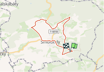
Trail On foot of 6.8 km to be discovered at Central Bohemia, Unknown, Smolotely. This trail is proposed by SityTrail - itinéraires balisés pédestres.

Elevation profile

Photos

Positioning

Country:
Czech Republic
Region :
Central Bohemia
Department/Province :
Unknown
Municipality :
Smolotely
Location:
Unknown
Start:(UTM)
438416 ; 5496349 (33U) N.

Trails nearby

Trail On foot Kozárovice - [M] Podholušice - Radětice - Photo
On foot
GUIDE+

On foot

Easy
Kozárovice, Central Bohemia, Unknown, Czech Republic
15.7 km | 19.6 km-effort
4h 27min
No


Close
My subscriptions