


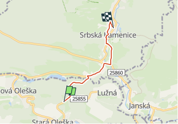

10.5 km | 14.3 km-effort
![Trail On foot Huntířov - [Z] Oleška - Srbská Kamenice - Photo](https://media.geolcdn.com/t/1900/400/b671590f-17dc-4f55-a338-c89d99bb2f15.jpeg&format=pjpeg&maxdim=2)

Tous les sentiers balisés d’Europe GUIDE+


FREE GPS app for hiking
 SityTrail
IGN / Geographical institutes
SityTrail World
The world is yours!
Trail On foot of 3.2 km to be discovered at Northwest, Ústecký kraj, Huntířov. This trail is proposed by SityTrail - itinéraires balisés pédestres.
Trail created by cz:KČT.
![Trail On foot Huntířov - [Z] Oleška - Srbská Kamenice - Photo 1](https://media.geolcdn.com/t/2048/auto/f20908d2-5523-467e-8c90-23a4122b62c1.jpeg&format=jpg&maxdim=0 "Trail On foot Huntířov - [Z] Oleška - Srbská Kamenice - Photo 1")
![Trail On foot Huntířov - [Z] Oleška - Srbská Kamenice - Photo 2](https://media.geolcdn.com/t/2048/auto/b23721a8-be35-4f37-a767-a8a1b74f01bc.jpeg&format=jpg&maxdim=0 "Trail On foot Huntířov - [Z] Oleška - Srbská Kamenice - Photo 2")
![Trail On foot Huntířov - [Z] Oleška - Srbská Kamenice - Photo 3](https://media.geolcdn.com/t/2048/auto/baf501c4-019c-4dcd-b89b-21403a319fcd.jpeg&format=jpg&maxdim=0 "Trail On foot Huntířov - [Z] Oleška - Srbská Kamenice - Photo 3")
![Trail On foot Huntířov - [Z] Oleška - Srbská Kamenice - Photo 4](https://media.geolcdn.com/t/2048/auto/b9291ea4-3eda-4ef2-ab15-50efb1c8f215.jpeg&format=jpg&maxdim=0 "Trail On foot Huntířov - [Z] Oleška - Srbská Kamenice - Photo 4")
![Trail On foot Huntířov - [Z] Oleška - Srbská Kamenice - Photo 5](https://media.geolcdn.com/t/2048/auto/99a47aa5-b9c5-4169-aefb-be140a48f396.jpeg&format=jpg&maxdim=0 "Trail On foot Huntířov - [Z] Oleška - Srbská Kamenice - Photo 5")
![Trail On foot Huntířov - [Z] Oleška - Srbská Kamenice - Photo 6](https://media.geolcdn.com/t/2048/auto/9a528611-4dc6-417b-8571-1efb7b49a386.jpeg&format=jpg&maxdim=0 "Trail On foot Huntířov - [Z] Oleška - Srbská Kamenice - Photo 6")
![Trail On foot Huntířov - [Z] Oleška - Srbská Kamenice - Photo 7](https://media.geolcdn.com/t/2048/auto/c126dd8e-b655-4828-8dba-6cba0492ad52.jpeg&format=jpg&maxdim=0 "Trail On foot Huntířov - [Z] Oleška - Srbská Kamenice - Photo 7")
![Trail On foot Huntířov - [Z] Oleška - Srbská Kamenice - Photo 8](https://media.geolcdn.com/t/2048/auto/44aa9acd-c306-4261-bff8-097ac141bb83.jpeg&format=jpg&maxdim=0 "Trail On foot Huntířov - [Z] Oleška - Srbská Kamenice - Photo 8")
![Trail On foot Huntířov - [Z] Oleška - Srbská Kamenice - Photo 9](https://media.geolcdn.com/t/2048/auto/b671590f-17dc-4f55-a338-c89d99bb2f15.jpeg&format=jpg&maxdim=0 "Trail On foot Huntířov - [Z] Oleška - Srbská Kamenice - Photo 9")
![Trail On foot Huntířov - [Z] Oleška - Srbská Kamenice - Photo 10](https://media.geolcdn.com/t/2048/auto/0d67b81b-be4f-4c74-b91d-449111f212df.jpeg&format=jpg&maxdim=0 "Trail On foot Huntířov - [Z] Oleška - Srbská Kamenice - Photo 10")
On foot
![Trail On foot Jetřichovice - [Z] Dolský mlýn - Pod Borovinou - Photo](https://media.geolcdn.com/t/375/260/cc7734bc-a1cb-44c1-a579-3999a7e367e8.jpeg&format=jpg&maxdim=2)
On foot
On foot