


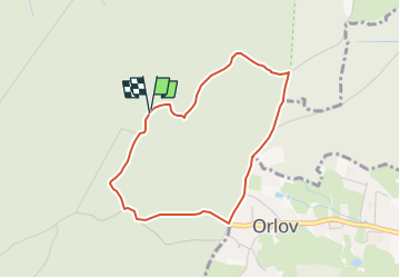

7.2 km | 9.9 km-effort
![Trail On foot Obecnice - [M] Orlov - Třemošná , místní okruh - Photo](https://media.geolcdn.com/t/1900/400/eba4fd36-4577-4ad0-82a2-9f28ca4bc9f7.jpeg&format=pjpeg&maxdim=2)

Tous les sentiers balisés d’Europe GUIDE+


FREE GPS app for hiking
 SityTrail
IGN / Geographical institutes
SityTrail World
The world is yours!
Trail On foot of 3.2 km to be discovered at Central Bohemia, Unknown, Obecnice. This trail is proposed by SityTrail - itinéraires balisés pédestres.
Trail created by cz:KČT.
![Trail On foot Obecnice - [M] Orlov - Třemošná , místní okruh - Photo 1](https://media.geolcdn.com/t/2048/auto/fa00d661-747b-4862-9de7-179b43567cd1.jpeg&format=jpg&maxdim=0 "Trail On foot Obecnice - [M] Orlov - Třemošná , místní okruh - Photo 1")
![Trail On foot Obecnice - [M] Orlov - Třemošná , místní okruh - Photo 2](https://media.geolcdn.com/t/2048/auto/e4073aea-73bd-4e8e-a916-568de9055164.jpeg&format=jpg&maxdim=0 "Trail On foot Obecnice - [M] Orlov - Třemošná , místní okruh - Photo 2")
![Trail On foot Obecnice - [M] Orlov - Třemošná , místní okruh - Photo 3](https://media.geolcdn.com/t/2048/auto/384696d8-139f-4c74-91a5-999b723e3831.jpeg&format=jpg&maxdim=0 "Trail On foot Obecnice - [M] Orlov - Třemošná , místní okruh - Photo 3")
![Trail On foot Obecnice - [M] Orlov - Třemošná , místní okruh - Photo 4](https://media.geolcdn.com/t/2048/auto/ebae6f1d-0cee-4cea-bad3-8ebd7254f4d9.jpeg&format=jpg&maxdim=0 "Trail On foot Obecnice - [M] Orlov - Třemošná , místní okruh - Photo 4")
![Trail On foot Obecnice - [M] Orlov - Třemošná , místní okruh - Photo 5](https://media.geolcdn.com/t/2048/auto/2978d719-141b-45f4-9b1a-6678d7231a3e.jpeg&format=jpg&maxdim=0 "Trail On foot Obecnice - [M] Orlov - Třemošná , místní okruh - Photo 5")
![Trail On foot Obecnice - [M] Orlov - Třemošná , místní okruh - Photo 6](https://media.geolcdn.com/t/2048/auto/895d95b2-e395-4e6e-8a0c-ec13ec0eb150.jpeg&format=jpg&maxdim=0 "Trail On foot Obecnice - [M] Orlov - Třemošná , místní okruh - Photo 6")
![Trail On foot Obecnice - [M] Orlov - Třemošná , místní okruh - Photo 7](https://media.geolcdn.com/t/2048/auto/e8f01f70-726d-4d59-977e-5892c0397500.jpeg&format=jpg&maxdim=0 "Trail On foot Obecnice - [M] Orlov - Třemošná , místní okruh - Photo 7")
![Trail On foot Obecnice - [M] Orlov - Třemošná , místní okruh - Photo 8](https://media.geolcdn.com/t/2048/auto/72c4442f-42a0-4b4d-a0ad-749821cefee7.jpeg&format=jpg&maxdim=0 "Trail On foot Obecnice - [M] Orlov - Třemošná , místní okruh - Photo 8")
![Trail On foot Obecnice - [M] Orlov - Třemošná , místní okruh - Photo 9](https://media.geolcdn.com/t/2048/auto/56f002fd-f61f-47c9-826e-6081a856e13d.jpeg&format=jpg&maxdim=0 "Trail On foot Obecnice - [M] Orlov - Třemošná , místní okruh - Photo 9")
![Trail On foot Obecnice - [M] Orlov - Třemošná , místní okruh - Photo 10](https://media.geolcdn.com/t/2048/auto/eba4fd36-4577-4ad0-82a2-9f28ca4bc9f7.jpeg&format=jpg&maxdim=0 "Trail On foot Obecnice - [M] Orlov - Třemošná , místní okruh - Photo 10")
On foot
![Trail On foot Obecnice - [Z] Pila - Bohutín - Photo](https://media.geolcdn.com/t/375/260/ed2c13c9-f98d-44a7-859e-fcc2745957f4.jpeg&format=jpg&maxdim=2)
On foot