


7.1 km | 10.3 km-effort
![Trail On foot Zaječov - [Z] Dolní Kvaň - Dlouhý vrch - Photo](https://media.geolcdn.com/t/1900/400/561bc882-a328-4ea0-8534-a2cb9c7ea26e.jpeg&format=pjpeg&maxdim=2)

Tous les sentiers balisés d’Europe GUIDE+


FREE GPS app for hiking
 SityTrail
IGN / Geographical institutes
SityTrail World
The world is yours!
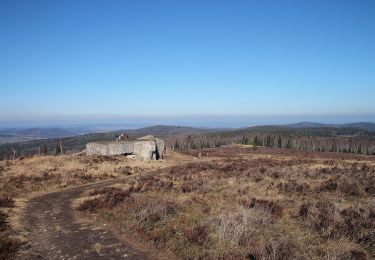
Trail On foot of 5.3 km to be discovered at Central Bohemia, Unknown, Zaječov. This trail is proposed by SityTrail - itinéraires balisés pédestres.
Trail created by cz:KČT.
09/2016 úsek K letišti - Dlouhý vrch není kompletní značení, Dlouhý vrch není rozcestník
![Trail On foot Zaječov - [Z] Dolní Kvaň - Dlouhý vrch - Photo 1](https://media.geolcdn.com/t/2048/auto/60865298-9d02-4cef-8983-cada33579dee.jpeg&format=jpg&maxdim=0 "Trail On foot Zaječov - [Z] Dolní Kvaň - Dlouhý vrch - Photo 1")
![Trail On foot Zaječov - [Z] Dolní Kvaň - Dlouhý vrch - Photo 2](https://media.geolcdn.com/t/2048/auto/35615d15-7b1f-4a46-9324-d9ed86e2c87c.jpeg&format=jpg&maxdim=0 "Trail On foot Zaječov - [Z] Dolní Kvaň - Dlouhý vrch - Photo 2")
![Trail On foot Zaječov - [Z] Dolní Kvaň - Dlouhý vrch - Photo 3](https://media.geolcdn.com/t/2048/auto/10dc4a26-fc2e-40d9-97ef-d1e464c8be7d.jpeg&format=jpg&maxdim=0 "Trail On foot Zaječov - [Z] Dolní Kvaň - Dlouhý vrch - Photo 3")
![Trail On foot Zaječov - [Z] Dolní Kvaň - Dlouhý vrch - Photo 4](https://media.geolcdn.com/t/2048/auto/586f4f60-57cb-4907-b68b-8c7cdf376bb3.jpeg&format=jpg&maxdim=0 "Trail On foot Zaječov - [Z] Dolní Kvaň - Dlouhý vrch - Photo 4")
![Trail On foot Zaječov - [Z] Dolní Kvaň - Dlouhý vrch - Photo 5](https://media.geolcdn.com/t/2048/auto/e7e94d6a-38a9-41b7-9c61-4b5e41f5448c.jpeg&format=jpg&maxdim=0 "Trail On foot Zaječov - [Z] Dolní Kvaň - Dlouhý vrch - Photo 5")
![Trail On foot Zaječov - [Z] Dolní Kvaň - Dlouhý vrch - Photo 6](https://media.geolcdn.com/t/2048/auto/d9c11326-21f4-4bb3-9e88-34c1a8213137.jpeg&format=jpg&maxdim=0 "Trail On foot Zaječov - [Z] Dolní Kvaň - Dlouhý vrch - Photo 6")
![Trail On foot Zaječov - [Z] Dolní Kvaň - Dlouhý vrch - Photo 7](https://media.geolcdn.com/t/2048/auto/2e81770d-d8d6-4ec2-a82a-a299852c0d0d.jpeg&format=jpg&maxdim=0 "Trail On foot Zaječov - [Z] Dolní Kvaň - Dlouhý vrch - Photo 7")
![Trail On foot Zaječov - [Z] Dolní Kvaň - Dlouhý vrch - Photo 8](https://media.geolcdn.com/t/2048/auto/0ecf5200-981c-454b-aa31-b7d0aef53c4b.jpeg&format=jpg&maxdim=0 "Trail On foot Zaječov - [Z] Dolní Kvaň - Dlouhý vrch - Photo 8")
![Trail On foot Zaječov - [Z] Dolní Kvaň - Dlouhý vrch - Photo 9](https://media.geolcdn.com/t/2048/auto/2917b9f3-6ded-4491-a155-7371cc376a20.jpeg&format=jpg&maxdim=0 "Trail On foot Zaječov - [Z] Dolní Kvaň - Dlouhý vrch - Photo 9")
![Trail On foot Zaječov - [Z] Dolní Kvaň - Dlouhý vrch - Photo 10](https://media.geolcdn.com/t/2048/auto/561bc882-a328-4ea0-8534-a2cb9c7ea26e.jpeg&format=jpg&maxdim=0 "Trail On foot Zaječov - [Z] Dolní Kvaň - Dlouhý vrch - Photo 10")
![Trail On foot Zaječov - [Ž] Svatá Dobrotivá - Kařízek - Photo](https://media.geolcdn.com/t/375/260/e689d382-4d8c-4668-997a-46922ae34690.jpeg&format=jpg&maxdim=2)
On foot
![Trail On foot Zaječov - [Ž] Strašice - Svatá Dobrotivá - Photo](https://media.geolcdn.com/t/375/260/50055e21-f702-4aa6-a720-57373c831aaf.jpeg&format=jpg&maxdim=2)
On foot
On foot
![Trail On foot Malá Víska - [M] K letišti - U Šraňku - Photo](https://media.geolcdn.com/t/375/260/3c02320c-0365-4613-b160-4eccc93fe97a.jpeg&format=jpg&maxdim=2)
On foot
![Trail On foot Zaječov - [M] Svatá Dobrotivá - Jinecká Baština - Photo](https://media.geolcdn.com/t/375/260/95743070-4377-4cd6-b1fb-a3d2ccd0ea74.jpeg&format=jpg&maxdim=2)
On foot
![Trail On foot Obecnice - [Z] Křesín - Dlouhý kámen - Photo](https://media.geolcdn.com/t/375/260/a0381e44-f2e0-4d28-a412-1a9454739cbf.jpeg&format=jpg&maxdim=2)
On foot
![Trail On foot Chaloupky - [Ž] Chaloupky - U Bílého křížku - Photo](https://media.geolcdn.com/t/375/260/e7e94d6a-38a9-41b7-9c61-4b5e41f5448c.jpeg&format=jpg&maxdim=2)
On foot
On foot