Trail On foot Nýrsko - NS Po stopách starých formanů - Photo

NS Po stopách starých formanů

Tous les sentiers balisés d’Europe GUIDE+

© OpenStreetMap contributors
Length
Length
19.7 km
Max alt
Max alt
697 m
Uphill gradient
Uphill gradient
449 m
Km-Effort
Km-Effort  
26 km
Min alt
Min alt
457 m
Downhill gradient
Downhill gradient
451 m
Boucle
Boucle
Yes
Signpost
Signpost
Creation date :
2025-02-07 14:02:09.515
Updated on :
2025-02-07 14:02:09.515

(0 Reviews)

On foot
On foot
5h50
Difficulty : Medium

Scan this QR Code to open this trail in the SityTrail application

FREE GPS app for hiking

Logo SityTrail SityTrail

IGN / Geographical institutes

Download SityTrail from the App Store Download SityTrail from Google Play

Logo SityTrail SityTrail World

The world is yours!

Download SityTrail from the App Store Download SityTrail from Google Play Download SityTrail on Huawei AppGallery

About

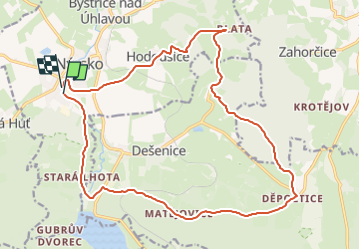
Trail On foot of 19.7 km to be discovered at Southwest, Plzeňský kraj, Nýrsko. This trail is proposed by SityTrail - itinéraires balisés pédestres.

Description

Trail created by Městys Dešenice.

Elevation profile

Photos

Positioning

Country:
Czech Republic
Region :
Southwest
Department/Province :
Plzeňský kraj
Municipality :
Nýrsko
Location:
Unknown
Start:(UTM)
364609 ; 5461040 (33U) N.

Trails nearby

Trail On foot Dešenice - [Ž] Větrovec - Hamry - Photo
On foot
GUIDE+

On foot

Easy
Dešenice, Southwest, Plzeňský kraj, Czech Republic
8 km | 11.6 km-effort
2h 38min
No
Trail On foot Dešenice - [Ž] Děšenice - pod Prenetem - Photo
On foot
GUIDE+

On foot

Easy
Dešenice, Southwest, Plzeňský kraj, Czech Republic
5.3 km | 9.2 km-effort
2h 5min
No
Trail On foot Hamry - [M] Nýrsko - U Zadních chalup - Photo
On foot
GUIDE+

On foot

Easy
Hamry, Southwest, Plzeňský kraj, Czech Republic
7.8 km | 10.7 km-effort
2h 25min
No


Close
My subscriptions