


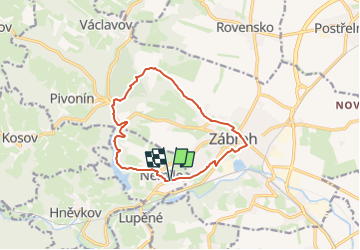

7.4 km | 11 km-effort

Tous les sentiers balisés d’Europe GUIDE+


FREE GPS app for hiking
 SityTrail
IGN / Geographical institutes
SityTrail World
The world is yours!
Trail On foot of 11 km to be discovered at Central Moravia, Olomouc Region, Nemile. This trail is proposed by SityTrail - itinéraires balisés pédestres.
Trail created by cz:KČT.


![Trail On foot Rapotín - [Ž] - Photo](https://media.geolcdn.com/t/375/260/ca426870-e86c-4a96-bde0-2f91190915ef.jpeg&format=jpg&maxdim=2)
On foot
![Trail On foot Rapotín - [M] - Photo](https://media.geolcdn.com/t/375/260/2389b978-f881-4d49-8011-c5e6270880f1.jpeg&format=jpg&maxdim=2)
On foot
On foot
On foot
On foot
![Trail On foot Tatenice - [M] Cukrová bouda - Tatenice - Photo](https://media.geolcdn.com/t/375/260/d7936ed9-d5a8-4f9e-8f62-c7c3895a88ed.jpeg&format=jpg&maxdim=2)
On foot

On foot
![Trail On foot Velké Losiny - [Ž] Potůčník - Šumperk - Photo](https://media.geolcdn.com/t/375/260/4a090c9a-e757-4d64-809d-5f91060e2f4a.jpeg&format=jpg&maxdim=2)
On foot
![Trail On foot Cotkytle - [Ž] Lanšperk-Mariánská hora - Photo](https://media.geolcdn.com/t/375/260/5d1ac99b-b532-46d6-b8e1-ac28f3b9033f.jpeg&format=jpg&maxdim=2)
On foot