Trail On foot Klučenice - NS Na Onen svět - Photo

Tous les sentiers balisés d’Europe GUIDE+

© OpenStreetMap contributors
Length
Length
68 km
Max alt
Max alt
632 m
Uphill gradient
Uphill gradient
1190 m
Km-Effort
Km-Effort  
84 km
Min alt
Min alt
352 m
Downhill gradient
Downhill gradient
1349 m
Boucle
Boucle
No
Signpost
Signpost
Creation date :
2025-02-07 13:13:21.549
Updated on :
2025-02-07 13:13:21.549

(0 Reviews)

On foot
On foot
19h10
Difficulty : Very difficult

Scan this QR Code to open this trail in the SityTrail application

FREE GPS app for hiking

Logo SityTrail SityTrail

IGN / Geographical institutes

Download SityTrail from the App Store Download SityTrail from Google Play

Logo SityTrail SityTrail World

The world is yours!

Download SityTrail from the App Store Download SityTrail from Google Play Download SityTrail on Huawei AppGallery

About

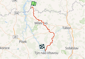
Trail On foot of 68 km to be discovered at Central Bohemia, Unknown, Klučenice. This trail is proposed by SityTrail - itinéraires balisés pédestres.

Description

Trail created by cz:KČT.

Elevation profile

Photos

Positioning

Country:
Czech Republic
Region :
Central Bohemia
Department/Province :
Unknown
Municipality :
Klučenice
Location:
Unknown
Start:(UTM)
444807 ; 5489832 (33U) N.

Trails nearby

Trail On foot Kovářov - [Č] Radava-Onen svět - Photo
On foot
GUIDE+

On foot

Easy
Kovářov, Southwest, Jihočeský kraj, Czech Republic
10 km | 12 km-effort
2h 44min
No
Trail On foot Kovářov - NS Kovářovsko - Photo
On foot
GUIDE+

On foot

Medium
Kovářov, Southwest, Jihočeský kraj, Czech Republic
19.4 km | 24 km-effort
5h 32min
Yes


Close
My subscriptions