


13.5 km | 16.6 km-effort
![Trail On foot Benešov - [Č] Konopiště, okružní trasa - Photo](https://media.geolcdn.com/t/1900/400/eef819f5-eaef-45e1-82ea-e15eb10f81b9.jpeg&format=pjpeg&maxdim=2)

Tous les sentiers balisés d’Europe GUIDE+


FREE GPS app for hiking
 SityTrail
IGN / Geographical institutes
SityTrail World
The world is yours!
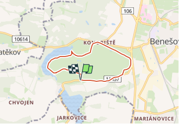
Trail On foot of 5.3 km to be discovered at Central Bohemia, Unknown, Benešov. This trail is proposed by SityTrail - itinéraires balisés pédestres.
Trail created by cz:KČT.
![Trail On foot Benešov - [Č] Konopiště, okružní trasa - Photo 1](https://media.geolcdn.com/t/2048/auto/065b5ec4-2f9f-4114-b668-76f199611a00.jpeg&format=jpg&maxdim=0 "Trail On foot Benešov - [Č] Konopiště, okružní trasa - Photo 1")
![Trail On foot Benešov - [Č] Konopiště, okružní trasa - Photo 2](https://media.geolcdn.com/t/2048/auto/cc8a7126-33af-4751-9096-d7fa8e873f63.jpeg&format=jpg&maxdim=0 "Trail On foot Benešov - [Č] Konopiště, okružní trasa - Photo 2")
![Trail On foot Benešov - [Č] Konopiště, okružní trasa - Photo 3](https://media.geolcdn.com/t/2048/auto/88bc4c0c-545c-43a5-85f4-c2c536b16fd5.jpeg&format=jpg&maxdim=0 "Trail On foot Benešov - [Č] Konopiště, okružní trasa - Photo 3")
![Trail On foot Benešov - [Č] Konopiště, okružní trasa - Photo 4](https://media.geolcdn.com/t/2048/auto/6b3898bd-db54-487a-af49-9f1c315fef3c.jpeg&format=jpg&maxdim=0 "Trail On foot Benešov - [Č] Konopiště, okružní trasa - Photo 4")
![Trail On foot Benešov - [Č] Konopiště, okružní trasa - Photo 5](https://media.geolcdn.com/t/2048/auto/c04328a7-1285-41cb-8f3b-7a0582901bdc.jpeg&format=jpg&maxdim=0 "Trail On foot Benešov - [Č] Konopiště, okružní trasa - Photo 5")
![Trail On foot Benešov - [Č] Konopiště, okružní trasa - Photo 6](https://media.geolcdn.com/t/2048/auto/a3daec66-efaa-4067-b9b1-2b946582a848.jpeg&format=jpg&maxdim=0 "Trail On foot Benešov - [Č] Konopiště, okružní trasa - Photo 6")
![Trail On foot Benešov - [Č] Konopiště, okružní trasa - Photo 7](https://media.geolcdn.com/t/2048/auto/495af9f4-6ae6-48a4-96e4-4014169d67ab.jpeg&format=jpg&maxdim=0 "Trail On foot Benešov - [Č] Konopiště, okružní trasa - Photo 7")
![Trail On foot Benešov - [Č] Konopiště, okružní trasa - Photo 8](https://media.geolcdn.com/t/2048/auto/8434ec24-eef2-4be5-907b-574d6d80be8d.jpeg&format=jpg&maxdim=0 "Trail On foot Benešov - [Č] Konopiště, okružní trasa - Photo 8")
![Trail On foot Benešov - [Č] Konopiště, okružní trasa - Photo 9](https://media.geolcdn.com/t/2048/auto/3b0fd53a-32e0-4a6b-ab38-25eb40f03fe2.jpeg&format=jpg&maxdim=0 "Trail On foot Benešov - [Č] Konopiště, okružní trasa - Photo 9")
![Trail On foot Benešov - [Č] Konopiště, okružní trasa - Photo 10](https://media.geolcdn.com/t/2048/auto/eef819f5-eaef-45e1-82ea-e15eb10f81b9.jpeg&format=jpg&maxdim=0 "Trail On foot Benešov - [Č] Konopiště, okružní trasa - Photo 10")
![Trail On foot Benešov - [Ž] Benešov - Týnec n. Sázavou - Photo](https://media.geolcdn.com/t/375/260/a945f703-f7b0-46ec-baf8-bf941e8d859d.jpeg&format=jpg&maxdim=2)
On foot

Walking