Trail On foot Ražice - NS Řežabinec - Photo

Tous les sentiers balisés d’Europe GUIDE+

© OpenStreetMap contributors
Length
Length
3.1 km
Max alt
Max alt
381 m
Uphill gradient
Uphill gradient
15 m
Km-Effort
Km-Effort  
3.3 km
Min alt
Min alt
370 m
Downhill gradient
Downhill gradient
15 m
Boucle
Boucle
No
Signpost
Signpost
Creation date :
2025-02-07 12:55:54.653
Updated on :
2025-02-07 12:55:54.653

(0 Reviews)

On foot
On foot
44m
Difficulty : Easy

Scan this QR Code to open this trail in the SityTrail application

FREE GPS app for hiking

Logo SityTrail SityTrail

IGN / Geographical institutes

Download SityTrail from the App Store Download SityTrail from Google Play

Logo SityTrail SityTrail World

The world is yours!

Download SityTrail from the App Store Download SityTrail from Google Play Download SityTrail on Huawei AppGallery

About

Trail On foot of 3.1 km to be discovered at Southwest, Jihočeský kraj, Ražice. This trail is proposed by SityTrail - itinéraires balisés pédestres.

Description

Trail created by cz:KČT.

Elevation profile

Photos

Positioning

Country:
Czech Republic
Region :
Southwest
Department/Province :
Jihočeský kraj
Municipality :
Ražice
Location:
Unknown
Start:(UTM)
435151 ; 5455069 (33U) N.

Trails nearby

Trail On foot Písek - NS Školní polesí - Hůrka - Photo
On foot
GUIDE+

On foot

Easy
Písek, Southwest, Jihočeský kraj, Czech Republic
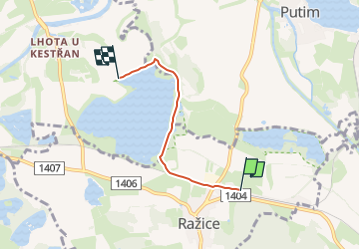
9.5 km | 12 km-effort
2h 43min
Yes
Trail On foot Písek - [M] Smrkovice - Protivín - Photo
On foot
GUIDE+

On foot

Easy
Písek, Southwest, Jihočeský kraj, Czech Republic
9.5 km | 11.3 km-effort
2h 34min
No
Trail On foot Putim - [Č] Putim - Písek - Photo
On foot
GUIDE+

On foot

Easy
Putim, Southwest, Jihočeský kraj, Czech Republic
9.2 km | 10.7 km-effort
2h 26min
No
Trail On foot Putim - [Z] Putim - Žižkova mohyla u Sudoměře - Photo
On foot
GUIDE+

On foot

Easy
Putim, Southwest, Jihočeský kraj, Czech Republic
7.2 km | 8.1 km-effort
1h 50min
No


Close
My subscriptions