Trail On foot Rudolfov - NS Člověk a krajina - Photo

Tous les sentiers balisés d’Europe GUIDE+

© OpenStreetMap contributors
Length
Length
6.3 km
Max alt
Max alt
481 m
Uphill gradient
Uphill gradient
35 m
Km-Effort
Km-Effort  
7 km
Min alt
Min alt
392 m
Downhill gradient
Downhill gradient
121 m
Boucle
Boucle
No
Signpost
Signpost
Creation date :
2025-02-07 12:41:32.663
Updated on :
2025-02-07 12:41:32.663

(0 Reviews)

On foot
On foot
1h35
Difficulty : Easy

Scan this QR Code to open this trail in the SityTrail application

FREE GPS app for hiking

Logo SityTrail SityTrail

IGN / Geographical institutes

Download SityTrail from the App Store Download SityTrail from Google Play

Logo SityTrail SityTrail World

The world is yours!

Download SityTrail from the App Store Download SityTrail from Google Play Download SityTrail on Huawei AppGallery

About

Trail On foot of 6.3 km to be discovered at Southwest, Jihočeský kraj, Rudolfov. This trail is proposed by SityTrail - itinéraires balisés pédestres.

Description

Trail created by cz:KČT.

Elevation profile

Photos

Positioning

Country:
Czech Republic
Region :
Southwest
Department/Province :
Jihočeský kraj
Municipality :
Rudolfov
Location:
Unknown
Start:(UTM)
466492 ; 5426870 (33U) N.

Trails nearby

Trail On foot Rudolfov - NS Cesta kolem hornického města - Photo
On foot
GUIDE+

On foot

Easy
Rudolfov, Southwest, Jihočeský kraj, Czech Republic
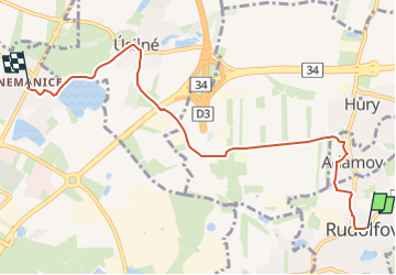
5.2 km | 6.6 km-effort
1h 30min
No
Trail On foot Libníč - [Ž] Lišov náměstí - U Libniče - Photo
On foot
GUIDE+

On foot

Easy
Libníč, Southwest, Jihočeský kraj, Czech Republic
5.4 km | 6.8 km-effort
1h 32min
No


Close
My subscriptions