


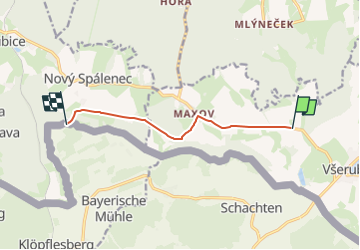

12.3 km | 16.8 km-effort
![Trail On foot Všeruby - [Ž] u bývalého Myslíva - Spálenec - Photo](https://media.geolcdn.com/t/1900/400/87e14372-60f2-4a7e-92aa-f004b8352505.jpeg&format=pjpeg&maxdim=2)

Tous les sentiers balisés d’Europe GUIDE+


FREE GPS app for hiking
 SityTrail
IGN / Geographical institutes
SityTrail World
The world is yours!
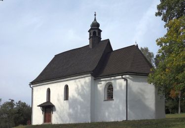
Trail On foot of 6.3 km to be discovered at Southwest, Plzeňský kraj, Všeruby. This trail is proposed by SityTrail - itinéraires balisés pédestres.
Trail created by cz:KČT.
![Trail On foot Všeruby - [Ž] u bývalého Myslíva - Spálenec - Photo 1](https://media.geolcdn.com/t/2048/auto/88c7e913-c89e-4ebc-abbc-e9bf1b2f9e8e.jpeg&format=jpg&maxdim=0 "Trail On foot Všeruby - [Ž] u bývalého Myslíva - Spálenec - Photo 1")
![Trail On foot Všeruby - [Ž] u bývalého Myslíva - Spálenec - Photo 2](https://media.geolcdn.com/t/2048/auto/782d464a-516a-4652-8236-fd12bd227f3c.jpeg&format=jpg&maxdim=0 "Trail On foot Všeruby - [Ž] u bývalého Myslíva - Spálenec - Photo 2")
![Trail On foot Všeruby - [Ž] u bývalého Myslíva - Spálenec - Photo 3](https://media.geolcdn.com/t/2048/auto/b7f9b127-f2ea-4710-9004-7a729ab50379.jpeg&format=jpg&maxdim=0 "Trail On foot Všeruby - [Ž] u bývalého Myslíva - Spálenec - Photo 3")
![Trail On foot Všeruby - [Ž] u bývalého Myslíva - Spálenec - Photo 4](https://media.geolcdn.com/t/2048/auto/2461646e-d979-4814-8337-ba5585565e19.jpeg&format=jpg&maxdim=0 "Trail On foot Všeruby - [Ž] u bývalého Myslíva - Spálenec - Photo 4")
![Trail On foot Všeruby - [Ž] u bývalého Myslíva - Spálenec - Photo 5](https://media.geolcdn.com/t/2048/auto/81337500-6861-4551-9c3d-677e901695d3.jpeg&format=jpg&maxdim=0 "Trail On foot Všeruby - [Ž] u bývalého Myslíva - Spálenec - Photo 5")
![Trail On foot Všeruby - [Ž] u bývalého Myslíva - Spálenec - Photo 6](https://media.geolcdn.com/t/2048/auto/406c8e77-aa4f-41ce-b057-d590bf7c1b95.jpeg&format=jpg&maxdim=0 "Trail On foot Všeruby - [Ž] u bývalého Myslíva - Spálenec - Photo 6")
![Trail On foot Všeruby - [Ž] u bývalého Myslíva - Spálenec - Photo 7](https://media.geolcdn.com/t/2048/auto/5cfb2d95-7927-48a7-baf9-1cd771914e39.jpeg&format=jpg&maxdim=0 "Trail On foot Všeruby - [Ž] u bývalého Myslíva - Spálenec - Photo 7")
![Trail On foot Všeruby - [Ž] u bývalého Myslíva - Spálenec - Photo 8](https://media.geolcdn.com/t/2048/auto/8f71ce21-0a27-4d2b-8c07-c06dffc33514.jpeg&format=jpg&maxdim=0 "Trail On foot Všeruby - [Ž] u bývalého Myslíva - Spálenec - Photo 8")
![Trail On foot Všeruby - [Ž] u bývalého Myslíva - Spálenec - Photo 9](https://media.geolcdn.com/t/2048/auto/8790d4a2-4a9d-4f3e-84a8-82fc75df99bb.jpeg&format=jpg&maxdim=0 "Trail On foot Všeruby - [Ž] u bývalého Myslíva - Spálenec - Photo 9")
![Trail On foot Všeruby - [Ž] u bývalého Myslíva - Spálenec - Photo 10](https://media.geolcdn.com/t/2048/auto/87e14372-60f2-4a7e-92aa-f004b8352505.jpeg&format=jpg&maxdim=0 "Trail On foot Všeruby - [Ž] u bývalého Myslíva - Spálenec - Photo 10")
On foot