


12.6 km | 17.6 km-effort
![Trail On foot Rybník - [M] Rybník - Rybník CZ/D - Photo](https://media.geolcdn.com/t/1900/400/3e72288d-7700-4a27-9695-4c0fe2037764.jpeg&format=pjpeg&maxdim=2)

Tous les sentiers balisés d’Europe GUIDE+


FREE GPS app for hiking
 SityTrail
IGN / Geographical institutes
SityTrail World
The world is yours!
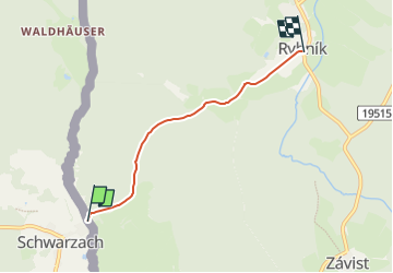
Trail On foot of 3.5 km to be discovered at Southwest, Plzeňský kraj, Rybník. This trail is proposed by SityTrail - itinéraires balisés pédestres.
Trail created by cz:KČT.
![Trail On foot Rybník - [M] Rybník - Rybník CZ/D - Photo 1](https://media.geolcdn.com/t/2048/auto/8def90d2-a502-4a37-aabf-584cfcf5a930.jpeg&format=jpg&maxdim=0 "Trail On foot Rybník - [M] Rybník - Rybník CZ/D - Photo 1")
![Trail On foot Rybník - [M] Rybník - Rybník CZ/D - Photo 2](https://media.geolcdn.com/t/2048/auto/4c60bd27-56e2-4e6e-a37d-9417431ebed8.jpeg&format=jpg&maxdim=0 "Trail On foot Rybník - [M] Rybník - Rybník CZ/D - Photo 2")
![Trail On foot Rybník - [M] Rybník - Rybník CZ/D - Photo 3](https://media.geolcdn.com/t/2048/auto/68663bf5-df19-4da6-93bb-99fa208d8202.jpeg&format=jpg&maxdim=0 "Trail On foot Rybník - [M] Rybník - Rybník CZ/D - Photo 3")
![Trail On foot Rybník - [M] Rybník - Rybník CZ/D - Photo 4](https://media.geolcdn.com/t/2048/auto/4028f2a5-8be7-4c08-aa44-aef3ba7c6e5c.jpeg&format=jpg&maxdim=0 "Trail On foot Rybník - [M] Rybník - Rybník CZ/D - Photo 4")
![Trail On foot Rybník - [M] Rybník - Rybník CZ/D - Photo 5](https://media.geolcdn.com/t/2048/auto/f16e473b-08d1-41ab-86f0-8b2624cbaf46.jpeg&format=jpg&maxdim=0 "Trail On foot Rybník - [M] Rybník - Rybník CZ/D - Photo 5")
![Trail On foot Rybník - [M] Rybník - Rybník CZ/D - Photo 6](https://media.geolcdn.com/t/2048/auto/b621b3ba-f6ca-457a-b439-2d88f5ed03dd.jpeg&format=jpg&maxdim=0 "Trail On foot Rybník - [M] Rybník - Rybník CZ/D - Photo 6")
![Trail On foot Rybník - [M] Rybník - Rybník CZ/D - Photo 7](https://media.geolcdn.com/t/2048/auto/1d4ee4f6-373f-40aa-bf2b-1775c5d38d1b.jpeg&format=jpg&maxdim=0 "Trail On foot Rybník - [M] Rybník - Rybník CZ/D - Photo 7")
![Trail On foot Rybník - [M] Rybník - Rybník CZ/D - Photo 8](https://media.geolcdn.com/t/2048/auto/4a4bae0e-5e35-4a16-a3b8-67ae2c274de1.jpeg&format=jpg&maxdim=0 "Trail On foot Rybník - [M] Rybník - Rybník CZ/D - Photo 8")
![Trail On foot Rybník - [M] Rybník - Rybník CZ/D - Photo 9](https://media.geolcdn.com/t/2048/auto/4aad87fb-f6a3-4423-b025-16b00b41136f.jpeg&format=jpg&maxdim=0 "Trail On foot Rybník - [M] Rybník - Rybník CZ/D - Photo 9")
![Trail On foot Rybník - [M] Rybník - Rybník CZ/D - Photo 10](https://media.geolcdn.com/t/2048/auto/3e72288d-7700-4a27-9695-4c0fe2037764.jpeg&format=jpg&maxdim=0 "Trail On foot Rybník - [M] Rybník - Rybník CZ/D - Photo 10")
On foot
On foot
On foot

On foot