![](/images/other/stat-length.png)
![Trail On foot Třemošná - Okružní naučná stezka Třemošná - Photo](https://media.geolcdn.com/t/1900/400/f2045bf7-f9a0-4513-bf38-d03444b060af.jpeg&format=pjpeg&maxdim=2)
Okružní naučná stezka Třemošná
SityTrail - itinéraires balisés pédestres
Tous les sentiers balisés d’Europe GUIDE+
![Length](/images/other/stat-length.png)
Length
10.6 km
![Max alt](https://static1.geolcdn.com/siteimages/upload/files/1508320355ic_sort_altitude_max_24dp.png)
Max alt
410 m
![Uphill gradient](https://static1.geolcdn.com/siteimages/upload/files/1508320355ic_sort_den_pos_24dp.png)
Uphill gradient
164 m
![Km-Effort](/images/other/stat-length.png)
Km-Effort
12.7 km
![Min alt](https://static1.geolcdn.com/siteimages/upload/files/1508320355ic_sort_altitude_min_24dp.png)
Min alt
332 m
![Downhill gradient](https://static1.geolcdn.com/siteimages/upload/files/1508320355ic_sort_den_neg_24dp.png)
Downhill gradient
163 m
![Boucle](https://static1.geolcdn.com/siteimages/upload/files/16400158638029165_repeat_loop_refresh_sync_direction_icon.png)
Boucle
Yes
Signpost
Creation date :
2025-02-07 12:16:38.644
Updated on :
2025-02-07 12:16:38.644
![On foot](https://static1.geolcdn.com/sitytour/trail-icons/100.png)
2h53
Difficulty : Easy
![Scan this QR Code to open this trail in the SityTrail application](https://capi.geolives.com/qq0zvz2zws4bq2lad0pu/sitytour/trails/4345548/qr.png?size=200)
FREE GPS app for hiking
About
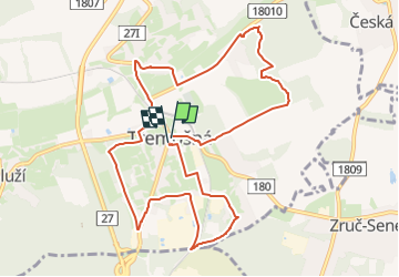
Trail On foot of 10.6 km to be discovered at Southwest, Plzeňský kraj, Třemošná. This trail is proposed by SityTrail - itinéraires balisés pédestres.
Description
Website: http://turista.tatran-tremosna.cz/naucna_stezka.htm
Positioning
Country:
Czech Republic
Region :
Southwest
Department/Province :
Plzeňský kraj
Municipality :
Třemošná
Location:
Unknown
Start:(Dec)
Start:(UTM)
384566 ; 5519491 (33U) N.
Comments
Trails nearby
![Trail On foot Třemošná - [Č] Senný dolík - Záluží - Photo](https://media.geolcdn.com/t/375/260/877b0f0e-da18-4148-9dd1-298e2e587c5d.jpeg&format=jpg&maxdim=2)
![On foot On foot](https://static1.geolcdn.com/sitytour/trail-icons/100.png)
[Č] Senný dolík - Záluží
On foot
Easy
Třemošná,
Southwest,
Plzeňský kraj,
Czech Republic
![](/images/other/stat-length.png)
16 km | 19.6 km-effort
4h 27min
![](https://static1.geolcdn.com/siteimages/upload/files/16400158638029165_repeat_loop_refresh_sync_direction_icon.png)
No
![Trail On foot Hromnice - [Z] trojúhelník - Photo](https://media.geolcdn.com/t/375/260/8244e9d1-3a7b-4319-ab21-6ff4aac17b89.jpeg&format=jpg&maxdim=2)
![On foot On foot](https://static1.geolcdn.com/sitytour/trail-icons/100.png)
[Z] trojúhelník
On foot
Easy
Hromnice,
Southwest,
Plzeňský kraj,
Czech Republic
![](/images/other/stat-length.png)
6.1 km | 7.8 km-effort
1h 45min
![](https://static1.geolcdn.com/siteimages/upload/files/16400158638029165_repeat_loop_refresh_sync_direction_icon.png)
No
![Trail On foot Zruč-Senec - [M] trojúhelník - Photo](https://media.geolcdn.com/t/375/260/2fd79879-0666-4aef-bdf3-72361d456ac1.jpeg&format=jpg&maxdim=2)
![On foot On foot](https://static1.geolcdn.com/sitytour/trail-icons/100.png)
[M] trojúhelník
On foot
Easy
Zruč-Senec,
Southwest,
Plzeňský kraj,
Czech Republic
![](/images/other/stat-length.png)
8 km | 10 km-effort
2h 16min
![](https://static1.geolcdn.com/siteimages/upload/files/16400158638029165_repeat_loop_refresh_sync_direction_icon.png)
No
![Trail On foot Ledce - [Z] trojúhelník - Photo](https://media.geolcdn.com/t/375/260/c688db8e-921c-45c7-bf19-290c8542ad17.jpeg&format=jpg&maxdim=2)
![On foot On foot](https://static1.geolcdn.com/sitytour/trail-icons/100.png)
[Z] trojúhelník
On foot
Easy
Ledce,
Southwest,
Plzeňský kraj,
Czech Republic
![](/images/other/stat-length.png)
5.6 km | 6.6 km-effort
1h 29min
![](https://static1.geolcdn.com/siteimages/upload/files/16400158638029165_repeat_loop_refresh_sync_direction_icon.png)
No
![Trail On foot Plzeň - Sigmondova okružní naučná stezka - Photo](https://media.geolcdn.com/t/375/260/781fdee0-37fe-4640-9de5-eeaac1f1fda2.jpeg&format=jpg&maxdim=2)
![On foot On foot](https://static1.geolcdn.com/sitytour/trail-icons/100.png)
Sigmondova okružní naučná stezka
On foot
Easy
Plzeň,
Southwest,
Plzeňský kraj,
Czech Republic
![](/images/other/stat-length.png)
7.1 km | 8.6 km-effort
1h 57min
![](https://static1.geolcdn.com/siteimages/upload/files/16400158638029165_repeat_loop_refresh_sync_direction_icon.png)
Yes