Trail On foot Albrechtice - NS Údolí Moravské Sázavy - Photo

NS Údolí Moravské Sázavy

Tous les sentiers balisés d’Europe GUIDE+

© OpenStreetMap contributors
Length
Length
5.5 km
Max alt
Max alt
515 m
Uphill gradient
Uphill gradient
161 m
Km-Effort
Km-Effort  
7.3 km
Min alt
Min alt
405 m
Downhill gradient
Downhill gradient
66 m
Boucle
Boucle
No
Signpost
Signpost
Creation date :
2025-02-07 12:02:58.963
Updated on :
2025-02-07 12:02:58.963

(0 Reviews)

On foot
On foot
1h39
Difficulty : Easy

Scan this QR Code to open this trail in the SityTrail application

FREE GPS app for hiking

Logo SityTrail SityTrail

IGN / Geographical institutes

Download SityTrail from the App Store Download SityTrail from Google Play

Logo SityTrail SityTrail World

The world is yours!

Download SityTrail from the App Store Download SityTrail from Google Play Download SityTrail on Huawei AppGallery

About

Trail On foot of 5.5 km to be discovered at Northeast, Pardubický kraj, Albrechtice. This trail is proposed by SityTrail - itinéraires balisés pédestres.

Description

Trail created by cz:KČT.

Elevation profile

Photos

Positioning

Country:
Czech Republic
Region :
Northeast
Department/Province :
Pardubický kraj
Municipality :
Albrechtice
Location:
Unknown
Start:(UTM)
617879 ; 5532919 (33U) N.

Trails nearby

Trail On foot Cotkytle - [Ž] Lanšperk-Mariánská hora - Photo
On foot
GUIDE+

On foot

Difficult
Cotkytle, Northeast, Pardubický kraj, Czech Republic
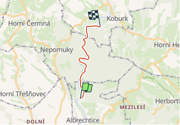
27 km | 36 km-effort
8h 14min
No
Trail On foot Lanškroun - [Ž] vycházkový okruh Obora - Photo
On foot
GUIDE+

On foot

Easy
Lanškroun, Northeast, Pardubický kraj, Czech Republic
7.5 km | 9.1 km-effort
2h 3min
No
Trail On foot Horní Čermná - [M] Lanškroun - Mariánská hora - Photo
On foot
GUIDE+

On foot

Easy
Horní Čermná, Northeast, Pardubický kraj, Czech Republic
7.1 km | 8.1 km-effort
1h 50min
No


Close
My subscriptions