![](/images/other/stat-length.png)
![Trail Walking Millau - SityTrail - 4343761 - st-martin-du-larzac_06022025 - Photo](https://media.geolcdn.com/t/1900/400/ext.pjpeg?maxdim=2&url=https%3A%2F%2Fstatic1.geolcdn.com%2Fsiteimages%2Fupload%2Ffiles%2F1553511878bg_sport_marche.png)
SityTrail - 4343761 - st-martin-du-larzac_06022025
mamyln
User
![Length](/images/other/stat-length.png)
Length
15.3 km
![Max alt](https://static1.geolcdn.com/siteimages/upload/files/1508320355ic_sort_altitude_max_24dp.png)
Max alt
814 m
![Uphill gradient](https://static1.geolcdn.com/siteimages/upload/files/1508320355ic_sort_den_pos_24dp.png)
Uphill gradient
252 m
![Km-Effort](/images/other/stat-length.png)
Km-Effort
18.7 km
![Min alt](https://static1.geolcdn.com/siteimages/upload/files/1508320355ic_sort_altitude_min_24dp.png)
Min alt
654 m
![Downhill gradient](https://static1.geolcdn.com/siteimages/upload/files/1508320355ic_sort_den_neg_24dp.png)
Downhill gradient
251 m
![Boucle](https://static1.geolcdn.com/siteimages/upload/files/16400158638029165_repeat_loop_refresh_sync_direction_icon.png)
Boucle
Yes
Creation date :
2025-02-07 11:56:26.367
Updated on :
2025-02-09 14:09:13.39
![Walking](https://static1.geolcdn.com/sitytour/trail-icons/101.png)
4h14
Difficulty : Difficult
![Scan this QR Code to open this trail in the SityTrail application](https://capi.geolives.com/qq0zvz2zws4bq2lad0pu/sitytour/trails/4345513/qr.png?size=200)
FREE GPS app for hiking
About
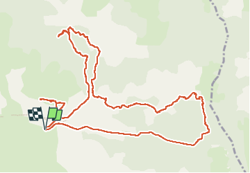
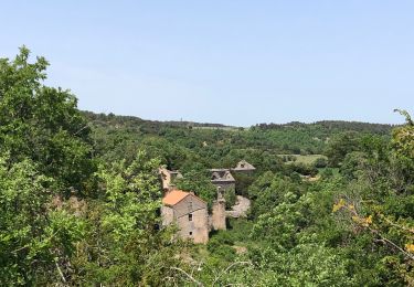
Trail Walking of 15.3 km to be discovered at Occitania, Aveyron, Millau. This trail is proposed by mamyln.
Description
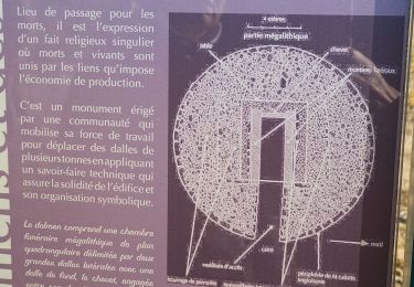
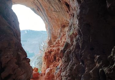
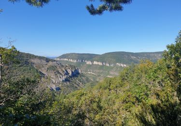
Cool, promenade sympathique : troglodytes, gros cailloux, source, hameaux, buissonnières (en mauvais état = buis morts)
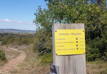
Seul bémol la fin du parcours : 2.5km de route, pourquoi ne pas tourner à droite au 12km retourner vers Jassenove, Les Baumes et St Martin du Larzac ?
Positioning
Country:
France
Region :
Occitania
Department/Province :
Aveyron
Municipality :
Millau
Location:
Unknown
Start:(Dec)
Start:(UTM)
513578 ; 4879809 (31T) N.
Comments
Trails nearby
![Trail Walking Millau - St Martin du Larzac_06022025 - Photo](https://media.geolcdn.com/t/375/260/ebeb1ea7-cd7c-4d88-8625-908181c795d9.jpg&format=jpg&maxdim=2)
![Walking Walking](https://static1.geolcdn.com/sitytour/trail-icons/101.png)
St Martin du Larzac_06022025
Walking
Difficult
Millau,
Occitania,
Aveyron,
France
![](/images/other/stat-length.png)
15.3 km | 18.7 km-effort
6h 25min
![](https://static1.geolcdn.com/siteimages/upload/files/16400158638029165_repeat_loop_refresh_sync_direction_icon.png)
Yes
![Trail Walking Millau - la jasse et la blasuiere - Photo](https://media.geolcdn.com/t/375/260/96e4ae4d-2c19-49a1-8dc2-ab52cd2e3ebb.jpg&format=jpg&maxdim=2)
![Walking Walking](https://static1.geolcdn.com/sitytour/trail-icons/101.png)
la jasse et la blasuiere
Walking
Medium
Millau,
Occitania,
Aveyron,
France
![](/images/other/stat-length.png)
15.6 km | 18.5 km-effort
3h 26min
![](https://static1.geolcdn.com/siteimages/upload/files/16400158638029165_repeat_loop_refresh_sync_direction_icon.png)
Yes
![Trail Walking Millau - Le cun nant - Photo](https://media.geolcdn.com/t/375/260/6e3d7c45-5abf-4932-8165-07abd9c5f4f1.jpg&format=jpg&maxdim=2)
![Walking Walking](https://static1.geolcdn.com/sitytour/trail-icons/101.png)
Le cun nant
Walking
Very difficult
Millau,
Occitania,
Aveyron,
France
![](/images/other/stat-length.png)
20 km | 27 km-effort
5h 15min
![](https://static1.geolcdn.com/siteimages/upload/files/16400158638029165_repeat_loop_refresh_sync_direction_icon.png)
No
![Trail Walking Millau - monna baume rouge - Photo](https://media.geolcdn.com/t/375/260/a8584174-41de-4dc9-89fd-a3a351c1c3e5.jpg&format=jpg&maxdim=2)
![Walking Walking](https://static1.geolcdn.com/sitytour/trail-icons/101.png)
monna baume rouge
Walking
Medium
Millau,
Occitania,
Aveyron,
France
![](/images/other/stat-length.png)
3.3 km | 6.3 km-effort
1h 9min
![](https://static1.geolcdn.com/siteimages/upload/files/16400158638029165_repeat_loop_refresh_sync_direction_icon.png)
Yes
![Trail Walking Millau - potensac in live - Photo](https://media.geolcdn.com/t/375/260/e823d3f9-43ca-498b-8c90-24c12175d9e7.jpg&format=jpg&maxdim=2)
![Walking Walking](https://static1.geolcdn.com/sitytour/trail-icons/101.png)
potensac in live
Walking
Medium
Millau,
Occitania,
Aveyron,
France
![](/images/other/stat-length.png)
16.7 km | 22 km-effort
3h 49min
![](https://static1.geolcdn.com/siteimages/upload/files/16400158638029165_repeat_loop_refresh_sync_direction_icon.png)
Yes
![Trail Walking Millau - 2019-08-23 Autour de JASSENOVE - Photo](https://media.geolcdn.com/t/375/260/52139849-c410-4df0-a510-2014291b78fd.jpg&format=jpg&maxdim=2)
![Walking Walking](https://static1.geolcdn.com/sitytour/trail-icons/101.png)
2019-08-23 Autour de JASSENOVE
Walking
Easy
Millau,
Occitania,
Aveyron,
France
![](/images/other/stat-length.png)
4.5 km | 5.8 km-effort
1h 24min
![](https://static1.geolcdn.com/siteimages/upload/files/16400158638029165_repeat_loop_refresh_sync_direction_icon.png)
Yes
![Trail Walking Millau - Millau (Saint Martin du Larzac) - Photo](https://media.geolcdn.com/t/375/260/ext.jpg?maxdim=2&url=https%3A%2F%2Fstatic1.geolcdn.com%2Fsiteimages%2Fupload%2Ffiles%2F1553511878bg_sport_marche.png)
![Walking Walking](https://static1.geolcdn.com/sitytour/trail-icons/101.png)
Millau (Saint Martin du Larzac)
Walking
Easy
Millau,
Occitania,
Aveyron,
France
![](/images/other/stat-length.png)
15.8 km | 18.3 km-effort
5h 29min
![](https://static1.geolcdn.com/siteimages/upload/files/16400158638029165_repeat_loop_refresh_sync_direction_icon.png)
Yes
![Trail Walking Millau - potensac - Photo](https://media.geolcdn.com/t/375/260/839dc2ae-7273-4279-950e-f2e9a16912d5.jpg&format=jpg&maxdim=2)
![Walking Walking](https://static1.geolcdn.com/sitytour/trail-icons/101.png)
![Trail Walking Millau - Larzac - Photo](https://media.geolcdn.com/t/375/260/ext.jpg?maxdim=2&url=https%3A%2F%2Fstatic1.geolcdn.com%2Fsiteimages%2Fupload%2Ffiles%2F1553511878bg_sport_marche.png)
![Walking Walking](https://static1.geolcdn.com/sitytour/trail-icons/101.png)