


5.1 km | 5.9 km-effort
![Trail On foot Kukle - [Č] Vozíčkářský okruh nad Rosničkou - Photo](https://media.geolcdn.com/t/1900/400/a09e8f9b-db43-4592-b8eb-0648f5280109.jpeg&format=pjpeg&maxdim=2)

Tous les sentiers balisés d’Europe GUIDE+


FREE GPS app for hiking
 SityTrail
IGN / Geographical institutes
SityTrail World
The world is yours!
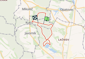
Trail On foot of 12 km to be discovered at Northeast, Pardubický kraj, Kukle. This trail is proposed by SityTrail - itinéraires balisés pédestres.
Trail created by cz:KČT.
![Trail On foot Kukle - [Č] Vozíčkářský okruh nad Rosničkou - Photo 1](https://media.geolcdn.com/t/2048/auto/251efa8f-0083-4e27-bcbc-dd97f072de57.jpeg&format=jpg&maxdim=0 "Trail On foot Kukle - [Č] Vozíčkářský okruh nad Rosničkou - Photo 1")
![Trail On foot Kukle - [Č] Vozíčkářský okruh nad Rosničkou - Photo 2](https://media.geolcdn.com/t/2048/auto/8e76206b-acd6-4c51-9c7d-aa6ffbd52a88.jpeg&format=jpg&maxdim=0 "Trail On foot Kukle - [Č] Vozíčkářský okruh nad Rosničkou - Photo 2")
![Trail On foot Kukle - [Č] Vozíčkářský okruh nad Rosničkou - Photo 3](https://media.geolcdn.com/t/2048/auto/e75c0ed7-590e-4e03-ab68-9f11c89bd61b.jpeg&format=jpg&maxdim=0 "Trail On foot Kukle - [Č] Vozíčkářský okruh nad Rosničkou - Photo 3")
![Trail On foot Kukle - [Č] Vozíčkářský okruh nad Rosničkou - Photo 4](https://media.geolcdn.com/t/2048/auto/65a8cad5-d317-4c60-b568-9a8a9df269bb.jpeg&format=jpg&maxdim=0 "Trail On foot Kukle - [Č] Vozíčkářský okruh nad Rosničkou - Photo 4")
![Trail On foot Kukle - [Č] Vozíčkářský okruh nad Rosničkou - Photo 5](https://media.geolcdn.com/t/2048/auto/9cd806ba-1cd9-478d-8b14-a3b875c929c0.jpeg&format=jpg&maxdim=0 "Trail On foot Kukle - [Č] Vozíčkářský okruh nad Rosničkou - Photo 5")
![Trail On foot Kukle - [Č] Vozíčkářský okruh nad Rosničkou - Photo 6](https://media.geolcdn.com/t/2048/auto/11558ddc-17eb-4046-ad04-3994cfefa0ae.jpeg&format=jpg&maxdim=0 "Trail On foot Kukle - [Č] Vozíčkářský okruh nad Rosničkou - Photo 6")
![Trail On foot Kukle - [Č] Vozíčkářský okruh nad Rosničkou - Photo 7](https://media.geolcdn.com/t/2048/auto/20b11d45-a939-42d5-aa1f-13508c6d972d.jpeg&format=jpg&maxdim=0 "Trail On foot Kukle - [Č] Vozíčkářský okruh nad Rosničkou - Photo 7")
![Trail On foot Kukle - [Č] Vozíčkářský okruh nad Rosničkou - Photo 8](https://media.geolcdn.com/t/2048/auto/cc22c80b-b88e-4752-b8bd-c37b4efeb9d9.jpeg&format=jpg&maxdim=0 "Trail On foot Kukle - [Č] Vozíčkářský okruh nad Rosničkou - Photo 8")
![Trail On foot Kukle - [Č] Vozíčkářský okruh nad Rosničkou - Photo 9](https://media.geolcdn.com/t/2048/auto/24df8b04-1abe-441d-9413-c0c91347940d.jpeg&format=jpg&maxdim=0 "Trail On foot Kukle - [Č] Vozíčkářský okruh nad Rosničkou - Photo 9")
![Trail On foot Kukle - [Č] Vozíčkářský okruh nad Rosničkou - Photo 10](https://media.geolcdn.com/t/2048/auto/a09e8f9b-db43-4592-b8eb-0648f5280109.jpeg&format=jpg&maxdim=0 "Trail On foot Kukle - [Č] Vozíčkářský okruh nad Rosničkou - Photo 10")
On foot
On foot