Trail On foot Řetová - NS Okolo Řetové - Photo

Tous les sentiers balisés d’Europe GUIDE+

© OpenStreetMap contributors
Length
Length
9.6 km
Max alt
Max alt
568 m
Uphill gradient
Uphill gradient
342 m
Km-Effort
Km-Effort  
14.1 km
Min alt
Min alt
401 m
Downhill gradient
Downhill gradient
339 m
Boucle
Boucle
Yes
Signpost
Signpost
Creation date :
2025-02-07 11:38:38.129
Updated on :
2025-02-07 11:38:38.129

(0 Reviews)

On foot
On foot
3h12
Difficulty : Easy

Scan this QR Code to open this trail in the SityTrail application

FREE GPS app for hiking

Logo SityTrail SityTrail

IGN / Geographical institutes

Download SityTrail from the App Store Download SityTrail from Google Play

Logo SityTrail SityTrail World

The world is yours!

Download SityTrail from the App Store Download SityTrail from Google Play Download SityTrail on Huawei AppGallery

About

Trail On foot of 9.6 km to be discovered at Northeast, Pardubický kraj, Řetová. This trail is proposed by SityTrail - itinéraires balisés pédestres.

Description

Trail created by cz:KČT.

Elevation profile

Photos

Positioning

Country:
Czech Republic
Region :
Northeast
Department/Province :
Pardubický kraj
Municipality :
Řetová
Location:
Unknown
Start:(UTM)
599068 ; 5533587 (33U) N.

Trails nearby

Trail On foot Orlické Podhůří - NS po stopách živé vody - Photo
On foot
GUIDE+

On foot

Easy
Orlické Podhůří, Northeast, Pardubický kraj, Czech Republic
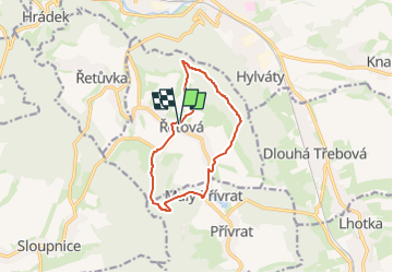
7.3 km | 10.8 km-effort
2h 27min
Yes
Trail On foot Přívrat - [Ž] Zhořský kopec - Pod Lysinou - Photo
On foot
GUIDE+

On foot

Easy
Přívrat, Northeast, Pardubický kraj, Czech Republic
15.3 km | 18.7 km-effort
4h 15min
No
Trail On foot Ústí nad Orlicí - [M] Česká Třebová-Ústí nad Orlicí - Photo
On foot
GUIDE+

On foot

Difficult
Ústí nad Orlicí, Northeast, Pardubický kraj, Czech Republic
25 km | 33 km-effort
7h 27min
No


Close
My subscriptions