


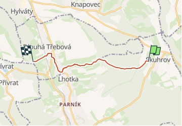

8 km | 11.2 km-effort
![Trail On foot Česká Třebová - [Ž] Pod Kozlovcem - Pod Skuhrovem - Photo](https://media.geolcdn.com/t/1900/400/e10c881f-a244-44ac-b766-3afd8215abfb.jpeg&format=pjpeg&maxdim=2)

Tous les sentiers balisés d’Europe GUIDE+


FREE GPS app for hiking
 SityTrail
IGN / Geographical institutes
SityTrail World
The world is yours!
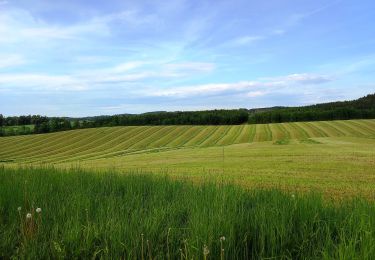
Trail On foot of 7 km to be discovered at Northeast, Pardubický kraj, Česká Třebová. This trail is proposed by SityTrail - itinéraires balisés pédestres.
Trail created by cz:KČT.
![Trail On foot Česká Třebová - [Ž] Pod Kozlovcem - Pod Skuhrovem - Photo 1](https://media.geolcdn.com/t/2048/auto/dd894b21-0470-42b5-a1d5-a7c1a3d56ac5.jpeg&format=jpg&maxdim=0 "Trail On foot Česká Třebová - [Ž] Pod Kozlovcem - Pod Skuhrovem - Photo 1")
![Trail On foot Česká Třebová - [Ž] Pod Kozlovcem - Pod Skuhrovem - Photo 2](https://media.geolcdn.com/t/2048/auto/bd94bd42-f774-47a9-823f-707e57eb4fed.jpeg&format=jpg&maxdim=0 "Trail On foot Česká Třebová - [Ž] Pod Kozlovcem - Pod Skuhrovem - Photo 2")
![Trail On foot Česká Třebová - [Ž] Pod Kozlovcem - Pod Skuhrovem - Photo 3](https://media.geolcdn.com/t/2048/auto/2de80443-41c0-4c1b-932b-9530b283f288.jpeg&format=jpg&maxdim=0 "Trail On foot Česká Třebová - [Ž] Pod Kozlovcem - Pod Skuhrovem - Photo 3")
![Trail On foot Česká Třebová - [Ž] Pod Kozlovcem - Pod Skuhrovem - Photo 4](https://media.geolcdn.com/t/2048/auto/7087b108-90b1-418c-9f4a-d3d1187ae1be.jpeg&format=jpg&maxdim=0 "Trail On foot Česká Třebová - [Ž] Pod Kozlovcem - Pod Skuhrovem - Photo 4")
![Trail On foot Česká Třebová - [Ž] Pod Kozlovcem - Pod Skuhrovem - Photo 5](https://media.geolcdn.com/t/2048/auto/ab67f92d-70c4-415d-87d2-6351680cfe9f.jpeg&format=jpg&maxdim=0 "Trail On foot Česká Třebová - [Ž] Pod Kozlovcem - Pod Skuhrovem - Photo 5")
![Trail On foot Česká Třebová - [Ž] Pod Kozlovcem - Pod Skuhrovem - Photo 6](https://media.geolcdn.com/t/2048/auto/f44b3af4-2c7f-45ca-86e1-e643e96f6465.jpeg&format=jpg&maxdim=0 "Trail On foot Česká Třebová - [Ž] Pod Kozlovcem - Pod Skuhrovem - Photo 6")
![Trail On foot Česká Třebová - [Ž] Pod Kozlovcem - Pod Skuhrovem - Photo 7](https://media.geolcdn.com/t/2048/auto/9be4e5f3-9fa0-44b8-afc3-fe35808a6883.jpeg&format=jpg&maxdim=0 "Trail On foot Česká Třebová - [Ž] Pod Kozlovcem - Pod Skuhrovem - Photo 7")
![Trail On foot Česká Třebová - [Ž] Pod Kozlovcem - Pod Skuhrovem - Photo 8](https://media.geolcdn.com/t/2048/auto/bb35c942-f1a5-46ed-8ea5-338dff0a44d4.jpeg&format=jpg&maxdim=0 "Trail On foot Česká Třebová - [Ž] Pod Kozlovcem - Pod Skuhrovem - Photo 8")
![Trail On foot Česká Třebová - [Ž] Pod Kozlovcem - Pod Skuhrovem - Photo 9](https://media.geolcdn.com/t/2048/auto/7f26ad95-a062-480f-9125-31bbfb4ffe4b.jpeg&format=jpg&maxdim=0 "Trail On foot Česká Třebová - [Ž] Pod Kozlovcem - Pod Skuhrovem - Photo 9")
![Trail On foot Česká Třebová - [Ž] Pod Kozlovcem - Pod Skuhrovem - Photo 10](https://media.geolcdn.com/t/2048/auto/e10c881f-a244-44ac-b766-3afd8215abfb.jpeg&format=jpg&maxdim=0 "Trail On foot Česká Třebová - [Ž] Pod Kozlovcem - Pod Skuhrovem - Photo 10")
On foot