![](/images/other/stat-length.png)
![Trail On foot Unknown - Dom u Velikoj Paklenici - Vlaški grad - Photo](https://media.geolcdn.com/t/1900/400/afedae5b-4209-4d66-bdba-6cfba3f997ff.jpeg&format=pjpeg&maxdim=2)
Dom u Velikoj Paklenici - Vlaški grad
SityTrail - itinéraires balisés pédestres
Tous les sentiers balisés d’Europe GUIDE+
![Length](/images/other/stat-length.png)
![Max alt](https://static1.geolcdn.com/siteimages/upload/files/1508320355ic_sort_altitude_max_24dp.png)
![Uphill gradient](https://static1.geolcdn.com/siteimages/upload/files/1508320355ic_sort_den_pos_24dp.png)
![Km-Effort](/images/other/stat-length.png)
![Min alt](https://static1.geolcdn.com/siteimages/upload/files/1508320355ic_sort_altitude_min_24dp.png)
![Downhill gradient](https://static1.geolcdn.com/siteimages/upload/files/1508320355ic_sort_den_neg_24dp.png)
![Boucle](https://static1.geolcdn.com/siteimages/upload/files/16400158638029165_repeat_loop_refresh_sync_direction_icon.png)
![On foot](https://static1.geolcdn.com/sitytour/trail-icons/100.png)
3h59
Difficulty : Easy
![Scan this QR Code to open this trail in the SityTrail application](https://capi.geolives.com/qq0zvz2zws4bq2lad0pu/sitytour/trails/4345447/qr.png?size=200)
FREE GPS app for hiking
About
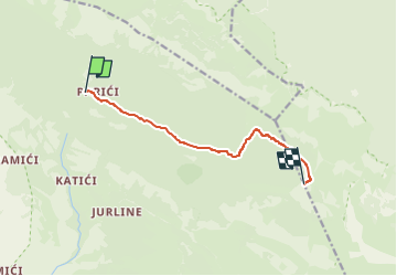
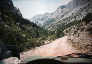
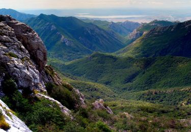
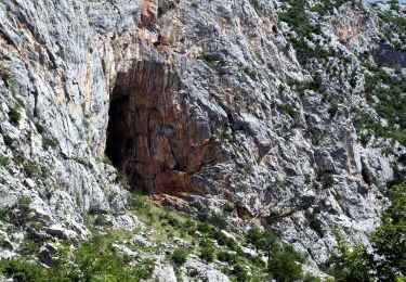
Trail On foot of 7.7 km to be discovered at Unknown, Zadar County. This trail is proposed by SityTrail - itinéraires balisés pédestres.
Description
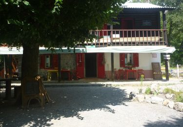
Planinarski dom u Velikoj Paklenici-južnom stranom potoka Velika Paklenica-(x) Samarđinovac-(x)spoj s putom iz Velikih Močila-(x) Martinovo mirilo-(x) Sklonište Ivine vodice-(x) Sklonište Vlaški grad-Vlaški grad vrh
Positioning
Comments
Trails nearby
![Trail On foot - Bukova staza - Photo](https://media.geolcdn.com/t/375/260/0293162d-3a5f-4b15-b737-440dbc2c1183.jpeg&format=jpg&maxdim=2)
![On foot On foot](https://static1.geolcdn.com/sitytour/trail-icons/100.png)
![Trail On foot - Dom u Velikoj Paklenici - Krajni brig - Photo](https://media.geolcdn.com/t/375/260/9b12ad8e-78b9-402d-9026-622d8b2790f2.jpeg&format=jpg&maxdim=2)
![On foot On foot](https://static1.geolcdn.com/sitytour/trail-icons/100.png)
On foot
![](/images/other/stat-length.png)
![](https://static1.geolcdn.com/siteimages/upload/files/16400158638029165_repeat_loop_refresh_sync_direction_icon.png)
![Trail On foot - Golić - Stražbenica - Photo](https://media.geolcdn.com/t/375/260/1fb005e9-31bf-41ad-b0c1-91bb8d8fb8c4.jpeg&format=jpg&maxdim=2)
![On foot On foot](https://static1.geolcdn.com/sitytour/trail-icons/100.png)
![Trail On foot - Velika Paklenica - Veliko Rujno - Photo](https://media.geolcdn.com/t/375/260/de1d9525-12a4-4a1f-b8b9-2408f57069ec.jpeg&format=jpg&maxdim=2)
![On foot On foot](https://static1.geolcdn.com/sitytour/trail-icons/100.png)
On foot
![](/images/other/stat-length.png)
![](https://static1.geolcdn.com/siteimages/upload/files/16400158638029165_repeat_loop_refresh_sync_direction_icon.png)
![Trail On foot - Dom u Velikoj Paklenici - Stražbenica - Photo](https://media.geolcdn.com/t/375/260/74943b82-bfa9-49f1-8ba4-6b0b9dfe9937.jpeg&format=jpg&maxdim=2)
![On foot On foot](https://static1.geolcdn.com/sitytour/trail-icons/100.png)
On foot
![](/images/other/stat-length.png)
![](https://static1.geolcdn.com/siteimages/upload/files/16400158638029165_repeat_loop_refresh_sync_direction_icon.png)
![Trail On foot - Lipa staza - Photo](https://media.geolcdn.com/t/375/260/cd3917a8-4228-43c8-9d12-c2fc6fd497bd.jpeg&format=jpg&maxdim=2)
![On foot On foot](https://static1.geolcdn.com/sitytour/trail-icons/100.png)
![Trail On foot - Struge - Vaganski vrh - Photo](https://media.geolcdn.com/t/375/260/3896feef-29ff-4652-b14a-a616281106d1.jpeg&format=jpg&maxdim=2)
![On foot On foot](https://static1.geolcdn.com/sitytour/trail-icons/100.png)
On foot
![](/images/other/stat-length.png)
![](https://static1.geolcdn.com/siteimages/upload/files/16400158638029165_repeat_loop_refresh_sync_direction_icon.png)
![Trail On foot - Jukići - Lekine njive - Photo](https://media.geolcdn.com/t/375/260/be0f4560-8517-4ec9-b620-7cf42012e680.jpeg&format=jpg&maxdim=2)
![On foot On foot](https://static1.geolcdn.com/sitytour/trail-icons/100.png)
On foot
![](/images/other/stat-length.png)
![](https://static1.geolcdn.com/siteimages/upload/files/16400158638029165_repeat_loop_refresh_sync_direction_icon.png)
![Trail On foot - Vaganski vrh - Sveto Brdo - Photo](https://media.geolcdn.com/t/375/260/afedae5b-4209-4d66-bdba-6cfba3f997ff.jpeg&format=jpg&maxdim=2)
![On foot On foot](https://static1.geolcdn.com/sitytour/trail-icons/100.png)
On foot
![](/images/other/stat-length.png)
![](https://static1.geolcdn.com/siteimages/upload/files/16400158638029165_repeat_loop_refresh_sync_direction_icon.png)