![](/images/other/stat-length.png)
![Trail On foot Štětí - NS Loupežníka Štětky - Photo](https://media.geolcdn.com/t/1900/400/d50d668e-4b12-43e6-8074-ee6f74d1a7c6.jpeg&format=pjpeg&maxdim=2)
NS Loupežníka Štětky
SityTrail - itinéraires balisés pédestres
Tous les sentiers balisés d’Europe GUIDE+
![Length](/images/other/stat-length.png)
Length
28 km
![Max alt](https://static1.geolcdn.com/siteimages/upload/files/1508320355ic_sort_altitude_max_24dp.png)
Max alt
346 m
![Uphill gradient](https://static1.geolcdn.com/siteimages/upload/files/1508320355ic_sort_den_pos_24dp.png)
Uphill gradient
379 m
![Km-Effort](/images/other/stat-length.png)
Km-Effort
33 km
![Min alt](https://static1.geolcdn.com/siteimages/upload/files/1508320355ic_sort_altitude_min_24dp.png)
Min alt
159 m
![Downhill gradient](https://static1.geolcdn.com/siteimages/upload/files/1508320355ic_sort_den_neg_24dp.png)
Downhill gradient
381 m
![Boucle](https://static1.geolcdn.com/siteimages/upload/files/16400158638029165_repeat_loop_refresh_sync_direction_icon.png)
Boucle
Yes
Signpost
Creation date :
2025-02-07 11:02:10.076
Updated on :
2025-02-07 11:02:10.076
![On foot](https://static1.geolcdn.com/sitytour/trail-icons/100.png)
7h34
Difficulty : Difficult
![Scan this QR Code to open this trail in the SityTrail application](https://capi.geolives.com/qq0zvz2zws4bq2lad0pu/sitytour/trails/4345392/qr.png?size=200)
FREE GPS app for hiking
About
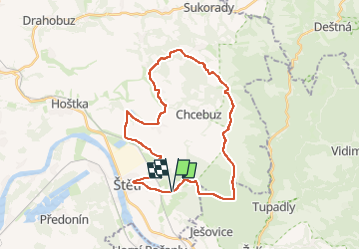
Trail On foot of 28 km to be discovered at Northwest, Ústecký kraj, Štětí. This trail is proposed by SityTrail - itinéraires balisés pédestres.
Description
Trail created by cz:KČT.
Website: http://www.stetsko.cz/cs/tipy-na-vylety/naucne-putovani-loupeznika-stetky.html
Positioning
Country:
Czech Republic
Region :
Northwest
Department/Province :
Ústecký kraj
Municipality :
Štětí
Location:
Unknown
Start:(Dec)
Start:(UTM)
457839 ; 5588828 (33U) N.
Comments
Trails nearby
![Trail On foot Štětí - NS Loupežníka Štětky - Photo](https://media.geolcdn.com/t/375/260/51ee37d2-ab1d-4d8a-8573-145cb4c1f798.jpeg&format=jpg&maxdim=2)
![On foot On foot](https://static1.geolcdn.com/sitytour/trail-icons/100.png)
NS Loupežníka Štětky
On foot
Easy
Štětí,
Northwest,
Ústecký kraj,
Czech Republic
![](/images/other/stat-length.png)
3.8 km | 4.2 km-effort
57min
![](https://static1.geolcdn.com/siteimages/upload/files/16400158638029165_repeat_loop_refresh_sync_direction_icon.png)
No
![Trail On foot Štětí - [M] Štětí - Ledčice - Photo](https://media.geolcdn.com/t/375/260/bec04fab-17ef-4ed8-9aa1-9f79da79c802.jpeg&format=jpg&maxdim=2)
![On foot On foot](https://static1.geolcdn.com/sitytour/trail-icons/100.png)
[M] Štětí - Ledčice
On foot
Difficult
Štětí,
Northwest,
Ústecký kraj,
Czech Republic
![](/images/other/stat-length.png)
28 km | 35 km-effort
8h 2min
![](https://static1.geolcdn.com/siteimages/upload/files/16400158638029165_repeat_loop_refresh_sync_direction_icon.png)
No
![Trail On foot Želízy - [Ž] Želízy - Štětí - Photo](https://media.geolcdn.com/t/375/260/5fe56eac-7584-4af0-9a4b-860224c197e4.jpeg&format=jpg&maxdim=2)
![On foot On foot](https://static1.geolcdn.com/sitytour/trail-icons/100.png)
[Ž] Želízy - Štětí
On foot
Easy
Želízy,
Central Bohemia,
Unknown,
Czech Republic
![](/images/other/stat-length.png)
9.5 km | 11.2 km-effort
2h 33min
![](https://static1.geolcdn.com/siteimages/upload/files/16400158638029165_repeat_loop_refresh_sync_direction_icon.png)
No
![Trail On foot Liběchov - [M] Okruh Václava Levého - Photo](https://media.geolcdn.com/t/375/260/e5904d4a-7cd6-4b86-95b3-486fa6e70af0.jpeg&format=jpg&maxdim=2)
![On foot On foot](https://static1.geolcdn.com/sitytour/trail-icons/100.png)
[M] Okruh Václava Levého
On foot
Easy
Liběchov,
Central Bohemia,
Unknown,
Czech Republic
![](/images/other/stat-length.png)
11.1 km | 14.3 km-effort
3h 14min
![](https://static1.geolcdn.com/siteimages/upload/files/16400158638029165_repeat_loop_refresh_sync_direction_icon.png)
Yes