![](/images/other/stat-length.png)
![Trail On foot Unknown - Osredek - Beder - Photo](https://media.geolcdn.com/t/1900/400/02f74ee7-f7a8-4cd6-a4f4-99b06a677f3c.jpeg&format=pjpeg&maxdim=2)
Osredek - Beder
SityTrail - itinéraires balisés pédestres
Tous les sentiers balisés d’Europe GUIDE+
![Length](/images/other/stat-length.png)
Length
6.4 km
![Max alt](https://static1.geolcdn.com/siteimages/upload/files/1508320355ic_sort_altitude_max_24dp.png)
Max alt
559 m
![Uphill gradient](https://static1.geolcdn.com/siteimages/upload/files/1508320355ic_sort_den_pos_24dp.png)
Uphill gradient
395 m
![Km-Effort](/images/other/stat-length.png)
Km-Effort
10.9 km
![Min alt](https://static1.geolcdn.com/siteimages/upload/files/1508320355ic_sort_altitude_min_24dp.png)
Min alt
246 m
![Downhill gradient](https://static1.geolcdn.com/siteimages/upload/files/1508320355ic_sort_den_neg_24dp.png)
Downhill gradient
140 m
![Boucle](https://static1.geolcdn.com/siteimages/upload/files/16400158638029165_repeat_loop_refresh_sync_direction_icon.png)
Boucle
No
Signpost
Creation date :
2025-02-07 10:54:05.444
Updated on :
2025-02-07 10:54:05.444
![On foot](https://static1.geolcdn.com/sitytour/trail-icons/100.png)
2h28
Difficulty : Easy
![Scan this QR Code to open this trail in the SityTrail application](https://capi.geolives.com/qq0zvz2zws4bq2lad0pu/sitytour/trails/4345373/qr.png?size=200)
FREE GPS app for hiking
About
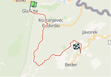
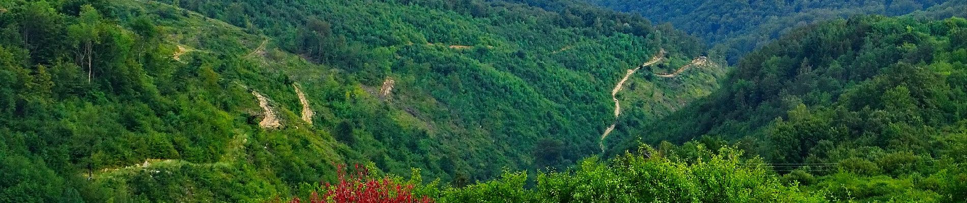
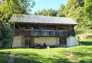
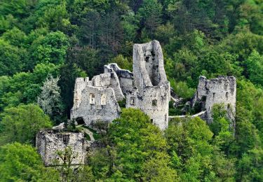
Trail On foot of 6.4 km to be discovered at Unknown, Zagreb County. This trail is proposed by SityTrail - itinéraires balisés pédestres.
Description
Trail created by PK Scout, Samobor.
Osredek - Kostanjevec Podvrški - Vučica - (X) s 62 za Beder i Grdanjce
Positioning
Country:
Croatia
Region :
Unknown
Department/Province :
Zagreb County
Municipality :
Unknown
Location:
Unknown
Start:(Dec)
Start:(UTM)
545523 ; 5075630 (33T) N.
Comments
Trails nearby
![Trail On foot - Grdanjci - Noršić selo - Photo](https://media.geolcdn.com/t/375/260/360e921b-97d3-4b67-9f69-dac3c02b0938.jpeg&format=jpg&maxdim=2)
![On foot On foot](https://static1.geolcdn.com/sitytour/trail-icons/100.png)
Grdanjci - Noršić selo
On foot
Easy
,
Unknown,
Zagreb County,
Croatia
![](/images/other/stat-length.png)
7.1 km | 9.8 km-effort
2h 13min
![](https://static1.geolcdn.com/siteimages/upload/files/16400158638029165_repeat_loop_refresh_sync_direction_icon.png)
No
![Trail On foot - Koretići - Poklek - Photo](https://media.geolcdn.com/t/375/260/d7fc09e4-b763-4816-8be1-38bb077973f8.jpeg&format=jpg&maxdim=2)
![On foot On foot](https://static1.geolcdn.com/sitytour/trail-icons/100.png)
Koretići - Poklek
On foot
Easy
,
Unknown,
Zagreb County,
Croatia
![](/images/other/stat-length.png)
6.9 km | 12.1 km-effort
2h 44min
![](https://static1.geolcdn.com/siteimages/upload/files/16400158638029165_repeat_loop_refresh_sync_direction_icon.png)
No
![Trail On foot - Koretići - Kravljak - Photo](https://media.geolcdn.com/t/375/260/d7fc09e4-b763-4816-8be1-38bb077973f8.jpeg&format=jpg&maxdim=2)
![On foot On foot](https://static1.geolcdn.com/sitytour/trail-icons/100.png)
Koretići - Kravljak
On foot
Easy
,
Unknown,
Zagreb County,
Croatia
![](/images/other/stat-length.png)
3.8 km | 5.1 km-effort
1h 9min
![](https://static1.geolcdn.com/siteimages/upload/files/16400158638029165_repeat_loop_refresh_sync_direction_icon.png)
No
![Trail On foot - Gabrovica - Kravljak - Photo](https://media.geolcdn.com/t/375/260/052fddf2-4498-409b-a8ab-f02cb8a90db8.jpeg&format=jpg&maxdim=2)
![On foot On foot](https://static1.geolcdn.com/sitytour/trail-icons/100.png)
Gabrovica - Kravljak
On foot
Easy
,
Unknown,
Zagreb County,
Croatia
![](/images/other/stat-length.png)
5 km | 8.6 km-effort
1h 57min
![](https://static1.geolcdn.com/siteimages/upload/files/16400158638029165_repeat_loop_refresh_sync_direction_icon.png)
No
![Trail On foot - Kravljak - Stojdraga - Photo](https://media.geolcdn.com/t/375/260/ee1b2247-18e5-488b-8e88-33333aefa699.jpeg&format=jpg&maxdim=2)
![On foot On foot](https://static1.geolcdn.com/sitytour/trail-icons/100.png)
Kravljak - Stojdraga
On foot
Easy
,
Unknown,
Zagreb County,
Croatia
![](/images/other/stat-length.png)
13 km | 18.1 km-effort
4h 6min
![](https://static1.geolcdn.com/siteimages/upload/files/16400158638029165_repeat_loop_refresh_sync_direction_icon.png)
No
![Trail On foot - Noršić Selo - Katin krč - Photo](https://media.geolcdn.com/t/375/260/b167355c-57af-49c1-ae87-931613543d0f.jpeg&format=jpg&maxdim=2)
![On foot On foot](https://static1.geolcdn.com/sitytour/trail-icons/100.png)
Noršić Selo - Katin krč
On foot
Easy
,
Unknown,
Zagreb County,
Croatia
![](/images/other/stat-length.png)
5.9 km | 9.5 km-effort
2h 9min
![](https://static1.geolcdn.com/siteimages/upload/files/16400158638029165_repeat_loop_refresh_sync_direction_icon.png)
No
![Trail On foot - Slani dol - Noršić Selo - Photo](https://media.geolcdn.com/t/375/260/360e921b-97d3-4b67-9f69-dac3c02b0938.jpeg&format=jpg&maxdim=2)
![On foot On foot](https://static1.geolcdn.com/sitytour/trail-icons/100.png)
Slani dol - Noršić Selo
On foot
Easy
,
Unknown,
Zagreb County,
Croatia
![](/images/other/stat-length.png)
6.6 km | 10.4 km-effort
2h 22min
![](https://static1.geolcdn.com/siteimages/upload/files/16400158638029165_repeat_loop_refresh_sync_direction_icon.png)
No
![Trail On foot - Grgosova špilja - Slani dol - Photo](https://media.geolcdn.com/t/375/260/e1d74823-4105-4a56-acd7-4a4d2d506da5.jpeg&format=jpg&maxdim=2)
![On foot On foot](https://static1.geolcdn.com/sitytour/trail-icons/100.png)
Grgosova špilja - Slani dol
On foot
Easy
,
Unknown,
Zagreb County,
Croatia
![](/images/other/stat-length.png)
6.9 km | 9.4 km-effort
2h 7min
![](https://static1.geolcdn.com/siteimages/upload/files/16400158638029165_repeat_loop_refresh_sync_direction_icon.png)
No