![](/images/other/stat-length.png)
![Trail On foot Samobor - Samobor - Veliki dol - Photo](https://media.geolcdn.com/t/1900/400/21b94185-510f-4546-991c-c62af1c7bf3f.jpeg&format=pjpeg&maxdim=2)
Samobor - Veliki dol
SityTrail - itinéraires balisés pédestres
Tous les sentiers balisés d’Europe GUIDE+
![Length](/images/other/stat-length.png)
![Max alt](https://static1.geolcdn.com/siteimages/upload/files/1508320355ic_sort_altitude_max_24dp.png)
![Uphill gradient](https://static1.geolcdn.com/siteimages/upload/files/1508320355ic_sort_den_pos_24dp.png)
![Km-Effort](/images/other/stat-length.png)
![Min alt](https://static1.geolcdn.com/siteimages/upload/files/1508320355ic_sort_altitude_min_24dp.png)
![Downhill gradient](https://static1.geolcdn.com/siteimages/upload/files/1508320355ic_sort_den_neg_24dp.png)
![Boucle](https://static1.geolcdn.com/siteimages/upload/files/16400158638029165_repeat_loop_refresh_sync_direction_icon.png)
![On foot](https://static1.geolcdn.com/sitytour/trail-icons/100.png)
2h35
Difficulty : Easy
![Scan this QR Code to open this trail in the SityTrail application](https://capi.geolives.com/qq0zvz2zws4bq2lad0pu/sitytour/trails/4345370/qr.png?size=200)
FREE GPS app for hiking
About
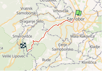
Trail On foot of 6.8 km to be discovered at Unknown, Zagreb County, Samobor. This trail is proposed by SityTrail - itinéraires balisés pédestres.
Description
Trail created by HPD Željezničar, Zagreb.
Samobor (most preko Gradne u blizini Samoborskog muzeja) - Vugrinščak - Taborec - Rudarska draga (a.p.) - Čudomerščak - Palačnik - hrbat Pozorin (X s 22 Veliki Črnec) - Gregurić Breg - X s 23 iz Smerovišća
Positioning
Comments
Trails nearby
![Trail On foot Samobor - Samobor (Hamor) - Slani dol - Photo](https://media.geolcdn.com/t/375/260/287cd65b-9650-4adb-ad52-53091d2e9f31.jpeg&format=jpg&maxdim=2)
![On foot On foot](https://static1.geolcdn.com/sitytour/trail-icons/100.png)
On foot
![](/images/other/stat-length.png)
![](https://static1.geolcdn.com/siteimages/upload/files/16400158638029165_repeat_loop_refresh_sync_direction_icon.png)
![Trail On foot - Rude - Plešivica - Photo](https://media.geolcdn.com/t/375/260/64d55e2e-dd75-4144-9e92-e25a189ac92c.jpeg&format=jpg&maxdim=2)
![On foot On foot](https://static1.geolcdn.com/sitytour/trail-icons/100.png)
![Trail On foot Samobor - Samobor - Grgosova špilja - Photo](https://media.geolcdn.com/t/375/260/8fc87167-64f8-4dce-99f6-168edd44cd77.jpeg&format=jpg&maxdim=2)
![On foot On foot](https://static1.geolcdn.com/sitytour/trail-icons/100.png)
On foot
![](/images/other/stat-length.png)
![](https://static1.geolcdn.com/siteimages/upload/files/16400158638029165_repeat_loop_refresh_sync_direction_icon.png)
![Trail On foot Svetonedeljski Breg - Stepinčev put 5. etapa - Photo](https://media.geolcdn.com/t/375/260/29db60e5-e299-4503-a6f4-cfe86e766c98.jpeg&format=jpg&maxdim=2)
![On foot On foot](https://static1.geolcdn.com/sitytour/trail-icons/100.png)
On foot
![](/images/other/stat-length.png)
![](https://static1.geolcdn.com/siteimages/upload/files/16400158638029165_repeat_loop_refresh_sync_direction_icon.png)