![](/images/other/stat-length.png)
![Trail On foot Unknown - Medven draga - Brisalo - Photo](https://media.geolcdn.com/t/1900/400/38d62b06-f0c7-47dd-bba8-e9faa0c1b63c.jpeg&format=pjpeg&maxdim=2)
Medven draga - Brisalo
SityTrail - itinéraires balisés pédestres
Tous les sentiers balisés d’Europe GUIDE+
![Length](/images/other/stat-length.png)
Length
7 km
![Max alt](https://static1.geolcdn.com/siteimages/upload/files/1508320355ic_sort_altitude_max_24dp.png)
Max alt
300 m
![Uphill gradient](https://static1.geolcdn.com/siteimages/upload/files/1508320355ic_sort_den_pos_24dp.png)
Uphill gradient
220 m
![Km-Effort](/images/other/stat-length.png)
Km-Effort
9.6 km
![Min alt](https://static1.geolcdn.com/siteimages/upload/files/1508320355ic_sort_altitude_min_24dp.png)
Min alt
170 m
![Downhill gradient](https://static1.geolcdn.com/siteimages/upload/files/1508320355ic_sort_den_neg_24dp.png)
Downhill gradient
119 m
![Boucle](https://static1.geolcdn.com/siteimages/upload/files/16400158638029165_repeat_loop_refresh_sync_direction_icon.png)
Boucle
No
Signpost
Creation date :
2025-02-07 10:51:05.342
Updated on :
2025-02-07 10:51:05.342
![On foot](https://static1.geolcdn.com/sitytour/trail-icons/100.png)
2h10
Difficulty : Easy
![Scan this QR Code to open this trail in the SityTrail application](https://capi.geolives.com/qq0zvz2zws4bq2lad0pu/sitytour/trails/4345361/qr.png?size=200)
FREE GPS app for hiking
About
Trail On foot of 7 km to be discovered at Unknown, Zagreb County. This trail is proposed by SityTrail - itinéraires balisés pédestres.
Description
Trail created by HPD Jastrebarsko, Jastrebarsko.
Medven Draga (a.p.) - Ribički dom - (X) za Vranjački slap - (X) za slap Brisalo
Positioning
Country:
Croatia
Region :
Unknown
Department/Province :
Zagreb County
Municipality :
Unknown
Location:
Unknown
Start:(Dec)
Start:(UTM)
539046 ; 5059500 (33T) N.
Comments
Trails nearby
![Trail On foot - Vranjački Slap - Tihočaj - Photo](https://media.geolcdn.com/t/375/260/38d62b06-f0c7-47dd-bba8-e9faa0c1b63c.jpeg&format=jpg&maxdim=2)
![On foot On foot](https://static1.geolcdn.com/sitytour/trail-icons/100.png)
Vranjački Slap - Tihočaj
On foot
Easy
,
Unknown,
Zagreb County,
Croatia
![](/images/other/stat-length.png)
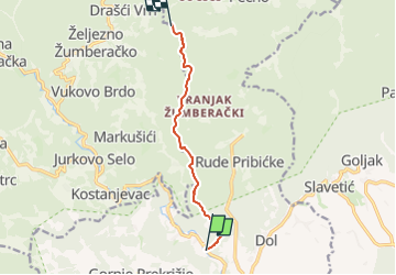
9.8 km | 15.7 km-effort
3h 34min
![](https://static1.geolcdn.com/siteimages/upload/files/16400158638029165_repeat_loop_refresh_sync_direction_icon.png)
No
![Trail On foot - Stepinčev put 1. etapa - Photo](https://media.geolcdn.com/t/375/260/73bf0c80-9176-45c7-96df-71efcc0c2966.jpeg&format=jpg&maxdim=2)
![On foot On foot](https://static1.geolcdn.com/sitytour/trail-icons/100.png)
Stepinčev put 1. etapa
On foot
Easy
,
Unknown,
Zagreb County,
Croatia
![](/images/other/stat-length.png)
5.3 km | 6.5 km-effort
1h 29min
![](https://static1.geolcdn.com/siteimages/upload/files/16400158638029165_repeat_loop_refresh_sync_direction_icon.png)
Yes
![Trail On foot - Stepinčev put 2. etapa - Photo](https://media.geolcdn.com/t/375/260/73bf0c80-9176-45c7-96df-71efcc0c2966.jpeg&format=jpg&maxdim=2)
![On foot On foot](https://static1.geolcdn.com/sitytour/trail-icons/100.png)
Stepinčev put 2. etapa
On foot
Easy
,
Unknown,
Zagreb County,
Croatia
![](/images/other/stat-length.png)
3.5 km | 4.6 km-effort
1h 2min
![](https://static1.geolcdn.com/siteimages/upload/files/16400158638029165_repeat_loop_refresh_sync_direction_icon.png)
No
![Trail On foot - Slavetić - Tihočaj - Photo](https://media.geolcdn.com/t/375/260/ext.jpg?maxdim=2&url=https%3A%2F%2Fstatic1.geolcdn.com%2Fsiteimages%2Fupload%2Ffiles%2F1545311037marcheuse_200dpi.jpg)
![On foot On foot](https://static1.geolcdn.com/sitytour/trail-icons/100.png)
Slavetić - Tihočaj
On foot
Easy
,
Unknown,
Zagreb County,
Croatia
![](/images/other/stat-length.png)
6.3 km | 11.2 km-effort
2h 32min
![](https://static1.geolcdn.com/siteimages/upload/files/16400158638029165_repeat_loop_refresh_sync_direction_icon.png)
No