


4.4 km | 6.7 km-effort
![Trail On foot Načeradec - [Ž] Načeradec - Dolní Královice - Photo](https://media.geolcdn.com/t/1900/400/abc587a4-d8ff-40b4-bfd6-900f9bef250f.jpeg&format=pjpeg&maxdim=2)

Tous les sentiers balisés d’Europe GUIDE+


FREE GPS app for hiking
 SityTrail
IGN / Geographical institutes
SityTrail World
The world is yours!
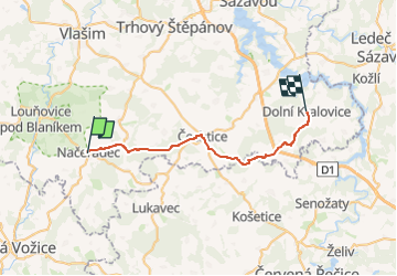
Trail On foot of 26 km to be discovered at Central Bohemia, Unknown, Načeradec. This trail is proposed by SityTrail - itinéraires balisés pédestres.
Trail created by cz:KČT.
![Trail On foot Načeradec - [Ž] Načeradec - Dolní Královice - Photo 1](https://media.geolcdn.com/t/2048/auto/43e8b500-e262-446e-820a-1bf96b9b1ad6.jpeg&format=jpg&maxdim=0 "Trail On foot Načeradec - [Ž] Načeradec - Dolní Královice - Photo 1")
![Trail On foot Načeradec - [Ž] Načeradec - Dolní Královice - Photo 2](https://media.geolcdn.com/t/2048/auto/abd97f33-8f00-442b-b15c-ddc3f41ad3cd.jpeg&format=jpg&maxdim=0 "Trail On foot Načeradec - [Ž] Načeradec - Dolní Královice - Photo 2")
![Trail On foot Načeradec - [Ž] Načeradec - Dolní Královice - Photo 3](https://media.geolcdn.com/t/2048/auto/e076ac53-6ef0-4b69-ab35-68849166882f.jpeg&format=jpg&maxdim=0 "Trail On foot Načeradec - [Ž] Načeradec - Dolní Královice - Photo 3")
![Trail On foot Načeradec - [Ž] Načeradec - Dolní Královice - Photo 4](https://media.geolcdn.com/t/2048/auto/a3a86fb8-d5e5-4a45-a64f-14b733fecf4c.jpeg&format=jpg&maxdim=0 "Trail On foot Načeradec - [Ž] Načeradec - Dolní Královice - Photo 4")
![Trail On foot Načeradec - [Ž] Načeradec - Dolní Královice - Photo 5](https://media.geolcdn.com/t/2048/auto/fce4816d-671e-4c93-89db-5f747e795d23.jpeg&format=jpg&maxdim=0 "Trail On foot Načeradec - [Ž] Načeradec - Dolní Královice - Photo 5")
![Trail On foot Načeradec - [Ž] Načeradec - Dolní Královice - Photo 6](https://media.geolcdn.com/t/2048/auto/c5538320-29ff-4318-9a75-7b83418e0189.jpeg&format=jpg&maxdim=0 "Trail On foot Načeradec - [Ž] Načeradec - Dolní Královice - Photo 6")
![Trail On foot Načeradec - [Ž] Načeradec - Dolní Královice - Photo 7](https://media.geolcdn.com/t/2048/auto/5c70b41e-9cd5-45eb-8bc0-581019aa336f.jpeg&format=jpg&maxdim=0 "Trail On foot Načeradec - [Ž] Načeradec - Dolní Královice - Photo 7")
![Trail On foot Načeradec - [Ž] Načeradec - Dolní Královice - Photo 8](https://media.geolcdn.com/t/2048/auto/e79171cc-b916-471d-8965-994819043898.jpeg&format=jpg&maxdim=0 "Trail On foot Načeradec - [Ž] Načeradec - Dolní Královice - Photo 8")
![Trail On foot Načeradec - [Ž] Načeradec - Dolní Královice - Photo 9](https://media.geolcdn.com/t/2048/auto/5a442963-c297-4989-9c3e-fc221de82eb0.jpeg&format=jpg&maxdim=0 "Trail On foot Načeradec - [Ž] Načeradec - Dolní Královice - Photo 9")
![Trail On foot Načeradec - [Ž] Načeradec - Dolní Královice - Photo 10](https://media.geolcdn.com/t/2048/auto/abc587a4-d8ff-40b4-bfd6-900f9bef250f.jpeg&format=jpg&maxdim=0 "Trail On foot Načeradec - [Ž] Načeradec - Dolní Královice - Photo 10")
On foot