


3.8 km | 4.8 km-effort
![Trail On foot Knyk - [Z] Havlíčkův Brod - Rozňák - Photo](https://media.geolcdn.com/t/1900/400/535a2752-5f55-42c5-bb45-cbdaadba2019.jpeg&format=pjpeg&maxdim=2)

Tous les sentiers balisés d’Europe GUIDE+


FREE GPS app for hiking
 SityTrail
IGN / Geographical institutes
SityTrail World
The world is yours!
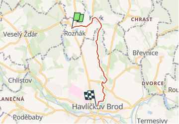
Trail On foot of 6.9 km to be discovered at Southeast, Kraj Vysočina, Knyk. This trail is proposed by SityTrail - itinéraires balisés pédestres.
Trail created by cz:KČT.
![Trail On foot Knyk - [Z] Havlíčkův Brod - Rozňák - Photo 1](https://media.geolcdn.com/t/2048/auto/ed0a4d70-5ef3-46bf-aa83-2ba7d6d263e5.jpeg&format=jpg&maxdim=0 "Trail On foot Knyk - [Z] Havlíčkův Brod - Rozňák - Photo 1")
![Trail On foot Knyk - [Z] Havlíčkův Brod - Rozňák - Photo 2](https://media.geolcdn.com/t/2048/auto/ec45cb9a-695f-41a2-b452-64abf449b33d.jpeg&format=jpg&maxdim=0 "Trail On foot Knyk - [Z] Havlíčkův Brod - Rozňák - Photo 2")
![Trail On foot Knyk - [Z] Havlíčkův Brod - Rozňák - Photo 3](https://media.geolcdn.com/t/2048/auto/2ddad7f5-39fe-414e-ae30-f6ed3b1f7cdd.jpeg&format=jpg&maxdim=0 "Trail On foot Knyk - [Z] Havlíčkův Brod - Rozňák - Photo 3")
![Trail On foot Knyk - [Z] Havlíčkův Brod - Rozňák - Photo 4](https://media.geolcdn.com/t/2048/auto/2b70ba3c-46b6-4b1e-82db-fe2df1518be2.jpeg&format=jpg&maxdim=0 "Trail On foot Knyk - [Z] Havlíčkův Brod - Rozňák - Photo 4")
![Trail On foot Knyk - [Z] Havlíčkův Brod - Rozňák - Photo 5](https://media.geolcdn.com/t/2048/auto/d00ff39c-6c93-42ae-8452-187077ed2ad5.jpeg&format=jpg&maxdim=0 "Trail On foot Knyk - [Z] Havlíčkův Brod - Rozňák - Photo 5")
![Trail On foot Knyk - [Z] Havlíčkův Brod - Rozňák - Photo 6](https://media.geolcdn.com/t/2048/auto/84a33067-bbd1-4a91-9b66-e46be256ec94.jpeg&format=jpg&maxdim=0 "Trail On foot Knyk - [Z] Havlíčkův Brod - Rozňák - Photo 6")
![Trail On foot Knyk - [Z] Havlíčkův Brod - Rozňák - Photo 7](https://media.geolcdn.com/t/2048/auto/043e4a46-24fd-4de1-93a9-4ea38638bc30.jpeg&format=jpg&maxdim=0 "Trail On foot Knyk - [Z] Havlíčkův Brod - Rozňák - Photo 7")
![Trail On foot Knyk - [Z] Havlíčkův Brod - Rozňák - Photo 8](https://media.geolcdn.com/t/2048/auto/c8afd330-1dcb-42fa-a19d-f4c01e9adba3.jpeg&format=jpg&maxdim=0 "Trail On foot Knyk - [Z] Havlíčkův Brod - Rozňák - Photo 8")
![Trail On foot Knyk - [Z] Havlíčkův Brod - Rozňák - Photo 9](https://media.geolcdn.com/t/2048/auto/535a2752-5f55-42c5-bb45-cbdaadba2019.jpeg&format=jpg&maxdim=0 "Trail On foot Knyk - [Z] Havlíčkův Brod - Rozňák - Photo 9")
![Trail On foot Knyk - [Z] Havlíčkův Brod - Rozňák - Photo 10](https://media.geolcdn.com/t/2048/auto/5d94a94f-4ed8-4c6a-bcbd-0f7574e70ed1.jpeg&format=jpg&maxdim=0 "Trail On foot Knyk - [Z] Havlíčkův Brod - Rozňák - Photo 10")
On foot
On foot