


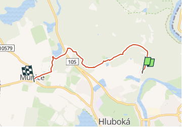

4.2 km | 5.8 km-effort
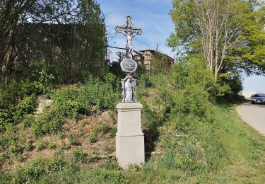
![Trail On foot Hluboká nad Vltavou - [Ž] Munice - Pod Janečkem - Photo](https://media.geolcdn.com/t/1900/400/419a5c8c-be46-4e45-ba12-1064ebe743d7.jpeg&format=pjpeg&maxdim=2)

Tous les sentiers balisés d’Europe GUIDE+


FREE GPS app for hiking
 SityTrail
IGN / Geographical institutes
SityTrail World
The world is yours!
Trail On foot of 4.6 km to be discovered at Southwest, Jihočeský kraj, Hluboká nad Vltavou. This trail is proposed by SityTrail - itinéraires balisés pédestres.
Trail created by cz:KČT.
![Trail On foot Hluboká nad Vltavou - [Ž] Munice - Pod Janečkem - Photo 1](https://media.geolcdn.com/t/2048/auto/b4b1ecc8-077d-47d6-982c-31e5c37d4b2e.jpeg&format=jpg&maxdim=0 "Trail On foot Hluboká nad Vltavou - [Ž] Munice - Pod Janečkem - Photo 1")
![Trail On foot Hluboká nad Vltavou - [Ž] Munice - Pod Janečkem - Photo 2](https://media.geolcdn.com/t/2048/auto/58a2f0cb-3998-408a-a731-d92dfe8bc14e.jpeg&format=jpg&maxdim=0 "Trail On foot Hluboká nad Vltavou - [Ž] Munice - Pod Janečkem - Photo 2")
![Trail On foot Hluboká nad Vltavou - [Ž] Munice - Pod Janečkem - Photo 3](https://media.geolcdn.com/t/2048/auto/f1fdd442-7522-4b7e-a537-19af160599d6.jpeg&format=jpg&maxdim=0 "Trail On foot Hluboká nad Vltavou - [Ž] Munice - Pod Janečkem - Photo 3")
![Trail On foot Hluboká nad Vltavou - [Ž] Munice - Pod Janečkem - Photo 4](https://media.geolcdn.com/t/2048/auto/7eb999eb-a0d9-4bd2-b6b0-b82ec71407fb.jpeg&format=jpg&maxdim=0 "Trail On foot Hluboká nad Vltavou - [Ž] Munice - Pod Janečkem - Photo 4")
![Trail On foot Hluboká nad Vltavou - [Ž] Munice - Pod Janečkem - Photo 5](https://media.geolcdn.com/t/2048/auto/2a041d74-d2e9-4e3a-92d1-de39e16171ad.jpeg&format=jpg&maxdim=0 "Trail On foot Hluboká nad Vltavou - [Ž] Munice - Pod Janečkem - Photo 5")
![Trail On foot Hluboká nad Vltavou - [Ž] Munice - Pod Janečkem - Photo 6](https://media.geolcdn.com/t/2048/auto/7697b706-e066-4fe7-a5a7-20bda8b611de.jpeg&format=jpg&maxdim=0 "Trail On foot Hluboká nad Vltavou - [Ž] Munice - Pod Janečkem - Photo 6")
![Trail On foot Hluboká nad Vltavou - [Ž] Munice - Pod Janečkem - Photo 7](https://media.geolcdn.com/t/2048/auto/80743145-a3d4-45cf-b61e-671a5a65aeed.jpeg&format=jpg&maxdim=0 "Trail On foot Hluboká nad Vltavou - [Ž] Munice - Pod Janečkem - Photo 7")
![Trail On foot Hluboká nad Vltavou - [Ž] Munice - Pod Janečkem - Photo 8](https://media.geolcdn.com/t/2048/auto/63f2702c-edfa-430e-86e8-202cde42b0ca.jpeg&format=jpg&maxdim=0 "Trail On foot Hluboká nad Vltavou - [Ž] Munice - Pod Janečkem - Photo 8")
![Trail On foot Hluboká nad Vltavou - [Ž] Munice - Pod Janečkem - Photo 9](https://media.geolcdn.com/t/2048/auto/511b1c12-5430-4490-8cde-1df4834b185f.jpeg&format=jpg&maxdim=0 "Trail On foot Hluboká nad Vltavou - [Ž] Munice - Pod Janečkem - Photo 9")
![Trail On foot Hluboká nad Vltavou - [Ž] Munice - Pod Janečkem - Photo 10](https://media.geolcdn.com/t/2048/auto/419a5c8c-be46-4e45-ba12-1064ebe743d7.jpeg&format=jpg&maxdim=0 "Trail On foot Hluboká nad Vltavou - [Ž] Munice - Pod Janečkem - Photo 10")
On foot