


9.7 km | 11.6 km-effort
![Trail On foot Lubná - [Ž] Rakovník - Senecká hora - Photo](https://media.geolcdn.com/t/1900/400/dff3753f-98a3-47a5-8521-cd2a1a4dd151.jpeg&format=pjpeg&maxdim=2)

Tous les sentiers balisés d’Europe GUIDE+


FREE GPS app for hiking
 SityTrail
IGN / Geographical institutes
SityTrail World
The world is yours!
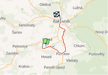
Trail On foot of 10.9 km to be discovered at Central Bohemia, Unknown, Lubná. This trail is proposed by SityTrail - itinéraires balisés pédestres.
Trail created by cz:KČT.
![Trail On foot Lubná - [Ž] Rakovník - Senecká hora - Photo 1](https://media.geolcdn.com/t/2048/auto/11420199-8285-4c5d-b526-429643ee8b90.jpeg&format=jpg&maxdim=0 "Trail On foot Lubná - [Ž] Rakovník - Senecká hora - Photo 1")
![Trail On foot Lubná - [Ž] Rakovník - Senecká hora - Photo 2](https://media.geolcdn.com/t/2048/auto/f4fd293e-c89c-4119-89e8-6f44a189357e.jpeg&format=jpg&maxdim=0 "Trail On foot Lubná - [Ž] Rakovník - Senecká hora - Photo 2")
![Trail On foot Lubná - [Ž] Rakovník - Senecká hora - Photo 3](https://media.geolcdn.com/t/2048/auto/76b2c4e8-c963-4efd-a28e-242f1d8aab39.jpeg&format=jpg&maxdim=0 "Trail On foot Lubná - [Ž] Rakovník - Senecká hora - Photo 3")
![Trail On foot Lubná - [Ž] Rakovník - Senecká hora - Photo 4](https://media.geolcdn.com/t/2048/auto/6015ed8e-6a2a-4c58-9ccd-65b9c9e6870e.jpeg&format=jpg&maxdim=0 "Trail On foot Lubná - [Ž] Rakovník - Senecká hora - Photo 4")
![Trail On foot Lubná - [Ž] Rakovník - Senecká hora - Photo 5](https://media.geolcdn.com/t/2048/auto/617f7347-093f-46a7-a520-0a64db9debdd.jpeg&format=jpg&maxdim=0 "Trail On foot Lubná - [Ž] Rakovník - Senecká hora - Photo 5")
![Trail On foot Lubná - [Ž] Rakovník - Senecká hora - Photo 6](https://media.geolcdn.com/t/2048/auto/014f533c-a24d-4d19-bb7c-a2c518ddf91b.jpeg&format=jpg&maxdim=0 "Trail On foot Lubná - [Ž] Rakovník - Senecká hora - Photo 6")
![Trail On foot Lubná - [Ž] Rakovník - Senecká hora - Photo 7](https://media.geolcdn.com/t/2048/auto/e37ecc1d-fc0c-4f87-8612-473c596bac1b.jpeg&format=jpg&maxdim=0 "Trail On foot Lubná - [Ž] Rakovník - Senecká hora - Photo 7")
![Trail On foot Lubná - [Ž] Rakovník - Senecká hora - Photo 8](https://media.geolcdn.com/t/2048/auto/84d6feb3-6b14-47c3-80ca-fe28b4004e54.jpeg&format=jpg&maxdim=0 "Trail On foot Lubná - [Ž] Rakovník - Senecká hora - Photo 8")
![Trail On foot Lubná - [Ž] Rakovník - Senecká hora - Photo 9](https://media.geolcdn.com/t/2048/auto/dff3753f-98a3-47a5-8521-cd2a1a4dd151.jpeg&format=jpg&maxdim=0 "Trail On foot Lubná - [Ž] Rakovník - Senecká hora - Photo 9")
![Trail On foot Lubná - [Ž] Rakovník - Senecká hora - Photo 10](https://media.geolcdn.com/t/2048/auto/ec2fef5f-3330-44fb-a956-787898effb74.jpeg&format=jpg&maxdim=0 "Trail On foot Lubná - [Ž] Rakovník - Senecká hora - Photo 10")
![Trail On foot Rakovník - [Ž] Měststský okruh IVV - Photo](https://media.geolcdn.com/t/375/260/eff4da05-f915-4356-8fee-71a257493d98.jpeg&format=jpg&maxdim=2)
On foot