


伊予ヶ岳-富山

SityTrail - itinéraires balisés pédestres
Tous les sentiers balisés d’Europe GUIDE+
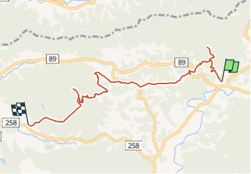

Length
8.6 km

Max alt
348 m

Uphill gradient
611 m
Km-Effort
16.8 km

Min alt
39 m

Downhill gradient
634 m
Boucle
No

Signpost
Creation date :
2025-02-07 10:04:49.537
Updated on :
2025-02-07 10:04:49.537
3h49
Difficulty : Easy

FREE GPS app for hiking
 SityTrail
IGN / Geographical institutes
SityTrail World
The world is yours!
About
Trail On foot of 8.6 km to be discovered at Chiba Prefecture. This trail is proposed by SityTrail - itinéraires balisés pédestres.
Photos


Positioning
Country:
Japan
Region :
Chiba Prefecture
Department/Province :
Unknown
Municipality :
Unknown
Location:
Unknown
Start:(Dec)
Start:(UTM)
401342 ; 3884731 (54S) N.
Comments
Trails nearby