![](/images/other/stat-length.png)
![Trail On foot Pasohlávky - naučná stezka Věstonická nádrž - Photo](https://media.geolcdn.com/t/1900/400/3d0b1149-4243-407e-a2fd-50ba23414fb3.jpeg&format=pjpeg&maxdim=2)
naučná stezka Věstonická nádrž
SityTrail - itinéraires balisés pédestres
Tous les sentiers balisés d’Europe GUIDE+
![Length](/images/other/stat-length.png)
Length
13.3 km
![Max alt](https://static1.geolcdn.com/siteimages/upload/files/1508320355ic_sort_altitude_max_24dp.png)
Max alt
185 m
![Uphill gradient](https://static1.geolcdn.com/siteimages/upload/files/1508320355ic_sort_den_pos_24dp.png)
Uphill gradient
84 m
![Km-Effort](/images/other/stat-length.png)
Km-Effort
14.5 km
![Min alt](https://static1.geolcdn.com/siteimages/upload/files/1508320355ic_sort_altitude_min_24dp.png)
Min alt
162 m
![Downhill gradient](https://static1.geolcdn.com/siteimages/upload/files/1508320355ic_sort_den_neg_24dp.png)
Downhill gradient
93 m
![Boucle](https://static1.geolcdn.com/siteimages/upload/files/16400158638029165_repeat_loop_refresh_sync_direction_icon.png)
Boucle
No
Signpost
Creation date :
2025-02-07 09:56:52.139
Updated on :
2025-02-07 09:56:52.139
![On foot](https://static1.geolcdn.com/sitytour/trail-icons/100.png)
3h17
Difficulty : Easy
![Scan this QR Code to open this trail in the SityTrail application](https://capi.geolives.com/qq0zvz2zws4bq2lad0pu/sitytour/trails/4345153/qr.png?size=200)
FREE GPS app for hiking
About
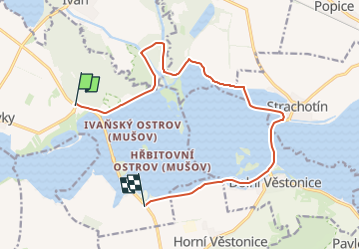
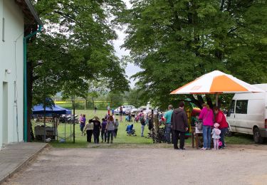
Trail On foot of 13.3 km to be discovered at Southeast, Jihomoravský kraj, Pasohlávky. This trail is proposed by SityTrail - itinéraires balisés pédestres.
Description
Trail created by cz:KČT.
Symbol: green:white:green_bar
Positioning
Country:
Czech Republic
Region :
Southeast
Department/Province :
Jihomoravský kraj
Municipality :
Pasohlávky
Location:
Unknown
Start:(Dec)
Start:(UTM)
615495 ; 5418168 (33U) N.
Comments
Trails nearby
![Trail On foot Miroslav - Okruh Miroslavské kopce - Photo](https://media.geolcdn.com/t/375/260/3221cc3c-a9f3-4f28-880f-beaad17e940f.jpeg&format=jpg&maxdim=2)
![On foot On foot](https://static1.geolcdn.com/sitytour/trail-icons/100.png)
Okruh Miroslavské kopce
On foot
Easy
Miroslav,
Southeast,
Jihomoravský kraj,
Czech Republic
![](/images/other/stat-length.png)
4.4 km | 5.7 km-effort
1h 17min
![](https://static1.geolcdn.com/siteimages/upload/files/16400158638029165_repeat_loop_refresh_sync_direction_icon.png)
Yes
![Trail On foot Nosislav - [M] Nosislav - Výhon - Photo](https://media.geolcdn.com/t/375/260/f5229b3c-0400-439f-9460-019b796ae514.jpeg&format=jpg&maxdim=2)
![On foot On foot](https://static1.geolcdn.com/sitytour/trail-icons/100.png)
[M] Nosislav - Výhon
On foot
Easy
Nosislav,
Southeast,
Jihomoravský kraj,
Czech Republic
![](/images/other/stat-length.png)
5.3 km | 7.5 km-effort
1h 41min
![](https://static1.geolcdn.com/siteimages/upload/files/16400158638029165_repeat_loop_refresh_sync_direction_icon.png)
No
![Trail On foot Sedlec - NS Lednické rybníky - Photo](https://media.geolcdn.com/t/375/260/1c01ab89-d5cd-4c84-82f8-92c11e7665a3.jpeg&format=jpg&maxdim=2)
![On foot On foot](https://static1.geolcdn.com/sitytour/trail-icons/100.png)
NS Lednické rybníky
On foot
Easy
Sedlec,
Southeast,
Jihomoravský kraj,
Czech Republic
![](/images/other/stat-length.png)
4.3 km | 4.7 km-effort
1h 4min
![](https://static1.geolcdn.com/siteimages/upload/files/16400158638029165_repeat_loop_refresh_sync_direction_icon.png)
No
![Trail On foot Velké Pavlovice - NS Zastavení v kraji vína a meruněk - Photo](https://media.geolcdn.com/t/375/260/708e3aa3-f60e-428a-a214-42171592e431.jpeg&format=jpg&maxdim=2)
![On foot On foot](https://static1.geolcdn.com/sitytour/trail-icons/100.png)
NS Zastavení v kraji vína a meruněk
On foot
Easy
Velké Pavlovice,
Southeast,
Jihomoravský kraj,
Czech Republic
![](/images/other/stat-length.png)
6.1 km | 7.3 km-effort
1h 40min
![](https://static1.geolcdn.com/siteimages/upload/files/16400158638029165_repeat_loop_refresh_sync_direction_icon.png)
No
![Trail On foot Hustopeče - Mandloňová NS - Photo](https://media.geolcdn.com/t/375/260/fe1036b5-094b-4768-a841-ed5954c5125b.jpeg&format=jpg&maxdim=2)
![On foot On foot](https://static1.geolcdn.com/sitytour/trail-icons/100.png)
Mandloňová NS
On foot
Easy
Hustopeče,
Southeast,
Jihomoravský kraj,
Czech Republic
![](/images/other/stat-length.png)
10.1 km | 13.4 km-effort
3h 3min
![](https://static1.geolcdn.com/siteimages/upload/files/16400158638029165_repeat_loop_refresh_sync_direction_icon.png)
No
![Trail On foot Pavlov - NS Archeostezka Dolní Věstonice - Pavlov - Photo](https://media.geolcdn.com/t/375/260/5e0199f9-0103-4637-bdf9-f9a02f137294.jpeg&format=jpg&maxdim=2)
![On foot On foot](https://static1.geolcdn.com/sitytour/trail-icons/100.png)
NS Archeostezka Dolní Věstonice - Pavlov
On foot
Easy
Pavlov,
Southeast,
Jihomoravský kraj,
Czech Republic
![](/images/other/stat-length.png)
3.3 km | 3.7 km-effort
51min
![](https://static1.geolcdn.com/siteimages/upload/files/16400158638029165_repeat_loop_refresh_sync_direction_icon.png)
No
![Trail On foot Valtice - NS Valtice - Photo](https://media.geolcdn.com/t/375/260/6bf591b9-aa86-4b29-9da0-90a1a18550b9.jpeg&format=jpg&maxdim=2)
![On foot On foot](https://static1.geolcdn.com/sitytour/trail-icons/100.png)
NS Valtice
On foot
Easy
Valtice,
Southeast,
Jihomoravský kraj,
Czech Republic
![](/images/other/stat-length.png)
4.4 km | 6 km-effort
1h 22min
![](https://static1.geolcdn.com/siteimages/upload/files/16400158638029165_repeat_loop_refresh_sync_direction_icon.png)
No
![Trail On foot Lesonice - Lesonická školní naučná stezka - Photo](https://media.geolcdn.com/t/375/260/b285cb7a-55e5-4a04-996b-db6be9f92a12.jpeg&format=jpg&maxdim=2)
![On foot On foot](https://static1.geolcdn.com/sitytour/trail-icons/100.png)
Lesonická školní naučná stezka
On foot
Easy
Lesonice,
Southeast,
Jihomoravský kraj,
Czech Republic
![](/images/other/stat-length.png)
3.7 km | 4.8 km-effort
1h 5min
![](https://static1.geolcdn.com/siteimages/upload/files/16400158638029165_repeat_loop_refresh_sync_direction_icon.png)
Yes
![Trail On foot Lednice - NS Lužní les - Photo](https://media.geolcdn.com/t/375/260/8eacb7c7-ec2e-4fb4-adee-ae0382044392.jpeg&format=jpg&maxdim=2)
![On foot On foot](https://static1.geolcdn.com/sitytour/trail-icons/100.png)
NS Lužní les
On foot
Easy
Lednice,
Southeast,
Jihomoravský kraj,
Czech Republic
![](/images/other/stat-length.png)
5.9 km | 6.7 km-effort
1h 31min
![](https://static1.geolcdn.com/siteimages/upload/files/16400158638029165_repeat_loop_refresh_sync_direction_icon.png)
No