


4.1 km | 6.1 km-effort
![Trail On foot Bad Gottleuba-Berggießhübel - [Z] okruh Oelsen - Špičák - Oelsen - Photo](https://media.geolcdn.com/t/1900/400/84446251-a0ec-4b89-b1b1-9407074742c9.jpeg&format=pjpeg&maxdim=2)

Tous les sentiers balisés d’Europe GUIDE+


FREE GPS app for hiking
 SityTrail
IGN / Geographical institutes
SityTrail World
The world is yours!
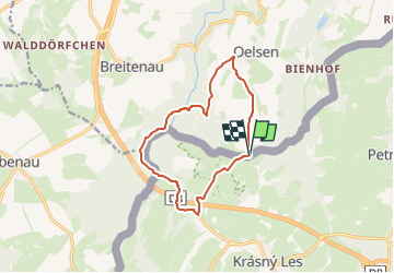
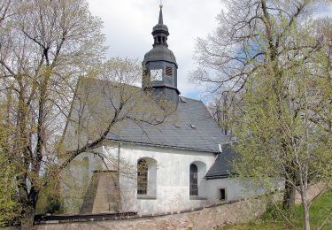
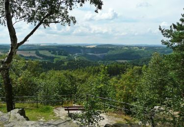
Trail On foot of 10.5 km to be discovered at Saxony, Sächsische Schweiz-Osterzgebirge, Bad Gottleuba-Berggießhübel. This trail is proposed by SityTrail - itinéraires balisés pédestres.
Trail created by cz:KČT.
![Trail On foot Bad Gottleuba-Berggießhübel - [Z] okruh Oelsen - Špičák - Oelsen - Photo 1](https://media.geolcdn.com/t/2048/auto/5a0a3f23-d33b-4de8-bb8c-52fe7bc9395c.jpeg&format=jpg&maxdim=0 "Trail On foot Bad Gottleuba-Berggießhübel - [Z] okruh Oelsen - Špičák - Oelsen - Photo 1")
![Trail On foot Bad Gottleuba-Berggießhübel - [Z] okruh Oelsen - Špičák - Oelsen - Photo 2](https://media.geolcdn.com/t/2048/auto/ec9ac9db-0848-4c97-8b80-3c1a63cd2320.jpeg&format=jpg&maxdim=0 "Trail On foot Bad Gottleuba-Berggießhübel - [Z] okruh Oelsen - Špičák - Oelsen - Photo 2")
![Trail On foot Bad Gottleuba-Berggießhübel - [Z] okruh Oelsen - Špičák - Oelsen - Photo 3](https://media.geolcdn.com/t/2048/auto/885bd364-6133-4cde-85ad-450f7b493957.jpeg&format=jpg&maxdim=0 "Trail On foot Bad Gottleuba-Berggießhübel - [Z] okruh Oelsen - Špičák - Oelsen - Photo 3")
![Trail On foot Bad Gottleuba-Berggießhübel - [Z] okruh Oelsen - Špičák - Oelsen - Photo 4](https://media.geolcdn.com/t/2048/auto/9853be24-a7b0-4484-92db-579bb486763d.jpeg&format=jpg&maxdim=0 "Trail On foot Bad Gottleuba-Berggießhübel - [Z] okruh Oelsen - Špičák - Oelsen - Photo 4")
![Trail On foot Bad Gottleuba-Berggießhübel - [Z] okruh Oelsen - Špičák - Oelsen - Photo 5](https://media.geolcdn.com/t/2048/auto/90e8389f-5f8f-4ebe-80a0-8380bcbcc0a7.jpeg&format=jpg&maxdim=0 "Trail On foot Bad Gottleuba-Berggießhübel - [Z] okruh Oelsen - Špičák - Oelsen - Photo 5")
![Trail On foot Bad Gottleuba-Berggießhübel - [Z] okruh Oelsen - Špičák - Oelsen - Photo 6](https://media.geolcdn.com/t/2048/auto/1fab6d48-9393-4014-96dc-d8913899af09.jpeg&format=jpg&maxdim=0 "Trail On foot Bad Gottleuba-Berggießhübel - [Z] okruh Oelsen - Špičák - Oelsen - Photo 6")
![Trail On foot Bad Gottleuba-Berggießhübel - [Z] okruh Oelsen - Špičák - Oelsen - Photo 7](https://media.geolcdn.com/t/2048/auto/03e2aa83-463c-4b83-9dad-aa0f26b87962.jpeg&format=jpg&maxdim=0 "Trail On foot Bad Gottleuba-Berggießhübel - [Z] okruh Oelsen - Špičák - Oelsen - Photo 7")
![Trail On foot Bad Gottleuba-Berggießhübel - [Z] okruh Oelsen - Špičák - Oelsen - Photo 8](https://media.geolcdn.com/t/2048/auto/b3e4daa9-29c3-4429-b889-848703df87eb.jpeg&format=jpg&maxdim=0 "Trail On foot Bad Gottleuba-Berggießhübel - [Z] okruh Oelsen - Špičák - Oelsen - Photo 8")
![Trail On foot Bad Gottleuba-Berggießhübel - [Z] okruh Oelsen - Špičák - Oelsen - Photo 9](https://media.geolcdn.com/t/2048/auto/7322bfd7-53db-4f7b-890c-5553912f18ad.jpeg&format=jpg&maxdim=0 "Trail On foot Bad Gottleuba-Berggießhübel - [Z] okruh Oelsen - Špičák - Oelsen - Photo 9")
![Trail On foot Bad Gottleuba-Berggießhübel - [Z] okruh Oelsen - Špičák - Oelsen - Photo 10](https://media.geolcdn.com/t/2048/auto/84446251-a0ec-4b89-b1b1-9407074742c9.jpeg&format=jpg&maxdim=0 "Trail On foot Bad Gottleuba-Berggießhübel - [Z] okruh Oelsen - Špičák - Oelsen - Photo 10")
On foot
On foot