![](/images/other/stat-length.png)
![Trail On foot Týniště nad Orlicí - Poorlická NS - Photo](https://media.geolcdn.com/t/1900/400/e040fbfa-7619-48b5-83bf-c6ad79a1d10b.jpeg&format=pjpeg&maxdim=2)
Poorlická NS
SityTrail - itinéraires balisés pédestres
Tous les sentiers balisés d’Europe GUIDE+
![Length](/images/other/stat-length.png)
Length
11.7 km
![Max alt](https://static1.geolcdn.com/siteimages/upload/files/1508320355ic_sort_altitude_max_24dp.png)
Max alt
291 m
![Uphill gradient](https://static1.geolcdn.com/siteimages/upload/files/1508320355ic_sort_den_pos_24dp.png)
Uphill gradient
107 m
![Km-Effort](/images/other/stat-length.png)
Km-Effort
13.1 km
![Min alt](https://static1.geolcdn.com/siteimages/upload/files/1508320355ic_sort_altitude_min_24dp.png)
Min alt
237 m
![Downhill gradient](https://static1.geolcdn.com/siteimages/upload/files/1508320355ic_sort_den_neg_24dp.png)
Downhill gradient
107 m
![Boucle](https://static1.geolcdn.com/siteimages/upload/files/16400158638029165_repeat_loop_refresh_sync_direction_icon.png)
Boucle
Yes
Signpost
Creation date :
2025-02-07 09:35:19.456
Updated on :
2025-02-07 09:35:19.456
![On foot](https://static1.geolcdn.com/sitytour/trail-icons/100.png)
2h58
Difficulty : Easy
![Scan this QR Code to open this trail in the SityTrail application](https://capi.geolives.com/qq0zvz2zws4bq2lad0pu/sitytour/trails/4345112/qr.png?size=200)
FREE GPS app for hiking
About
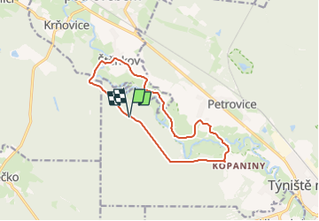
Trail On foot of 11.7 km to be discovered at Northeast, Královéhradecký kraj, Týniště nad Orlicí. This trail is proposed by SityTrail - itinéraires balisés pédestres.
Description
Pěší turistika: Štěpánovsko - Suté Břehy - Štěpánovsko (15,3 km)
Website: https://www.hkregion.cz/dr-cs/100319-poorlicka-naucna-stezka.html
Positioning
Country:
Czech Republic
Region :
Northeast
Department/Province :
Královéhradecký kraj
Municipality :
Týniště nad Orlicí
Location:
Unknown
Start:(Dec)
Start:(UTM)
571675 ; 5557841 (33U) N.
Comments
Trails nearby
![Trail On foot Býšť - [Z] Blešno - Bělečko - Photo](https://media.geolcdn.com/t/375/260/ext.jpg?maxdim=2&url=https%3A%2F%2Fstatic1.geolcdn.com%2Fsiteimages%2Fupload%2Ffiles%2F1545311037marcheuse_200dpi.jpg)
![On foot On foot](https://static1.geolcdn.com/sitytour/trail-icons/100.png)
[Z] Blešno - Bělečko
On foot
Easy
Býšť,
Northeast,
Pardubický kraj,
Czech Republic
![](/images/other/stat-length.png)
8.8 km | 9.8 km-effort
2h 14min
![](https://static1.geolcdn.com/siteimages/upload/files/16400158638029165_repeat_loop_refresh_sync_direction_icon.png)
No