![](/images/other/stat-length.png)
![Trail On foot Máslojedy - Naučná stezka les Svíb - Photo](https://media.geolcdn.com/t/1900/400/bd9d536e-bef5-4974-9128-c0a2c9cde1ea.jpeg&format=pjpeg&maxdim=2)
Naučná stezka les Svíb
SityTrail - itinéraires balisés pédestres
Tous les sentiers balisés d’Europe GUIDE+
![Length](/images/other/stat-length.png)
Length
3.5 km
![Max alt](https://static1.geolcdn.com/siteimages/upload/files/1508320355ic_sort_altitude_max_24dp.png)
Max alt
342 m
![Uphill gradient](https://static1.geolcdn.com/siteimages/upload/files/1508320355ic_sort_den_pos_24dp.png)
Uphill gradient
50 m
![Km-Effort](/images/other/stat-length.png)
Km-Effort
4.3 km
![Min alt](https://static1.geolcdn.com/siteimages/upload/files/1508320355ic_sort_altitude_min_24dp.png)
Min alt
278 m
![Downhill gradient](https://static1.geolcdn.com/siteimages/upload/files/1508320355ic_sort_den_neg_24dp.png)
Downhill gradient
70 m
![Boucle](https://static1.geolcdn.com/siteimages/upload/files/16400158638029165_repeat_loop_refresh_sync_direction_icon.png)
Boucle
No
Signpost
Creation date :
2025-02-07 09:19:23.134
Updated on :
2025-02-07 09:19:23.134
![On foot](https://static1.geolcdn.com/sitytour/trail-icons/100.png)
58m
Difficulty : Easy
![Scan this QR Code to open this trail in the SityTrail application](https://capi.geolives.com/qq0zvz2zws4bq2lad0pu/sitytour/trails/4345071/qr.png?size=200)
FREE GPS app for hiking
About
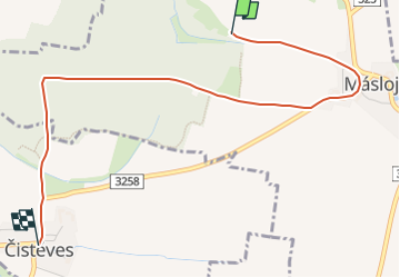
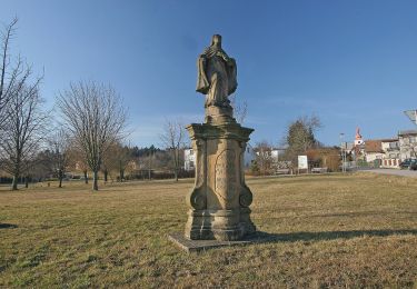
Trail On foot of 3.5 km to be discovered at Northeast, Královéhradecký kraj, Máslojedy. This trail is proposed by SityTrail - itinéraires balisés pédestres.
Description
Trail created by Areál bojiště bitvy 1866 u Hradce Králové.
Positioning
Country:
Czech Republic
Region :
Northeast
Department/Province :
Královéhradecký kraj
Municipality :
Máslojedy
Location:
Unknown
Start:(Dec)
Start:(UTM)
553181 ; 5572201 (33U) N.
Comments
Trails nearby
![Trail On foot Chvalkovice - [Ž] Dolní Vlčkovice - U Střeziměřic - Photo](https://media.geolcdn.com/t/375/260/e2dbb83a-d120-4cf8-9e9d-3f10ec2cbc30.jpeg&format=jpg&maxdim=2)
![On foot On foot](https://static1.geolcdn.com/sitytour/trail-icons/100.png)
[Ž] Dolní Vlčkovice - U Střeziměřic
On foot
Easy
Chvalkovice,
Northeast,
Královéhradecký kraj,
Czech Republic
![](/images/other/stat-length.png)
4 km | 4.3 km-effort
59min
![](https://static1.geolcdn.com/siteimages/upload/files/16400158638029165_repeat_loop_refresh_sync_direction_icon.png)
No
![Trail On foot Týniště nad Orlicí - Poorlická NS - Photo](https://media.geolcdn.com/t/375/260/e040fbfa-7619-48b5-83bf-c6ad79a1d10b.jpeg&format=jpg&maxdim=2)
![On foot On foot](https://static1.geolcdn.com/sitytour/trail-icons/100.png)
Poorlická NS
On foot
Easy
Týniště nad Orlicí,
Northeast,
Královéhradecký kraj,
Czech Republic
![](/images/other/stat-length.png)
11.7 km | 13.1 km-effort
2h 58min
![](https://static1.geolcdn.com/siteimages/upload/files/16400158638029165_repeat_loop_refresh_sync_direction_icon.png)
Yes
![Trail On foot Vysoká nad Labem - NS Koliba - Photo](https://media.geolcdn.com/t/375/260/82fea0da-f465-4ff8-8315-666d12e384fb.jpeg&format=jpg&maxdim=2)
![On foot On foot](https://static1.geolcdn.com/sitytour/trail-icons/100.png)
NS Koliba
On foot
Easy
Vysoká nad Labem,
Northeast,
Královéhradecký kraj,
Czech Republic
![](/images/other/stat-length.png)
7 km | 8.2 km-effort
1h 51min
![](https://static1.geolcdn.com/siteimages/upload/files/16400158638029165_repeat_loop_refresh_sync_direction_icon.png)
No
![Trail On foot Holovousy - Holovousova stezka - Photo](https://media.geolcdn.com/t/375/260/80f2e6e4-7453-4b90-bba7-2cda1b517b26.jpeg&format=jpg&maxdim=2)
![On foot On foot](https://static1.geolcdn.com/sitytour/trail-icons/100.png)
Holovousova stezka
On foot
Easy
Holovousy,
Northeast,
Královéhradecký kraj,
Czech Republic
![](/images/other/stat-length.png)
3.9 km | 4.7 km-effort
1h 4min
![](https://static1.geolcdn.com/siteimages/upload/files/16400158638029165_repeat_loop_refresh_sync_direction_icon.png)
No
![Trail On foot Pecka - CZ-Horní Nová Ves - Arnoštov - Photo](https://media.geolcdn.com/t/375/260/990d8854-4ca8-4d4e-bee6-3d5d8dee4044.jpeg&format=jpg&maxdim=2)
![On foot On foot](https://static1.geolcdn.com/sitytour/trail-icons/100.png)
CZ-Horní Nová Ves - Arnoštov
On foot
Easy
Pecka,
Northeast,
Královéhradecký kraj,
Czech Republic
![](/images/other/stat-length.png)
3 km | 4.2 km-effort
57min
![](https://static1.geolcdn.com/siteimages/upload/files/16400158638029165_repeat_loop_refresh_sync_direction_icon.png)
No
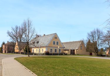
![Trail On foot Lázně Bělohrad - [Z] Horní Javoří - Horní Nová Ves (most) - Photo](https://media.geolcdn.com/t/375/260/86f9bbc9-6897-40b5-b2bb-5f3779a960ee.jpeg&format=jpg&maxdim=2)
![On foot On foot](https://static1.geolcdn.com/sitytour/trail-icons/100.png)
[Z] Horní Javoří - Horní Nová Ves (most)
On foot
Easy
Lázně Bělohrad,
Northeast,
Královéhradecký kraj,
Czech Republic
![](/images/other/stat-length.png)
3.9 km | 6.5 km-effort
1h 29min
![](https://static1.geolcdn.com/siteimages/upload/files/16400158638029165_repeat_loop_refresh_sync_direction_icon.png)
No
![Trail On foot Hořičky - Hořičky - Severní okruh - Photo](https://media.geolcdn.com/t/375/260/366b4ca6-f87c-4396-aca3-407199bc78bd.jpeg&format=jpg&maxdim=2)
![On foot On foot](https://static1.geolcdn.com/sitytour/trail-icons/100.png)
Hořičky - Severní okruh
On foot
Easy
Hořičky,
Northeast,
Královéhradecký kraj,
Czech Republic
![](/images/other/stat-length.png)
3.4 km | 4.2 km-effort
56min
![](https://static1.geolcdn.com/siteimages/upload/files/16400158638029165_repeat_loop_refresh_sync_direction_icon.png)
No
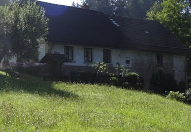
![Trail On foot Litíč - [Z] Hřibojedy - Nouzov - Photo](https://media.geolcdn.com/t/375/260/8e4360c0-0f4f-4484-9216-784360d47d83.jpeg&format=jpg&maxdim=2)
![On foot On foot](https://static1.geolcdn.com/sitytour/trail-icons/100.png)
[Z] Hřibojedy - Nouzov
On foot
Easy
Litíč,
Northeast,
Královéhradecký kraj,
Czech Republic
![](/images/other/stat-length.png)
3.9 km | 5 km-effort
1h 7min
![](https://static1.geolcdn.com/siteimages/upload/files/16400158638029165_repeat_loop_refresh_sync_direction_icon.png)
No
![Trail On foot Brzice - CZ-4223 - Photo](https://media.geolcdn.com/t/375/260/366b4ca6-f87c-4396-aca3-407199bc78bd.jpeg&format=jpg&maxdim=2)
![On foot On foot](https://static1.geolcdn.com/sitytour/trail-icons/100.png)
CZ-4223
On foot
Easy
Brzice,
Northeast,
Královéhradecký kraj,
Czech Republic
![](/images/other/stat-length.png)
4.5 km | 5.9 km-effort
1h 20min
![](https://static1.geolcdn.com/siteimages/upload/files/16400158638029165_repeat_loop_refresh_sync_direction_icon.png)
No