


6.7 km | 9.5 km-effort
![Trail On foot Čachrov - [Z] Javorná - Oldřichovice - Photo](https://media.geolcdn.com/t/1900/400/50fbea2c-5f7c-4f17-b530-7be3f5b63bfd.jpeg&format=pjpeg&maxdim=2)

Tous les sentiers balisés d’Europe GUIDE+


FREE GPS app for hiking
 SityTrail
IGN / Geographical institutes
SityTrail World
The world is yours!
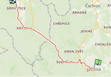
Trail On foot of 9.9 km to be discovered at Southwest, Plzeňský kraj, Čachrov. This trail is proposed by SityTrail - itinéraires balisés pédestres.
Trail created by cz:KČT.
![Trail On foot Čachrov - [Z] Javorná - Oldřichovice - Photo 1](https://media.geolcdn.com/t/2048/auto/031a1264-5897-4b5a-a47b-155247d64605.jpeg&format=jpg&maxdim=0 "Trail On foot Čachrov - [Z] Javorná - Oldřichovice - Photo 1")
![Trail On foot Čachrov - [Z] Javorná - Oldřichovice - Photo 2](https://media.geolcdn.com/t/2048/auto/4123e71c-8ec8-426a-bc28-4531ea21e767.jpeg&format=jpg&maxdim=0 "Trail On foot Čachrov - [Z] Javorná - Oldřichovice - Photo 2")
![Trail On foot Čachrov - [Z] Javorná - Oldřichovice - Photo 3](https://media.geolcdn.com/t/2048/auto/7924a3ab-c46e-4f7a-9b1c-ed27d704c8d8.jpeg&format=jpg&maxdim=0 "Trail On foot Čachrov - [Z] Javorná - Oldřichovice - Photo 3")
![Trail On foot Čachrov - [Z] Javorná - Oldřichovice - Photo 4](https://media.geolcdn.com/t/2048/auto/839c883d-d7e4-4df0-9650-3894d7b40876.jpeg&format=jpg&maxdim=0 "Trail On foot Čachrov - [Z] Javorná - Oldřichovice - Photo 4")
![Trail On foot Čachrov - [Z] Javorná - Oldřichovice - Photo 5](https://media.geolcdn.com/t/2048/auto/f50dd3e2-37e8-4a58-8623-f61baca4ddb1.jpeg&format=jpg&maxdim=0 "Trail On foot Čachrov - [Z] Javorná - Oldřichovice - Photo 5")
![Trail On foot Čachrov - [Z] Javorná - Oldřichovice - Photo 6](https://media.geolcdn.com/t/2048/auto/914096cc-b1e8-4c58-9548-c8108ad6e8b1.jpeg&format=jpg&maxdim=0 "Trail On foot Čachrov - [Z] Javorná - Oldřichovice - Photo 6")
![Trail On foot Čachrov - [Z] Javorná - Oldřichovice - Photo 7](https://media.geolcdn.com/t/2048/auto/84faa1b9-215b-4227-85cf-1c33d9d0e5d8.jpeg&format=jpg&maxdim=0 "Trail On foot Čachrov - [Z] Javorná - Oldřichovice - Photo 7")
![Trail On foot Čachrov - [Z] Javorná - Oldřichovice - Photo 8](https://media.geolcdn.com/t/2048/auto/dbf8ca57-35b7-49ad-92a9-7cd9af21116e.jpeg&format=jpg&maxdim=0 "Trail On foot Čachrov - [Z] Javorná - Oldřichovice - Photo 8")
![Trail On foot Čachrov - [Z] Javorná - Oldřichovice - Photo 9](https://media.geolcdn.com/t/2048/auto/1865c581-af17-4226-8cb4-9b1467151c1d.jpeg&format=jpg&maxdim=0 "Trail On foot Čachrov - [Z] Javorná - Oldřichovice - Photo 9")
![Trail On foot Čachrov - [Z] Javorná - Oldřichovice - Photo 10](https://media.geolcdn.com/t/2048/auto/50fbea2c-5f7c-4f17-b530-7be3f5b63bfd.jpeg&format=jpg&maxdim=0 "Trail On foot Čachrov - [Z] Javorná - Oldřichovice - Photo 10")
![Trail On foot Čachrov - [M] Pod Malým Špičákem - Habr - Photo](https://media.geolcdn.com/t/375/260/6d63f79d-11cc-4587-9739-9e93615a4eec.jpeg&format=jpg&maxdim=2)
On foot
On foot