


13.9 km | 17.9 km-effort
![Trail On foot Semtěš - [M] Sovoluská Lhota - Semtěš - Photo](https://media.geolcdn.com/t/1900/400/6dcc2a2d-a7c6-4ace-9e33-9a21e2524107.jpeg&format=pjpeg&maxdim=2)

Tous les sentiers balisés d’Europe GUIDE+


FREE GPS app for hiking
 SityTrail
IGN / Geographical institutes
SityTrail World
The world is yours!
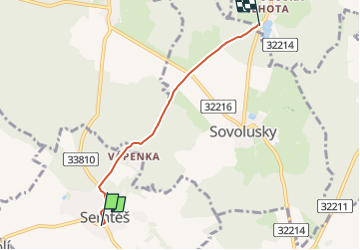
Trail On foot of 3.5 km to be discovered at Central Bohemia, Unknown, Semtěš. This trail is proposed by SityTrail - itinéraires balisés pédestres.
Trail created by cz:KČT.
![Trail On foot Semtěš - [M] Sovoluská Lhota - Semtěš - Photo 1](https://media.geolcdn.com/t/2048/auto/b33dbd4d-63a2-4cf4-a3c1-e620c709bd4d.jpeg&format=jpg&maxdim=0 "Trail On foot Semtěš - [M] Sovoluská Lhota - Semtěš - Photo 1")
![Trail On foot Semtěš - [M] Sovoluská Lhota - Semtěš - Photo 2](https://media.geolcdn.com/t/2048/auto/52b16875-2d7d-44b0-b460-39092fd05bd1.jpeg&format=jpg&maxdim=0 "Trail On foot Semtěš - [M] Sovoluská Lhota - Semtěš - Photo 2")
![Trail On foot Semtěš - [M] Sovoluská Lhota - Semtěš - Photo 3](https://media.geolcdn.com/t/2048/auto/bad118c9-e429-441e-ad4f-61de2b1326f0.jpeg&format=jpg&maxdim=0 "Trail On foot Semtěš - [M] Sovoluská Lhota - Semtěš - Photo 3")
![Trail On foot Semtěš - [M] Sovoluská Lhota - Semtěš - Photo 4](https://media.geolcdn.com/t/2048/auto/d39a05d8-9874-45a6-88cf-ba9663d387f6.jpeg&format=jpg&maxdim=0 "Trail On foot Semtěš - [M] Sovoluská Lhota - Semtěš - Photo 4")
![Trail On foot Semtěš - [M] Sovoluská Lhota - Semtěš - Photo 5](https://media.geolcdn.com/t/2048/auto/dcbb9dfc-9855-4dc7-a204-11a04117121e.jpeg&format=jpg&maxdim=0 "Trail On foot Semtěš - [M] Sovoluská Lhota - Semtěš - Photo 5")
![Trail On foot Semtěš - [M] Sovoluská Lhota - Semtěš - Photo 6](https://media.geolcdn.com/t/2048/auto/deaf74d3-c86b-4653-b366-7f98c5cd1aad.jpeg&format=jpg&maxdim=0 "Trail On foot Semtěš - [M] Sovoluská Lhota - Semtěš - Photo 6")
![Trail On foot Semtěš - [M] Sovoluská Lhota - Semtěš - Photo 7](https://media.geolcdn.com/t/2048/auto/eeedece9-8fa8-459c-ab82-e0e582c3b1d9.jpeg&format=jpg&maxdim=0 "Trail On foot Semtěš - [M] Sovoluská Lhota - Semtěš - Photo 7")
![Trail On foot Semtěš - [M] Sovoluská Lhota - Semtěš - Photo 8](https://media.geolcdn.com/t/2048/auto/f1d3e639-0e5a-4112-9b8e-ece02ea9d5ad.jpeg&format=jpg&maxdim=0 "Trail On foot Semtěš - [M] Sovoluská Lhota - Semtěš - Photo 8")
![Trail On foot Semtěš - [M] Sovoluská Lhota - Semtěš - Photo 9](https://media.geolcdn.com/t/2048/auto/4b4cb51a-3f87-4840-8d60-7e3ab3cd869f.jpeg&format=jpg&maxdim=0 "Trail On foot Semtěš - [M] Sovoluská Lhota - Semtěš - Photo 9")
![Trail On foot Semtěš - [M] Sovoluská Lhota - Semtěš - Photo 10](https://media.geolcdn.com/t/2048/auto/6dcc2a2d-a7c6-4ace-9e33-9a21e2524107.jpeg&format=jpg&maxdim=0 "Trail On foot Semtěš - [M] Sovoluská Lhota - Semtěš - Photo 10")
![Trail On foot Semtěš - [Ž] Konopáč - Semtěš - Photo](https://media.geolcdn.com/t/375/260/4b4cb51a-3f87-4840-8d60-7e3ab3cd869f.jpeg&format=jpg&maxdim=2)
On foot
![Trail On foot Zdechovice - [Ž] Morašice - Svojšice - Photo](https://media.geolcdn.com/t/375/260/f143d729-598a-40d2-b273-3cfaab803058.jpeg&format=jpg&maxdim=2)
On foot