


9.1 km | 12.4 km-effort
![Trail On foot Rozvadov - [M] Okružní naučná stezka Kolowratova - Photo](https://media.geolcdn.com/t/1900/400/48bd39eb-9e5f-4fa1-b21c-b0525a6f7f06.jpeg&format=pjpeg&maxdim=2)

Tous les sentiers balisés d’Europe GUIDE+


FREE GPS app for hiking
 SityTrail
IGN / Geographical institutes
SityTrail World
The world is yours!
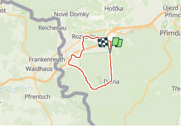
Trail On foot of 17 km to be discovered at Southwest, Plzeňský kraj, Rozvadov. This trail is proposed by SityTrail - itinéraires balisés pédestres.
Trail created by cz:KČT.
![Trail On foot Rozvadov - [M] Okružní naučná stezka Kolowratova - Photo 1](https://media.geolcdn.com/t/2048/auto/217224c3-226a-4524-9b07-25744bd8397d.jpeg&format=jpg&maxdim=0 "Trail On foot Rozvadov - [M] Okružní naučná stezka Kolowratova - Photo 1")
![Trail On foot Rozvadov - [M] Okružní naučná stezka Kolowratova - Photo 2](https://media.geolcdn.com/t/2048/auto/f7c7ce57-cb20-4b4a-9b8e-dd4594ba4640.jpeg&format=jpg&maxdim=0 "Trail On foot Rozvadov - [M] Okružní naučná stezka Kolowratova - Photo 2")
![Trail On foot Rozvadov - [M] Okružní naučná stezka Kolowratova - Photo 3](https://media.geolcdn.com/t/2048/auto/b84a7531-776c-4c3f-ae7f-4e1bb9eab7b8.jpeg&format=jpg&maxdim=0 "Trail On foot Rozvadov - [M] Okružní naučná stezka Kolowratova - Photo 3")
![Trail On foot Rozvadov - [M] Okružní naučná stezka Kolowratova - Photo 4](https://media.geolcdn.com/t/2048/auto/84666b7c-376a-41c0-90f6-bf0b03785590.jpeg&format=jpg&maxdim=0 "Trail On foot Rozvadov - [M] Okružní naučná stezka Kolowratova - Photo 4")
![Trail On foot Rozvadov - [M] Okružní naučná stezka Kolowratova - Photo 5](https://media.geolcdn.com/t/2048/auto/52c3de70-3325-4216-b332-ec560b361cea.jpeg&format=jpg&maxdim=0 "Trail On foot Rozvadov - [M] Okružní naučná stezka Kolowratova - Photo 5")
![Trail On foot Rozvadov - [M] Okružní naučná stezka Kolowratova - Photo 6](https://media.geolcdn.com/t/2048/auto/02455cf5-c01b-49fb-92c2-95c9513902aa.jpeg&format=jpg&maxdim=0 "Trail On foot Rozvadov - [M] Okružní naučná stezka Kolowratova - Photo 6")
![Trail On foot Rozvadov - [M] Okružní naučná stezka Kolowratova - Photo 7](https://media.geolcdn.com/t/2048/auto/d537246a-a0b9-4571-a544-6956362dbcf6.jpeg&format=jpg&maxdim=0 "Trail On foot Rozvadov - [M] Okružní naučná stezka Kolowratova - Photo 7")
![Trail On foot Rozvadov - [M] Okružní naučná stezka Kolowratova - Photo 8](https://media.geolcdn.com/t/2048/auto/7bc53ac4-b7c0-486c-9ce8-4ce8a4f7698a.jpeg&format=jpg&maxdim=0 "Trail On foot Rozvadov - [M] Okružní naučná stezka Kolowratova - Photo 8")
![Trail On foot Rozvadov - [M] Okružní naučná stezka Kolowratova - Photo 9](https://media.geolcdn.com/t/2048/auto/24d1543f-dd3f-4d39-bce7-19877b652f5b.jpeg&format=jpg&maxdim=0 "Trail On foot Rozvadov - [M] Okružní naučná stezka Kolowratova - Photo 9")
![Trail On foot Rozvadov - [M] Okružní naučná stezka Kolowratova - Photo 10](https://media.geolcdn.com/t/2048/auto/48bd39eb-9e5f-4fa1-b21c-b0525a6f7f06.jpeg&format=jpg&maxdim=0 "Trail On foot Rozvadov - [M] Okružní naučná stezka Kolowratova - Photo 10")
![Trail On foot Rozvadov - [Ž] Rybničná -;Pod ovčím kopcem - Photo](https://media.geolcdn.com/t/375/260/cbd477a6-9e51-410c-896f-089efa643184.jpeg&format=jpg&maxdim=2)
On foot