![](/images/other/stat-length.png)
![Trail On foot Unknown - Šoićeva kuća - Japetić - Photo](https://media.geolcdn.com/t/1900/400/b167355c-57af-49c1-ae87-931613543d0f.jpeg&format=pjpeg&maxdim=2)
Šoićeva kuća - Japetić
SityTrail - itinéraires balisés pédestres
Tous les sentiers balisés d’Europe GUIDE+
![Length](/images/other/stat-length.png)
Length
4.4 km
![Max alt](https://static1.geolcdn.com/siteimages/upload/files/1508320355ic_sort_altitude_max_24dp.png)
Max alt
850 m
![Uphill gradient](https://static1.geolcdn.com/siteimages/upload/files/1508320355ic_sort_den_pos_24dp.png)
Uphill gradient
5 m
![Km-Effort](/images/other/stat-length.png)
Km-Effort
6 km
![Min alt](https://static1.geolcdn.com/siteimages/upload/files/1508320355ic_sort_altitude_min_24dp.png)
Min alt
386 m
![Downhill gradient](https://static1.geolcdn.com/siteimages/upload/files/1508320355ic_sort_den_neg_24dp.png)
Downhill gradient
461 m
![Boucle](https://static1.geolcdn.com/siteimages/upload/files/16400158638029165_repeat_loop_refresh_sync_direction_icon.png)
Boucle
No
Signpost
Creation date :
2025-02-07 08:23:14.852
Updated on :
2025-02-07 08:23:14.852
![On foot](https://static1.geolcdn.com/sitytour/trail-icons/100.png)
1h21
Difficulty : Easy
![Scan this QR Code to open this trail in the SityTrail application](https://capi.geolives.com/qq0zvz2zws4bq2lad0pu/sitytour/trails/4344945/qr.png?size=200)
FREE GPS app for hiking
About
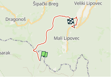
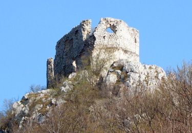
Trail On foot of 4.4 km to be discovered at Unknown, Zagreb County. This trail is proposed by SityTrail - itinéraires balisés pédestres.
Description
Trail created by HPD Japetić, Samobor.
Pl. dom Šoićeva kuća - (X) livada Leskovica - livada Duga draga - (X) livada Katin krč - (X) ispod vrha Japetić
Positioning
Country:
Croatia
Region :
Unknown
Department/Province :
Zagreb County
Municipality :
Unknown
Location:
Unknown
Start:(Dec)
Start:(UTM)
547274 ; 5066198 (33T) N.
Comments
Trails nearby
![Trail On foot - Noršić Selo - Katin krč - Photo](https://media.geolcdn.com/t/375/260/b167355c-57af-49c1-ae87-931613543d0f.jpeg&format=jpg&maxdim=2)
![On foot On foot](https://static1.geolcdn.com/sitytour/trail-icons/100.png)
Noršić Selo - Katin krč
On foot
Easy
,
Unknown,
Zagreb County,
Croatia
![](/images/other/stat-length.png)
5.9 km | 9.5 km-effort
2h 9min
![](https://static1.geolcdn.com/siteimages/upload/files/16400158638029165_repeat_loop_refresh_sync_direction_icon.png)
No
![Trail On foot - Slani dol - Gostinjac Sv. Bernard - Photo](https://media.geolcdn.com/t/375/260/c97b8dc0-0e3a-4e26-bef6-8556ac70acf5.jpeg&format=jpg&maxdim=2)
![On foot On foot](https://static1.geolcdn.com/sitytour/trail-icons/100.png)
Slani dol - Gostinjac Sv. Bernard
On foot
Easy
,
Unknown,
Zagreb County,
Croatia
![](/images/other/stat-length.png)
4.3 km | 6.2 km-effort
1h 24min
![](https://static1.geolcdn.com/siteimages/upload/files/16400158638029165_repeat_loop_refresh_sync_direction_icon.png)
No
![Trail On foot - Grgosova špilja - Slani dol - Photo](https://media.geolcdn.com/t/375/260/e1d74823-4105-4a56-acd7-4a4d2d506da5.jpeg&format=jpg&maxdim=2)
![On foot On foot](https://static1.geolcdn.com/sitytour/trail-icons/100.png)
Grgosova špilja - Slani dol
On foot
Easy
,
Unknown,
Zagreb County,
Croatia
![](/images/other/stat-length.png)
6.9 km | 9.4 km-effort
2h 7min
![](https://static1.geolcdn.com/siteimages/upload/files/16400158638029165_repeat_loop_refresh_sync_direction_icon.png)
No
![Trail On foot - Gornje Rude - Poljanice - Photo](https://media.geolcdn.com/t/375/260/ecb25a92-c337-42e7-952b-54cc173d0117.jpeg&format=jpg&maxdim=2)
![On foot On foot](https://static1.geolcdn.com/sitytour/trail-icons/100.png)
Gornje Rude - Poljanice
On foot
Easy
,
Unknown,
Zagreb County,
Croatia
![](/images/other/stat-length.png)
3.7 km | 4.7 km-effort
1h 4min
![](https://static1.geolcdn.com/siteimages/upload/files/16400158638029165_repeat_loop_refresh_sync_direction_icon.png)
No
![Trail On foot - Draga - Žitnica - Photo](https://media.geolcdn.com/t/375/260/c97b8dc0-0e3a-4e26-bef6-8556ac70acf5.jpeg&format=jpg&maxdim=2)
![On foot On foot](https://static1.geolcdn.com/sitytour/trail-icons/100.png)
![Trail On foot - Dragonoš - Zečak - Photo](https://media.geolcdn.com/t/375/260/c97b8dc0-0e3a-4e26-bef6-8556ac70acf5.jpeg&format=jpg&maxdim=2)
![On foot On foot](https://static1.geolcdn.com/sitytour/trail-icons/100.png)
![Trail On foot - Šoićeva kuća - Sv. Bernard - Photo](https://media.geolcdn.com/t/375/260/c97b8dc0-0e3a-4e26-bef6-8556ac70acf5.jpeg&format=jpg&maxdim=2)
![On foot On foot](https://static1.geolcdn.com/sitytour/trail-icons/100.png)
Šoićeva kuća - Sv. Bernard
On foot
Easy
,
Unknown,
Zagreb County,
Croatia
![](/images/other/stat-length.png)
3.4 km | 5.7 km-effort
1h 17min
![](https://static1.geolcdn.com/siteimages/upload/files/16400158638029165_repeat_loop_refresh_sync_direction_icon.png)
No
![Trail On foot - Stepinčev put 4. etapa - Photo](https://media.geolcdn.com/t/375/260/0eff10e0-d497-4979-a243-eff869dff092.jpeg&format=jpg&maxdim=2)
![On foot On foot](https://static1.geolcdn.com/sitytour/trail-icons/100.png)
Stepinčev put 4. etapa
On foot
Easy
,
Unknown,
Zagreb County,
Croatia
![](/images/other/stat-length.png)
5.9 km | 8.5 km-effort
1h 55min
![](https://static1.geolcdn.com/siteimages/upload/files/16400158638029165_repeat_loop_refresh_sync_direction_icon.png)
No
![Trail On foot - Stepinčev put 3. etapa - Photo](https://media.geolcdn.com/t/375/260/1bbdb2be-a83a-461c-9011-8fe51b583294.jpeg&format=jpg&maxdim=2)
![On foot On foot](https://static1.geolcdn.com/sitytour/trail-icons/100.png)
Stepinčev put 3. etapa
On foot
Easy
,
Unknown,
Zagreb County,
Croatia
![](/images/other/stat-length.png)
6.7 km | 9.9 km-effort
2h 14min
![](https://static1.geolcdn.com/siteimages/upload/files/16400158638029165_repeat_loop_refresh_sync_direction_icon.png)
No