


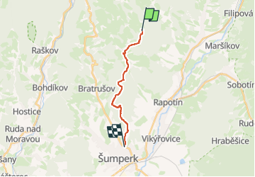

7.4 km | 11 km-effort
![Trail On foot Velké Losiny - [Ž] Potůčník - Šumperk - Photo](https://media.geolcdn.com/t/1900/400/4a090c9a-e757-4d64-809d-5f91060e2f4a.jpeg&format=pjpeg&maxdim=2)

Tous les sentiers balisés d’Europe GUIDE+


FREE GPS app for hiking
 SityTrail
IGN / Geographical institutes
SityTrail World
The world is yours!
Trail On foot of 11.1 km to be discovered at Central Moravia, Olomouc Region, Velké Losiny. This trail is proposed by SityTrail - itinéraires balisés pédestres.
Trail created by cz:KČT.
![Trail On foot Velké Losiny - [Ž] Potůčník - Šumperk - Photo 1](https://media.geolcdn.com/t/2048/auto/1846aef5-4412-4527-8aef-915d208fde03.jpeg&format=jpg&maxdim=0 "Trail On foot Velké Losiny - [Ž] Potůčník - Šumperk - Photo 1")
![Trail On foot Velké Losiny - [Ž] Potůčník - Šumperk - Photo 2](https://media.geolcdn.com/t/2048/auto/e6f0dad6-39a5-48e4-874e-c6b0ccf35876.jpeg&format=jpg&maxdim=0 "Trail On foot Velké Losiny - [Ž] Potůčník - Šumperk - Photo 2")
![Trail On foot Velké Losiny - [Ž] Potůčník - Šumperk - Photo 3](https://media.geolcdn.com/t/2048/auto/6f6e9426-7622-4f23-967b-fc34ef2ba662.jpeg&format=jpg&maxdim=0 "Trail On foot Velké Losiny - [Ž] Potůčník - Šumperk - Photo 3")
![Trail On foot Velké Losiny - [Ž] Potůčník - Šumperk - Photo 4](https://media.geolcdn.com/t/2048/auto/fdbc6489-bbe8-4641-9a2f-94a4719d0b71.jpeg&format=jpg&maxdim=0 "Trail On foot Velké Losiny - [Ž] Potůčník - Šumperk - Photo 4")
![Trail On foot Velké Losiny - [Ž] Potůčník - Šumperk - Photo 5](https://media.geolcdn.com/t/2048/auto/44356b19-2f6e-4bd9-84cf-7d8cb34109aa.jpeg&format=jpg&maxdim=0 "Trail On foot Velké Losiny - [Ž] Potůčník - Šumperk - Photo 5")
![Trail On foot Velké Losiny - [Ž] Potůčník - Šumperk - Photo 6](https://media.geolcdn.com/t/2048/auto/4ec11559-5212-4949-a59c-3d392da97356.jpeg&format=jpg&maxdim=0 "Trail On foot Velké Losiny - [Ž] Potůčník - Šumperk - Photo 6")
![Trail On foot Velké Losiny - [Ž] Potůčník - Šumperk - Photo 7](https://media.geolcdn.com/t/2048/auto/5212e27d-7f66-4404-8141-9356e7fe38c2.jpeg&format=jpg&maxdim=0 "Trail On foot Velké Losiny - [Ž] Potůčník - Šumperk - Photo 7")
![Trail On foot Velké Losiny - [Ž] Potůčník - Šumperk - Photo 8](https://media.geolcdn.com/t/2048/auto/2ef853ac-cea3-498f-a6b5-f190468ba724.jpeg&format=jpg&maxdim=0 "Trail On foot Velké Losiny - [Ž] Potůčník - Šumperk - Photo 8")
![Trail On foot Velké Losiny - [Ž] Potůčník - Šumperk - Photo 9](https://media.geolcdn.com/t/2048/auto/6370bd87-4aac-4352-9778-5057f98a678a.jpeg&format=jpg&maxdim=0 "Trail On foot Velké Losiny - [Ž] Potůčník - Šumperk - Photo 9")
![Trail On foot Velké Losiny - [Ž] Potůčník - Šumperk - Photo 10](https://media.geolcdn.com/t/2048/auto/4a090c9a-e757-4d64-809d-5f91060e2f4a.jpeg&format=jpg&maxdim=0 "Trail On foot Velké Losiny - [Ž] Potůčník - Šumperk - Photo 10")
![Trail On foot Rapotín - [Ž] - Photo](https://media.geolcdn.com/t/375/260/ca426870-e86c-4a96-bde0-2f91190915ef.jpeg&format=jpg&maxdim=2)
On foot
![Trail On foot Rapotín - [M] - Photo](https://media.geolcdn.com/t/375/260/2389b978-f881-4d49-8011-c5e6270880f1.jpeg&format=jpg&maxdim=2)
On foot
On foot