![](/images/other/stat-length.png)
![Trail On foot Ochoz u Brna - naučná stezka Hády a Údolí Říčky - Photo](https://media.geolcdn.com/t/1900/400/ba2d53c2-7acc-4c7d-af68-1d9f242ad3c9.jpeg&format=pjpeg&maxdim=2)
naučná stezka Hády a Údolí Říčky
SityTrail - itinéraires balisés pédestres
Tous les sentiers balisés d’Europe GUIDE+
![Length](/images/other/stat-length.png)
Length
10.2 km
![Max alt](https://static1.geolcdn.com/siteimages/upload/files/1508320355ic_sort_altitude_max_24dp.png)
Max alt
372 m
![Uphill gradient](https://static1.geolcdn.com/siteimages/upload/files/1508320355ic_sort_den_pos_24dp.png)
Uphill gradient
113 m
![Km-Effort](/images/other/stat-length.png)
Km-Effort
12 km
![Min alt](https://static1.geolcdn.com/siteimages/upload/files/1508320355ic_sort_altitude_min_24dp.png)
Min alt
253 m
![Downhill gradient](https://static1.geolcdn.com/siteimages/upload/files/1508320355ic_sort_den_neg_24dp.png)
Downhill gradient
222 m
![Boucle](https://static1.geolcdn.com/siteimages/upload/files/16400158638029165_repeat_loop_refresh_sync_direction_icon.png)
Boucle
No
Signpost
Creation date :
2025-02-07 08:02:02.735
Updated on :
2025-02-07 08:02:02.735
![On foot](https://static1.geolcdn.com/sitytour/trail-icons/100.png)
2h44
Difficulty : Easy
![Scan this QR Code to open this trail in the SityTrail application](https://capi.geolives.com/qq0zvz2zws4bq2lad0pu/sitytour/trails/4344904/qr.png?size=200)
FREE GPS app for hiking
About
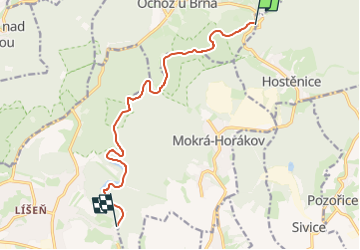
Trail On foot of 10.2 km to be discovered at Southeast, Jihomoravský kraj, Ochoz u Brna. This trail is proposed by SityTrail - itinéraires balisés pédestres.
Description
Trail created by cz:Pozemkový spolek Hády.
Positioning
Country:
Czech Republic
Region :
Southeast
Department/Province :
Jihomoravský kraj
Municipality :
Ochoz u Brna
Location:
Unknown
Start:(Dec)
Start:(UTM)
628382 ; 5456699 (33U) N.
Comments
Trails nearby
![Trail On foot Bukovinka - [Ž] Rakovecké údolí - Malá Říčka - Photo](https://media.geolcdn.com/t/375/260/d06663d7-1067-4c22-b72c-d81a6dabd113.jpeg&format=jpg&maxdim=2)
![On foot On foot](https://static1.geolcdn.com/sitytour/trail-icons/100.png)
[Ž] Rakovecké údolí - Malá Říčka
On foot
Easy
Bukovinka,
Southeast,
Jihomoravský kraj,
Czech Republic
![](/images/other/stat-length.png)
4.4 km | 5.6 km-effort
1h 16min
![](https://static1.geolcdn.com/siteimages/upload/files/16400158638029165_repeat_loop_refresh_sync_direction_icon.png)
No
![Trail On foot Rousínov - CZ-Studánková NS - Photo](https://media.geolcdn.com/t/375/260/26c2a764-b50a-4157-b115-4b0a7dcb62ae.jpeg&format=jpg&maxdim=2)
![On foot On foot](https://static1.geolcdn.com/sitytour/trail-icons/100.png)
CZ-Studánková NS
On foot
Easy
Rousínov,
Southeast,
Jihomoravský kraj,
Czech Republic
![](/images/other/stat-length.png)
8.1 km | 11.3 km-effort
2h 34min
![](https://static1.geolcdn.com/siteimages/upload/files/16400158638029165_repeat_loop_refresh_sync_direction_icon.png)
No
![Trail On foot Pustiměř - Naučná stezka Melice - Photo](https://media.geolcdn.com/t/375/260/4b55e64f-1976-46b7-8693-6e08bb8a9e01.jpeg&format=jpg&maxdim=2)
![On foot On foot](https://static1.geolcdn.com/sitytour/trail-icons/100.png)
Naučná stezka Melice
On foot
Easy
Pustiměř,
Southeast,
Jihomoravský kraj,
Czech Republic
![](/images/other/stat-length.png)
6.7 km | 9 km-effort
2h 2min
![](https://static1.geolcdn.com/siteimages/upload/files/16400158638029165_repeat_loop_refresh_sync_direction_icon.png)
Yes
![Trail On foot Ždánice - Naučná stezka Motýlí ráj - Photo](https://media.geolcdn.com/t/375/260/d13e0f9b-0034-410d-9fa4-ff218220b19f.jpeg&format=jpg&maxdim=2)
![On foot On foot](https://static1.geolcdn.com/sitytour/trail-icons/100.png)
Naučná stezka Motýlí ráj
On foot
Easy
Ždánice,
Southeast,
Jihomoravský kraj,
Czech Republic
![](/images/other/stat-length.png)
5.7 km | 7.9 km-effort
1h 47min
![](https://static1.geolcdn.com/siteimages/upload/files/16400158638029165_repeat_loop_refresh_sync_direction_icon.png)
Yes
![Trail On foot Brno - NS Jelení žlíbek - Photo](https://media.geolcdn.com/t/375/260/6b816b6a-5ba8-4ce8-8ed6-d16b66c07601.jpeg&format=jpg&maxdim=2)
![On foot On foot](https://static1.geolcdn.com/sitytour/trail-icons/100.png)
NS Jelení žlíbek
On foot
Easy
Brno,
Southeast,
Jihomoravský kraj,
Czech Republic
![](/images/other/stat-length.png)
3.3 km | 5.2 km-effort
1h 10min
![](https://static1.geolcdn.com/siteimages/upload/files/16400158638029165_repeat_loop_refresh_sync_direction_icon.png)
No
![Trail On foot Ždánice - [Ž] Černčín - Bučovice - Photo](https://media.geolcdn.com/t/375/260/0e8a5bf5-67a6-4aaf-a695-d3a2c91aad48.jpeg&format=jpg&maxdim=2)
![On foot On foot](https://static1.geolcdn.com/sitytour/trail-icons/100.png)
[Ž] Černčín - Bučovice
On foot
Easy
Ždánice,
Southeast,
Jihomoravský kraj,
Czech Republic
![](/images/other/stat-length.png)
12.1 km | 17.6 km-effort
3h 59min
![](https://static1.geolcdn.com/siteimages/upload/files/16400158638029165_repeat_loop_refresh_sync_direction_icon.png)
No
![Trail On foot Vranov - Krajem říčky Ponávky (pěší) - Photo](https://media.geolcdn.com/t/375/260/d4892074-ca0b-450c-9484-555e1ddcdd27.jpeg&format=jpg&maxdim=2)
![On foot On foot](https://static1.geolcdn.com/sitytour/trail-icons/100.png)
Krajem říčky Ponávky (pěší)
On foot
Easy
Vranov,
Southeast,
Jihomoravský kraj,
Czech Republic
![](/images/other/stat-length.png)
5 km | 7.2 km-effort
1h 37min
![](https://static1.geolcdn.com/siteimages/upload/files/16400158638029165_repeat_loop_refresh_sync_direction_icon.png)
No
![Trail On foot Račice-Pístovice - naučná stezka Rakovecké údolí - Photo](https://media.geolcdn.com/t/375/260/37fc810a-3aca-4e21-9bcd-5baf656f4474.jpeg&format=jpg&maxdim=2)
![On foot On foot](https://static1.geolcdn.com/sitytour/trail-icons/100.png)
naučná stezka Rakovecké údolí
On foot
Easy
Račice-Pístovice,
Southeast,
Jihomoravský kraj,
Czech Republic
![](/images/other/stat-length.png)
6.5 km | 8.4 km-effort
1h 54min
![](https://static1.geolcdn.com/siteimages/upload/files/16400158638029165_repeat_loop_refresh_sync_direction_icon.png)
Yes
![Trail On foot Adamov - NS Josefovské údolí - Photo](https://media.geolcdn.com/t/375/260/9a19130e-fd42-41ac-bfbf-10b2f84988dc.jpeg&format=jpg&maxdim=2)
![On foot On foot](https://static1.geolcdn.com/sitytour/trail-icons/100.png)
NS Josefovské údolí
On foot
Easy
Adamov,
Southeast,
Jihomoravský kraj,
Czech Republic
![](/images/other/stat-length.png)
4.3 km | 5.9 km-effort
1h 19min
![](https://static1.geolcdn.com/siteimages/upload/files/16400158638029165_repeat_loop_refresh_sync_direction_icon.png)
No