


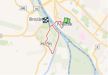

3.5 km | 3.7 km-effort
![Trail On foot Mělník - [Ž] Hořín - okružní trasa - Photo](https://media.geolcdn.com/t/1900/400/32387249-b1a0-4843-aa71-31072a48ece3.jpeg&format=pjpeg&maxdim=2)

Tous les sentiers balisés d’Europe GUIDE+


FREE GPS app for hiking
 SityTrail
IGN / Geographical institutes
SityTrail World
The world is yours!
Trail On foot of 3.8 km to be discovered at Central Bohemia, Unknown, Mělník. This trail is proposed by SityTrail - itinéraires balisés pédestres.
Trail created by cz:KČT.
![Trail On foot Mělník - [Ž] Hořín - okružní trasa - Photo 1](https://media.geolcdn.com/t/2048/auto/7053d4e8-ac19-48b8-bc62-c2f0a73cb616.jpeg&format=jpg&maxdim=0 "Trail On foot Mělník - [Ž] Hořín - okružní trasa - Photo 1")
![Trail On foot Mělník - [Ž] Hořín - okružní trasa - Photo 2](https://media.geolcdn.com/t/2048/auto/716d4339-192b-46d0-a993-169ad2fb4bcc.jpeg&format=jpg&maxdim=0 "Trail On foot Mělník - [Ž] Hořín - okružní trasa - Photo 2")
![Trail On foot Mělník - [Ž] Hořín - okružní trasa - Photo 3](https://media.geolcdn.com/t/2048/auto/f496f18a-c4a0-4128-9ac3-8d8fdba09548.jpeg&format=jpg&maxdim=0 "Trail On foot Mělník - [Ž] Hořín - okružní trasa - Photo 3")
![Trail On foot Mělník - [Ž] Hořín - okružní trasa - Photo 4](https://media.geolcdn.com/t/2048/auto/1582349b-0565-490b-8140-cea8bc10d14c.jpeg&format=jpg&maxdim=0 "Trail On foot Mělník - [Ž] Hořín - okružní trasa - Photo 4")
![Trail On foot Mělník - [Ž] Hořín - okružní trasa - Photo 5](https://media.geolcdn.com/t/2048/auto/55a37c71-d6ae-4b74-8846-bfb53967d072.jpeg&format=jpg&maxdim=0 "Trail On foot Mělník - [Ž] Hořín - okružní trasa - Photo 5")
![Trail On foot Mělník - [Ž] Hořín - okružní trasa - Photo 6](https://media.geolcdn.com/t/2048/auto/73f3342b-c6b1-46f5-8d4c-d0ff348f89a5.jpeg&format=jpg&maxdim=0 "Trail On foot Mělník - [Ž] Hořín - okružní trasa - Photo 6")
![Trail On foot Mělník - [Ž] Hořín - okružní trasa - Photo 7](https://media.geolcdn.com/t/2048/auto/9c10d734-a84a-46dc-9fc4-38628744d4d1.jpeg&format=jpg&maxdim=0 "Trail On foot Mělník - [Ž] Hořín - okružní trasa - Photo 7")
![Trail On foot Mělník - [Ž] Hořín - okružní trasa - Photo 8](https://media.geolcdn.com/t/2048/auto/3d1628dd-ca49-4cc0-8cb6-4ce39894dbaa.jpeg&format=jpg&maxdim=0 "Trail On foot Mělník - [Ž] Hořín - okružní trasa - Photo 8")
![Trail On foot Mělník - [Ž] Hořín - okružní trasa - Photo 9](https://media.geolcdn.com/t/2048/auto/77cc6370-1a2e-49dc-b687-8ddd08954f22.jpeg&format=jpg&maxdim=0 "Trail On foot Mělník - [Ž] Hořín - okružní trasa - Photo 9")
![Trail On foot Mělník - [Ž] Hořín - okružní trasa - Photo 10](https://media.geolcdn.com/t/2048/auto/32387249-b1a0-4843-aa71-31072a48ece3.jpeg&format=jpg&maxdim=0 "Trail On foot Mělník - [Ž] Hořín - okružní trasa - Photo 10")
On foot
![Trail On foot Mělník - [Ž] Mělník - Lhotka - Photo](https://media.geolcdn.com/t/375/260/6568a527-c601-419a-b951-03eae086182d.jpeg&format=jpg&maxdim=2)
On foot
![Trail On foot Mělník - [Z] Mělník - okružní trasa - Photo](https://media.geolcdn.com/t/375/260/e6c96ca9-333e-4cf1-8b0e-018ae508ba3d.jpeg&format=jpg&maxdim=2)
On foot