


9 km | 12.3 km-effort
![Trail On foot Vápenná - [M] Vápenná - Pod Sokolím - Photo](https://media.geolcdn.com/t/1900/400/eb9b14b8-aff6-4c45-9daa-f6f941bf764d.jpeg&format=pjpeg&maxdim=2)

Tous les sentiers balisés d’Europe GUIDE+


FREE GPS app for hiking
 SityTrail
IGN / Geographical institutes
SityTrail World
The world is yours!
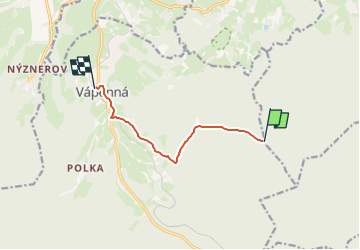
Trail On foot of 6 km to be discovered at Central Moravia, Olomouc Region, Vápenná. This trail is proposed by SityTrail - itinéraires balisés pédestres.
Trail created by cz:KČT.
![Trail On foot Vápenná - [M] Vápenná - Pod Sokolím - Photo 1](https://media.geolcdn.com/t/2048/auto/e48ced5d-dab8-4298-8d8c-92280c6dbbf0.jpeg&format=jpg&maxdim=0 "Trail On foot Vápenná - [M] Vápenná - Pod Sokolím - Photo 1")
![Trail On foot Vápenná - [M] Vápenná - Pod Sokolím - Photo 2](https://media.geolcdn.com/t/2048/auto/65530dba-8648-4e36-853c-18513209095f.jpeg&format=jpg&maxdim=0 "Trail On foot Vápenná - [M] Vápenná - Pod Sokolím - Photo 2")
![Trail On foot Vápenná - [M] Vápenná - Pod Sokolím - Photo 3](https://media.geolcdn.com/t/2048/auto/968d5a90-e23b-44bd-8502-d0565701ad53.jpeg&format=jpg&maxdim=0 "Trail On foot Vápenná - [M] Vápenná - Pod Sokolím - Photo 3")
![Trail On foot Vápenná - [M] Vápenná - Pod Sokolím - Photo 4](https://media.geolcdn.com/t/2048/auto/b835b22b-e300-4aa9-aaac-906af7e23613.jpeg&format=jpg&maxdim=0 "Trail On foot Vápenná - [M] Vápenná - Pod Sokolím - Photo 4")
![Trail On foot Vápenná - [M] Vápenná - Pod Sokolím - Photo 5](https://media.geolcdn.com/t/2048/auto/2c7c4654-121e-48f7-b2c5-41d221d18947.jpeg&format=jpg&maxdim=0 "Trail On foot Vápenná - [M] Vápenná - Pod Sokolím - Photo 5")
![Trail On foot Vápenná - [M] Vápenná - Pod Sokolím - Photo 6](https://media.geolcdn.com/t/2048/auto/518b6d7d-9d51-4560-8a0c-1a7eaea57c55.jpeg&format=jpg&maxdim=0 "Trail On foot Vápenná - [M] Vápenná - Pod Sokolím - Photo 6")
![Trail On foot Vápenná - [M] Vápenná - Pod Sokolím - Photo 7](https://media.geolcdn.com/t/2048/auto/c8109b3c-e876-43f6-96d9-c270799da175.jpeg&format=jpg&maxdim=0 "Trail On foot Vápenná - [M] Vápenná - Pod Sokolím - Photo 7")
![Trail On foot Vápenná - [M] Vápenná - Pod Sokolím - Photo 8](https://media.geolcdn.com/t/2048/auto/01eaba47-6283-4d7e-9499-1b901bfb3e58.jpeg&format=jpg&maxdim=0 "Trail On foot Vápenná - [M] Vápenná - Pod Sokolím - Photo 8")
![Trail On foot Vápenná - [M] Vápenná - Pod Sokolím - Photo 9](https://media.geolcdn.com/t/2048/auto/e4533453-5323-4e5c-8a8f-ec7f31bd40aa.jpeg&format=jpg&maxdim=0 "Trail On foot Vápenná - [M] Vápenná - Pod Sokolím - Photo 9")
![Trail On foot Vápenná - [M] Vápenná - Pod Sokolím - Photo 10](https://media.geolcdn.com/t/2048/auto/eb9b14b8-aff6-4c45-9daa-f6f941bf764d.jpeg&format=jpg&maxdim=0 "Trail On foot Vápenná - [M] Vápenná - Pod Sokolím - Photo 10")

On foot