![](/images/other/stat-length.png)
![Trail On foot Horní Blatná - NS Blatenský příkop - Photo](https://media.geolcdn.com/t/1900/400/a9fe3d15-a59b-43a8-be9b-2f06e4f2ce18.jpeg&format=pjpeg&maxdim=2)
NS Blatenský příkop
SityTrail - itinéraires balisés pédestres
Tous les sentiers balisés d’Europe GUIDE+
![Length](/images/other/stat-length.png)
Length
10.8 km
![Max alt](https://static1.geolcdn.com/siteimages/upload/files/1508320355ic_sort_altitude_max_24dp.png)
Max alt
981 m
![Uphill gradient](https://static1.geolcdn.com/siteimages/upload/files/1508320355ic_sort_den_pos_24dp.png)
Uphill gradient
100 m
![Km-Effort](/images/other/stat-length.png)
Km-Effort
12.1 km
![Min alt](https://static1.geolcdn.com/siteimages/upload/files/1508320355ic_sort_altitude_min_24dp.png)
Min alt
946 m
![Downhill gradient](https://static1.geolcdn.com/siteimages/upload/files/1508320355ic_sort_den_neg_24dp.png)
Downhill gradient
69 m
![Boucle](https://static1.geolcdn.com/siteimages/upload/files/16400158638029165_repeat_loop_refresh_sync_direction_icon.png)
Boucle
No
Signpost
Creation date :
2025-02-07 06:06:01.642
Updated on :
2025-02-07 06:06:01.642
![On foot](https://static1.geolcdn.com/sitytour/trail-icons/100.png)
2h44
Difficulty : Easy
![Scan this QR Code to open this trail in the SityTrail application](https://capi.geolives.com/qq0zvz2zws4bq2lad0pu/sitytour/trails/4344737/qr.png?size=200)
FREE GPS app for hiking
About
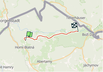
Trail On foot of 10.8 km to be discovered at Northwest, Karlovarský kraj, Horní Blatná. This trail is proposed by SityTrail - itinéraires balisés pédestres.
Description
Trail created by cz:KČT.
Positioning
Country:
Czech Republic
Region :
Northwest
Department/Province :
Karlovarský kraj
Municipality :
Horní Blatná
Location:
Unknown
Start:(Dec)
Start:(UTM)
341755 ; 5585499 (33U) N.
Comments
Trails nearby
![Trail On foot Pernink - NS Krušnohornická - Photo](https://media.geolcdn.com/t/375/260/7742c8b5-1539-4e34-ba2c-e0abf7ef80fe.jpeg&format=jpg&maxdim=2)
![On foot On foot](https://static1.geolcdn.com/sitytour/trail-icons/100.png)
NS Krušnohornická
On foot
Easy
Pernink,
Northwest,
Karlovarský kraj,
Czech Republic
![](/images/other/stat-length.png)
3.6 km | 5.5 km-effort
1h 14min
![](https://static1.geolcdn.com/siteimages/upload/files/16400158638029165_repeat_loop_refresh_sync_direction_icon.png)
No
![Trail On foot Potůčky - NS Blatná - Vlčí jámy - Photo](https://media.geolcdn.com/t/375/260/fe616030-305d-41c0-9bf8-81a2ee1f178d.jpeg&format=jpg&maxdim=2)
![On foot On foot](https://static1.geolcdn.com/sitytour/trail-icons/100.png)
NS Blatná - Vlčí jámy
On foot
Easy
Potůčky,
Northwest,
Karlovarský kraj,
Czech Republic
![](/images/other/stat-length.png)
3.2 km | 5.1 km-effort
1h 9min
![](https://static1.geolcdn.com/siteimages/upload/files/16400158638029165_repeat_loop_refresh_sync_direction_icon.png)
Yes
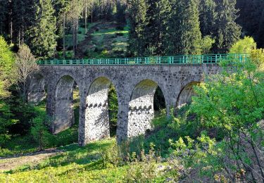
![Trail On foot Nové Hamry - [Č] Hamerská stezka - Photo](https://media.geolcdn.com/t/375/260/05e8c932-2579-4b34-823a-64f5275592a5.jpeg&format=jpg&maxdim=2)
![On foot On foot](https://static1.geolcdn.com/sitytour/trail-icons/100.png)
[Č] Hamerská stezka
On foot
Easy
Nové Hamry,
Northwest,
Karlovarský kraj,
Czech Republic
![](/images/other/stat-length.png)
5.7 km | 8.5 km-effort
1h 56min
![](https://static1.geolcdn.com/siteimages/upload/files/16400158638029165_repeat_loop_refresh_sync_direction_icon.png)
No
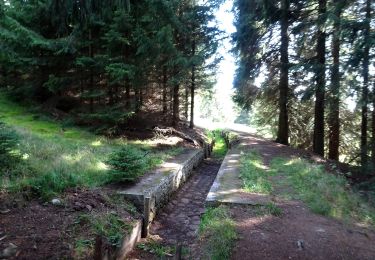
![Trail On foot Nové Hamry - [Z] Karlova naučná stezka - Photo](https://media.geolcdn.com/t/375/260/4f78281c-5919-4d9b-a138-fb6ccef06970.jpeg&format=jpg&maxdim=2)
![On foot On foot](https://static1.geolcdn.com/sitytour/trail-icons/100.png)
[Z] Karlova naučná stezka
On foot
Easy
Nové Hamry,
Northwest,
Karlovarský kraj,
Czech Republic
![](/images/other/stat-length.png)
9.3 km | 12.1 km-effort
2h 44min
![](https://static1.geolcdn.com/siteimages/upload/files/16400158638029165_repeat_loop_refresh_sync_direction_icon.png)
No
![Trail On foot Abertamy - Plešivecká NS - Photo](https://media.geolcdn.com/t/375/260/86500b83-4994-4814-823a-26a6ef9909eb.jpeg&format=jpg&maxdim=2)
![On foot On foot](https://static1.geolcdn.com/sitytour/trail-icons/100.png)
Plešivecká NS
On foot
Easy
Abertamy,
Northwest,
Karlovarský kraj,
Czech Republic
![](/images/other/stat-length.png)
8.6 km | 13.6 km-effort
3h 5min
![](https://static1.geolcdn.com/siteimages/upload/files/16400158638029165_repeat_loop_refresh_sync_direction_icon.png)
Yes
![Trail On foot Abertamy - NS Hřebečná - Photo](https://media.geolcdn.com/t/375/260/0731361c-b065-433d-ad42-217af59cca8a.jpeg&format=jpg&maxdim=2)
![On foot On foot](https://static1.geolcdn.com/sitytour/trail-icons/100.png)
NS Hřebečná
On foot
Easy
Abertamy,
Northwest,
Karlovarský kraj,
Czech Republic
![](/images/other/stat-length.png)
3.8 km | 4.5 km-effort
1h 1min
![](https://static1.geolcdn.com/siteimages/upload/files/16400158638029165_repeat_loop_refresh_sync_direction_icon.png)
No
![Trail On foot Pernink - [Z] Rennerova Stezka - Photo](https://media.geolcdn.com/t/375/260/9a32792c-7525-4a0a-b592-a7f6c6044227.jpeg&format=jpg&maxdim=2)
![On foot On foot](https://static1.geolcdn.com/sitytour/trail-icons/100.png)
[Z] Rennerova Stezka
On foot
Easy
Pernink,
Northwest,
Karlovarský kraj,
Czech Republic
![](/images/other/stat-length.png)
3.9 km | 5.9 km-effort
1h 20min
![](https://static1.geolcdn.com/siteimages/upload/files/16400158638029165_repeat_loop_refresh_sync_direction_icon.png)
Yes
![Trail On foot Potůčky - [Ž] Pernink - Nové Hamry - Photo](https://media.geolcdn.com/t/375/260/f5edafe6-81d2-4c68-9506-f8acbfbc5ef6.jpeg&format=jpg&maxdim=2)
![On foot On foot](https://static1.geolcdn.com/sitytour/trail-icons/100.png)
[Ž] Pernink - Nové Hamry
On foot
Medium
Potůčky,
Northwest,
Karlovarský kraj,
Czech Republic
![](/images/other/stat-length.png)
21 km | 30 km-effort
6h 53min
![](https://static1.geolcdn.com/siteimages/upload/files/16400158638029165_repeat_loop_refresh_sync_direction_icon.png)
No
![Trail On foot Abertamy - NS 17 Abertamských zastavení - Photo](https://media.geolcdn.com/t/375/260/20cf5f67-c98f-4239-8c8b-7169e95e1478.jpeg&format=jpg&maxdim=2)
![On foot On foot](https://static1.geolcdn.com/sitytour/trail-icons/100.png)
NS 17 Abertamských zastavení
On foot
Easy
Abertamy,
Northwest,
Karlovarský kraj,
Czech Republic
![](/images/other/stat-length.png)
5.8 km | 7.3 km-effort
1h 39min
![](https://static1.geolcdn.com/siteimages/upload/files/16400158638029165_repeat_loop_refresh_sync_direction_icon.png)
Yes