![](/images/other/stat-length.png)
![Trail On foot Dubí - [F] Dubský Cínovecký okruh - Photo](https://media.geolcdn.com/t/1900/400/c6545c9b-76f0-4a2c-85bc-e7700ca98aca.jpeg&format=pjpeg&maxdim=2)
[F] Dubský Cínovecký okruh
SityTrail - itinéraires balisés pédestres
Tous les sentiers balisés d’Europe GUIDE+
![Length](/images/other/stat-length.png)
Length
3.5 km
![Max alt](https://static1.geolcdn.com/siteimages/upload/files/1508320355ic_sort_altitude_max_24dp.png)
Max alt
873 m
![Uphill gradient](https://static1.geolcdn.com/siteimages/upload/files/1508320355ic_sort_den_pos_24dp.png)
Uphill gradient
51 m
![Km-Effort](/images/other/stat-length.png)
Km-Effort
4.3 km
![Min alt](https://static1.geolcdn.com/siteimages/upload/files/1508320355ic_sort_altitude_min_24dp.png)
Min alt
775 m
![Downhill gradient](https://static1.geolcdn.com/siteimages/upload/files/1508320355ic_sort_den_neg_24dp.png)
Downhill gradient
99 m
![Boucle](https://static1.geolcdn.com/siteimages/upload/files/16400158638029165_repeat_loop_refresh_sync_direction_icon.png)
Boucle
No
Signpost
Creation date :
2025-02-07 05:48:26.172
Updated on :
2025-02-07 05:48:26.172
![On foot](https://static1.geolcdn.com/sitytour/trail-icons/100.png)
58m
Difficulty : Easy
![Scan this QR Code to open this trail in the SityTrail application](https://capi.geolives.com/qq0zvz2zws4bq2lad0pu/sitytour/trails/4344714/qr.png?size=200)
FREE GPS app for hiking
About
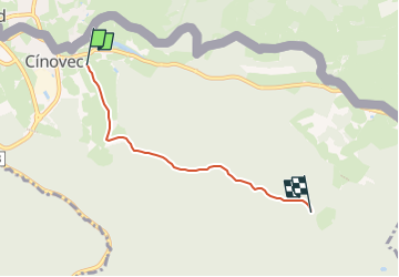
Trail On foot of 3.5 km to be discovered at Northwest, Ústecký kraj, Dubí. This trail is proposed by SityTrail - itinéraires balisés pédestres.
Description
Trail created by město Dubí.
Dubské vycházkové trasy
Positioning
Country:
Czech Republic
Region :
Northwest
Department/Province :
Ústecký kraj
Municipality :
Dubí
Location:
Unknown
Start:(Dec)
Start:(UTM)
413452 ; 5620683 (33U) N.
Comments
Trails nearby
![Trail On foot Dubí - [M] Okruh kolem Francouzského kamene - Photo](https://media.geolcdn.com/t/375/260/394e4c19-d604-4c61-b996-a104413a844a.jpeg&format=jpg&maxdim=2)
![On foot On foot](https://static1.geolcdn.com/sitytour/trail-icons/100.png)
[M] Okruh kolem Francouzského kamene
On foot
Easy
Dubí,
Northwest,
Ústecký kraj,
Czech Republic
![](/images/other/stat-length.png)
5.5 km | 8.4 km-effort
1h 54min
![](https://static1.geolcdn.com/siteimages/upload/files/16400158638029165_repeat_loop_refresh_sync_direction_icon.png)
Yes
![Trail On foot Dubí - [Ž] Dubský severní okruh - Photo](https://media.geolcdn.com/t/375/260/97c3e1ce-5fa7-4bc3-9b54-3ed8ed7e5f3a.jpeg&format=jpg&maxdim=2)
![On foot On foot](https://static1.geolcdn.com/sitytour/trail-icons/100.png)
[Ž] Dubský severní okruh
On foot
Easy
Dubí,
Northwest,
Ústecký kraj,
Czech Republic
![](/images/other/stat-length.png)
9.3 km | 14 km-effort
3h 10min
![](https://static1.geolcdn.com/siteimages/upload/files/16400158638029165_repeat_loop_refresh_sync_direction_icon.png)
Yes
![Trail On foot Altenberg - Hirschsprung - Geising - Photo](https://media.geolcdn.com/t/375/260/3e69ccf1-0b65-4c11-8f13-69e67c0e4d38.jpeg&format=jpg&maxdim=2)
![On foot On foot](https://static1.geolcdn.com/sitytour/trail-icons/100.png)
Hirschsprung - Geising
On foot
Easy
Altenberg,
Saxony,
Sächsische Schweiz-Osterzgebirge,
Germany
![](/images/other/stat-length.png)
4.6 km | 7.6 km-effort
1h 43min
![](https://static1.geolcdn.com/siteimages/upload/files/16400158638029165_repeat_loop_refresh_sync_direction_icon.png)
No
![Trail On foot Altenberg - Schmiedeberg - Altenberg - Photo](https://media.geolcdn.com/t/375/260/ext.jpg?maxdim=2&url=https%3A%2F%2Fstatic1.geolcdn.com%2Fsiteimages%2Fupload%2Ffiles%2F1545311037marcheuse_200dpi.jpg)
![On foot On foot](https://static1.geolcdn.com/sitytour/trail-icons/100.png)
Schmiedeberg - Altenberg
On foot
Easy
Altenberg,
Saxony,
Sächsische Schweiz-Osterzgebirge,
Germany
![](/images/other/stat-length.png)
6.3 km | 7.8 km-effort
1h 46min
![](https://static1.geolcdn.com/siteimages/upload/files/16400158638029165_repeat_loop_refresh_sync_direction_icon.png)
No
![Trail On foot Altenberg - Rotmarkierter Wanderweg - Photo](https://media.geolcdn.com/t/375/260/ext.jpg?maxdim=2&url=https%3A%2F%2Fstatic1.geolcdn.com%2Fsiteimages%2Fupload%2Ffiles%2F1545311037marcheuse_200dpi.jpg)
![On foot On foot](https://static1.geolcdn.com/sitytour/trail-icons/100.png)
Rotmarkierter Wanderweg
On foot
Easy
Altenberg,
Saxony,
Sächsische Schweiz-Osterzgebirge,
Germany
![](/images/other/stat-length.png)
3.6 km | 4.8 km-effort
1h 5min
![](https://static1.geolcdn.com/siteimages/upload/files/16400158638029165_repeat_loop_refresh_sync_direction_icon.png)
No
![Trail On foot Altenberg - Lehrpfad Nr. 6 - Photo](https://media.geolcdn.com/t/375/260/ext.jpg?maxdim=2&url=https%3A%2F%2Fstatic1.geolcdn.com%2Fsiteimages%2Fupload%2Ffiles%2F1545311037marcheuse_200dpi.jpg)
![On foot On foot](https://static1.geolcdn.com/sitytour/trail-icons/100.png)
Lehrpfad Nr. 6
On foot
Easy
Altenberg,
Saxony,
Sächsische Schweiz-Osterzgebirge,
Germany
![](/images/other/stat-length.png)
3.3 km | 4 km-effort
54min
![](https://static1.geolcdn.com/siteimages/upload/files/16400158638029165_repeat_loop_refresh_sync_direction_icon.png)
No
![Trail On foot Altenberg - Rehefeld-Zinnwald - Photo](https://media.geolcdn.com/t/375/260/ext.jpg?maxdim=2&url=https%3A%2F%2Fstatic1.geolcdn.com%2Fsiteimages%2Fupload%2Ffiles%2F1545311037marcheuse_200dpi.jpg)
![On foot On foot](https://static1.geolcdn.com/sitytour/trail-icons/100.png)
Rehefeld-Zinnwald
On foot
Easy
Altenberg,
Saxony,
Sächsische Schweiz-Osterzgebirge,
Germany
![](/images/other/stat-length.png)
4.1 km | 5.9 km-effort
1h 20min
![](https://static1.geolcdn.com/siteimages/upload/files/16400158638029165_repeat_loop_refresh_sync_direction_icon.png)
No
![Trail On foot Altenberg - Grüner Balken - Photo](https://media.geolcdn.com/t/375/260/ext.jpg?maxdim=2&url=https%3A%2F%2Fstatic1.geolcdn.com%2Fsiteimages%2Fupload%2Ffiles%2F1545311037marcheuse_200dpi.jpg)
![On foot On foot](https://static1.geolcdn.com/sitytour/trail-icons/100.png)
Grüner Balken
On foot
Easy
Altenberg,
Saxony,
Sächsische Schweiz-Osterzgebirge,
Germany
![](/images/other/stat-length.png)
4.6 km | 6.3 km-effort
1h 25min
![](https://static1.geolcdn.com/siteimages/upload/files/16400158638029165_repeat_loop_refresh_sync_direction_icon.png)
No
![Trail On foot Mikulov - Sklářská NS - Photo](https://media.geolcdn.com/t/375/260/b7c25c96-f53a-4e8a-b4e4-c4dbddd64bdc.jpeg&format=jpg&maxdim=2)
![On foot On foot](https://static1.geolcdn.com/sitytour/trail-icons/100.png)
Sklářská NS
On foot
Medium
Mikulov,
Northwest,
Ústecký kraj,
Czech Republic
![](/images/other/stat-length.png)
17.4 km | 21 km-effort
4h 51min
![](https://static1.geolcdn.com/siteimages/upload/files/16400158638029165_repeat_loop_refresh_sync_direction_icon.png)
Yes