


3.5 km | 4.8 km-effort
![Trail On foot Semtěš - [Ž] Konopáč - Semtěš - Photo](https://media.geolcdn.com/t/1900/400/4b4cb51a-3f87-4840-8d60-7e3ab3cd869f.jpeg&format=pjpeg&maxdim=2)

Tous les sentiers balisés d’Europe GUIDE+


FREE GPS app for hiking
 SityTrail
IGN / Geographical institutes
SityTrail World
The world is yours!
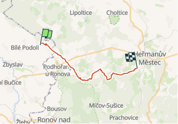
Trail On foot of 13.9 km to be discovered at Central Bohemia, Unknown, Semtěš. This trail is proposed by SityTrail - itinéraires balisés pédestres.
Trail created by cz:KČT.
![Trail On foot Semtěš - [Ž] Konopáč - Semtěš - Photo 1](https://media.geolcdn.com/t/2048/auto/1898eb85-99f0-41ff-9cfa-aed059bc5047.jpeg&format=jpg&maxdim=0 "Trail On foot Semtěš - [Ž] Konopáč - Semtěš - Photo 1")
![Trail On foot Semtěš - [Ž] Konopáč - Semtěš - Photo 2](https://media.geolcdn.com/t/2048/auto/2b1552fc-6041-4b85-83a4-d235db6ce3f4.jpeg&format=jpg&maxdim=0 "Trail On foot Semtěš - [Ž] Konopáč - Semtěš - Photo 2")
![Trail On foot Semtěš - [Ž] Konopáč - Semtěš - Photo 3](https://media.geolcdn.com/t/2048/auto/0e38d7d5-19d1-4878-af9e-b26210aeae65.jpeg&format=jpg&maxdim=0 "Trail On foot Semtěš - [Ž] Konopáč - Semtěš - Photo 3")
![Trail On foot Semtěš - [Ž] Konopáč - Semtěš - Photo 4](https://media.geolcdn.com/t/2048/auto/f61d260b-607a-4519-a0af-994f6c85f45e.jpeg&format=jpg&maxdim=0 "Trail On foot Semtěš - [Ž] Konopáč - Semtěš - Photo 4")
![Trail On foot Semtěš - [Ž] Konopáč - Semtěš - Photo 5](https://media.geolcdn.com/t/2048/auto/51044ffb-0f31-45c2-87a9-a08c262e9194.jpeg&format=jpg&maxdim=0 "Trail On foot Semtěš - [Ž] Konopáč - Semtěš - Photo 5")
![Trail On foot Semtěš - [Ž] Konopáč - Semtěš - Photo 6](https://media.geolcdn.com/t/2048/auto/b951d761-6dfa-4300-bf64-f9882860a218.jpeg&format=jpg&maxdim=0 "Trail On foot Semtěš - [Ž] Konopáč - Semtěš - Photo 6")
![Trail On foot Semtěš - [Ž] Konopáč - Semtěš - Photo 7](https://media.geolcdn.com/t/2048/auto/d34907ac-fa0f-40ad-b8e0-81a2b6a5706a.jpeg&format=jpg&maxdim=0 "Trail On foot Semtěš - [Ž] Konopáč - Semtěš - Photo 7")
![Trail On foot Semtěš - [Ž] Konopáč - Semtěš - Photo 8](https://media.geolcdn.com/t/2048/auto/f5ceb4c2-3a22-4323-b8e3-6b980d1969fc.jpeg&format=jpg&maxdim=0 "Trail On foot Semtěš - [Ž] Konopáč - Semtěš - Photo 8")
![Trail On foot Semtěš - [Ž] Konopáč - Semtěš - Photo 9](https://media.geolcdn.com/t/2048/auto/4b4cb51a-3f87-4840-8d60-7e3ab3cd869f.jpeg&format=jpg&maxdim=0 "Trail On foot Semtěš - [Ž] Konopáč - Semtěš - Photo 9")
![Trail On foot Semtěš - [Ž] Konopáč - Semtěš - Photo 10](https://media.geolcdn.com/t/2048/auto/76687ce3-5aca-46ce-9758-41ed48e6b7f0.jpeg&format=jpg&maxdim=0 "Trail On foot Semtěš - [Ž] Konopáč - Semtěš - Photo 10")
![Trail On foot Semtěš - [M] Sovoluská Lhota - Semtěš - Photo](https://media.geolcdn.com/t/375/260/6dcc2a2d-a7c6-4ace-9e33-9a21e2524107.jpeg&format=jpg&maxdim=2)
On foot
![Trail On foot Zdechovice - [Ž] Morašice - Svojšice - Photo](https://media.geolcdn.com/t/375/260/f143d729-598a-40d2-b273-3cfaab803058.jpeg&format=jpg&maxdim=2)
On foot