


7.2 km | 9.9 km-effort
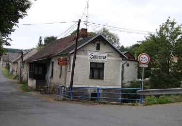
![Trail On foot Obecnice - [Z] Pila - Bohutín - Photo](https://media.geolcdn.com/t/1900/400/ed2c13c9-f98d-44a7-859e-fcc2745957f4.jpeg&format=pjpeg&maxdim=2)

Tous les sentiers balisés d’Europe GUIDE+


FREE GPS app for hiking
 SityTrail
IGN / Geographical institutes
SityTrail World
The world is yours!
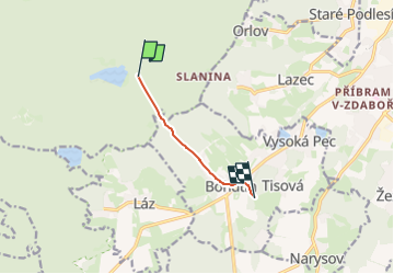
Trail On foot of 4.1 km to be discovered at Central Bohemia, Unknown, Obecnice. This trail is proposed by SityTrail - itinéraires balisés pédestres.
Trail created by cz:KČT.
![Trail On foot Obecnice - [Z] Pila - Bohutín - Photo 1](https://media.geolcdn.com/t/2048/auto/7381c4f3-f558-4098-9261-ea36b6808287.jpeg&format=jpg&maxdim=0 "Trail On foot Obecnice - [Z] Pila - Bohutín - Photo 1")
![Trail On foot Obecnice - [Z] Pila - Bohutín - Photo 2](https://media.geolcdn.com/t/2048/auto/b1053a92-ee44-4945-acfd-4a6c506a9af6.jpeg&format=jpg&maxdim=0 "Trail On foot Obecnice - [Z] Pila - Bohutín - Photo 2")
![Trail On foot Obecnice - [Z] Pila - Bohutín - Photo 3](https://media.geolcdn.com/t/2048/auto/e8f01f70-726d-4d59-977e-5892c0397500.jpeg&format=jpg&maxdim=0 "Trail On foot Obecnice - [Z] Pila - Bohutín - Photo 3")
![Trail On foot Obecnice - [Z] Pila - Bohutín - Photo 4](https://media.geolcdn.com/t/2048/auto/85bf506f-9153-455d-84ad-daf1c8b360d1.jpeg&format=jpg&maxdim=0 "Trail On foot Obecnice - [Z] Pila - Bohutín - Photo 4")
![Trail On foot Obecnice - [Z] Pila - Bohutín - Photo 5](https://media.geolcdn.com/t/2048/auto/ed2c13c9-f98d-44a7-859e-fcc2745957f4.jpeg&format=jpg&maxdim=0 "Trail On foot Obecnice - [Z] Pila - Bohutín - Photo 5")
![Trail On foot Obecnice - [Z] Pila - Bohutín - Photo 6](https://media.geolcdn.com/t/2048/auto/7e421908-d2d4-4839-ad93-cdb70c156aa5.jpeg&format=jpg&maxdim=0 "Trail On foot Obecnice - [Z] Pila - Bohutín - Photo 6")
On foot
![Trail On foot Obecnice - [M] Orlov - Třemošná , místní okruh - Photo](https://media.geolcdn.com/t/375/260/eba4fd36-4577-4ad0-82a2-9f28ca4bc9f7.jpeg&format=jpg&maxdim=2)
On foot
![Trail On foot Obecnice - [Z] Křesín - Dlouhý kámen - Photo](https://media.geolcdn.com/t/375/260/a0381e44-f2e0-4d28-a412-1a9454739cbf.jpeg&format=jpg&maxdim=2)
On foot